USGS Geoscience Data Catalog
Additional USGS Geoscience data can be found by geographic location or by publication series.
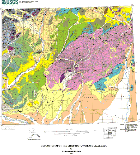
Brosgé, W.P., and Reiser, H.N., 2000, Geologic map of the Christian quadrangle, Alaska: U.S. Geological Survey Open-File Report 00-192.Online Links:
This is a Vector data set.
Planar coordinates are encoded using coordinate pair
Abscissae (x-coordinates) are specified to the nearest 250
Ordinates (y-coordinates) are specified to the nearest 250
Planar coordinates are specified in meters
| Value | Definition |
|---|---|
| 1 | Stratigraphic or intrusive contact, location certain |
| 2 | Stratigraphic or intrusive contact, location approximate |
| 3 | Stratigraphic or intrusive contact, location inferred |
| 7 | Shoreline or riverbank |
| 9 | Boundary of local basal conglomerate |
| 10 | Thrust fault, location certain; teeth on right from origin |
| 11 | Thrust fault, location approximate; teeth on right from origin |
| 12 | Thrust fault, location inferred; teeth on right from origin |
| 13 | Moraine |
| 30 | Fault, sense of displacement uncertain, location certain |
| 31 | Fault, sense of displacement uncertain; location approximate |
| 32 | Fault, sense of displacement uncertain, location inferred |
| 51 | Concealed contact |
| 52 | Concealed fault |
| 53 | Concealed thrust fault |
| 99 | Bounding line of coverage |
| Value | Definition |
|---|---|
| 102 | water |
| 110 | Qu - Undifferentiated deposits (Quaternary) |
| 111 | Qal - Alluvium (Holocene) |
| 120 | Qg - Glacial drift undifferentiated (Pleistocene) |
| 121 | Qg1 - Dift of Itkillik I glaciation (Middle to Upper Pleistocene) |
| 122 | Qg2 - Dift of Itkillik II glaciation (Upper Pleistocene) |
| 123 | Qgs - Drift of Sagavanirktok glaciation (Middle(?) Pleistocene) |
| 125 | Qt - Terrace deposits (Pleistocene) |
| 130 | Jol - Ophiolitic sequence; layered leucogabbro (Middle Jurassic) |
| 131 | Jou - Ophiolitic sequence; ultramafic rocks (Middle Jurassic) |
| 135 | Kgr - Granite (Cretaceous) |
| 140 | Trgw - Graywacke (Middle or Lower Triassic) |
| 145 | TrMc - Chert and argillite (Triassic(?) through Mississippian) |
| 150 | JMv - Mafic volcanic rocks (Jurassic through Mississippian) |
| 151 | JMvr - Rhyolite and dacite (Jurassic through Mississippian) |
| 152 | JMg - Greenstone (Jurassic through Mississippian) |
| 154 | MzPzs - Shale (Mesozoic or Paleozoic) |
| 155 | MzPzg - Greenstone (Triassic or Upper Paleozoic) |
| 160 | Dsl - Sandy limestone (Upper Devonian) |
| 161 | Dsq - Quartzite and slate (Devonian) |
| 162 | Ds - Phyllite (Devonian) |
| 165 | Dpm - Phyllite and metamorphosed sandstone (Devonian) |
| 166 | Dmw - Metamorphosed wacke (Devonian) |
| 167 | Dw - Wacke (Devonian) |
| 170 | Dhf - Hunt Fork Shale, shale member (Upper Devonian) |
| 171 | Dvt - Volcanic rocks and tuff (Upper Devonian) |
| 180 | Dk - Kanayut Conglomerate (Upper Devonian) |
| 190 | Dkq - Kanayut Conglomerate, quartzite member (Upper Devonian) |
| 195 | Dn - Noatak Sandstone (Upper Devonian) |
| 197 | Dg - Greenstone (Devonian and younger?) |
| 200 | Dbsg - Beaucoup Formation, siltstone, greenstone and wacke member (Upper and Middle(?) Devonian) |
| 210 | Dbl - Beaucoup Formation cherty limestone (Upper and Middle(?) Devonian) |
| 211 | Dbls - Beaucoup Formation, limestone and siltstone member (Upper Devonian) |
| 215 | DOs - Skajit Limestone (Devonian through Ordovician) |
| 220 | Pzs - Quartz-muscovite schist (Lower Paleozoic) |
| 221 | Pzbs - Biotite schist (Lower Paleozoic) |
| 222 | TrMcs - Chert adn slate (Triassic(?) through Mississippian) |
| 1170 | Dhf - Hunt Fork Shale, local basal conglomerate (Upper Devonian) |
| Range of values | |
|---|---|
| Minimum: | 0 |
| Maximum: | 360 |
| Units: | degrees |
| Range of values | |
|---|---|
| Minimum: | 0 |
| Maximum: | 90 |
| Units: | degrees |
| Value | Definition |
|---|---|
| 20 | strike and dip of bedding |
| 21 | strike and dip of vertical beds |
| 23 | horizontal bed |
| 49 | strike and direction of dip of beds from distant views or photo-interpretations |
This digital coverage was created by Keith Labay and David Pray, Raytheon STX contractors.
650-329-5741 (voice)
brosge@usgs.gov
Digital representation of geologic mapping facilitates the presentation and analysis of earth-science data. Digital maps may be displayed at any scale or projection, however the geologic data in this coverage is not intended for use at a scale larger than 1:250,000.
Person who carried out this activity:
907-561-1181 (voice)
nshew@usgs.gov
The linework was captured by hand digitizing from a hand-drawn 1:250,000 scale paper map. Vector and polygon attributes were obtained from a compilation of field maps and other compilations. The digital data has been visually checked by and the geologic map has undergone technical review.
Users of this digital geologic map should respect the intentions of the original mappers and the limitations of the map. This geologic map compilation is intended to be used at a scale of 1:250,000; it is not intended to be used at a more detailed scale.
These coverages were used to create the map portion of the Christian geologic map. Text files, tables, graphics, and topography shown on the map sheet or pamphlet are not included.
This geology data set is a network coverage containing
arcs and polygons. Each polygon has a coded attribute
designating the mapped geologic unit. Faults,
stratigraphic contacts, and other linear features are
represented as arcs. When a fault is also a
stratigraphic contact, only a single arc is present.
Dangling arcs may be present (faults, moraines, etc.)
Coverage csfold is an arc coverage containing fold
axes information. Coverage csstruct is a point coverage,
with annotation, containing strike and dip information.
Coverage csfossil contains the fossil locations.
Are there legal restrictions on access or use of the data?
- Access_Constraints: None
- Use_Constraints: None
303-202-4200 or 1-888-ASK-USGS (voice)
USGS Open-File Report 00-192
Although this data has been used by the USGS, no warranty, expressed or implied, is made by the USGS as to the accuracy of the data and related materials. The act of distribution shall not constitute any such warranty, and no responsibility is assumed by the USGS in the use of these data, software, or related materials.
907-561-1181 (voice)
nshew@usgs.gov

![]() U.S. Department of the Interior |
U.S. Geological Survey
U.S. Department of the Interior |
U.S. Geological Survey
URL: http://geo-nsdi.er.usgs.gov/metadata/open-file/00-192/metadata.faq.html
Page Contact Information: Peter Schweitzer
Page Last Modified: Monday, 10-Nov-2008 12:18:40 EST
