USGS Geoscience Data Catalog
Additional USGS Geoscience data can be found by geographic location or by publication series.
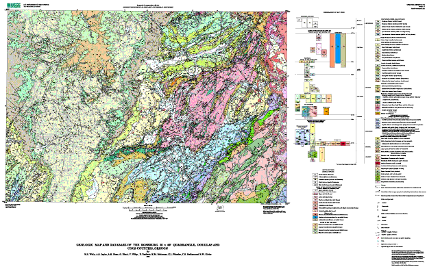
Wells, R.E., Jayko, A.S., Niem, A.R., Black, G., Wiley, T., Baldwin, E., Molenaar, K.M., Wheeler, K.L., DuRoss, C.B., and Givler, R.W., 2000, Geologic map and database of the Roseburg 30 x 60 minute quadrangle, Douglas and Coos Counties, Oregon: U.S. Geological Survey Open-File Report 00-376, U.S. Geological Survey, Menlo Park, CA.Online Links:
This is a Vector data set. It contains the following vector data types (SDTS terminology):
Planar coordinates are encoded using coordinate pair
Abscissae (x-coordinates) are specified to the nearest 0.000128
Ordinates (y-coordinates) are specified to the nearest 0.000128
Planar coordinates are specified in meters
The horizontal datum used is North American Datum of 1927.
The ellipsoid used is Clarke 1866.
The semi-major axis of the ellipsoid used is 6378206.4.
The flattening of the ellipsoid used is 1/294.98.
| Value | Definition |
|---|---|
| Qf | Fluvial deposits (Holocene) |
| Qcl | Colluvium (Holocene and Pleistocene) |
| Qls | Landslide deposits (Holocene and Pleistocene) |
| Qft | Fluvial terrace deposits (Pleistocene) |
| Qoft | Older Fluvial terrace deposits (Pleistocene) |
| Td | Upper dacite (late Eocene) |
| Tbcu | Tuff of Bond Creek (late Eocene) upper unit |
| Tbcl | Tuff of Bond Creek (late Eocene) lower unit |
| Tbf | Basalt of Brown Mountain (late Eocene) |
| Taf | Andesite flows (late Eocene) |
| Tsf | Rhyolite and dacite flows (late Eocene) |
| Tvs | Volcanolithic sandstone, conglomerate, and laharic breccia (late Eocene) |
| Tc | Colestin Formation (late Eocene?) |
| Tis | Rhyolite and dacite intrusions (late and middle Eocene) |
| Tib | Diabase and basalt intrusions (late and middle Eocene) |
| Tia | Andesite dikes and sills (late and middle Eocene) |
| Tes | Spencer Formation (late and middle Eocene) |
| Teb | Bateman Formation (late and middle Eocene) |
| Tebm | Bateman Formation mudstone (late and middle Eocene) |
| Tee | Elkton Formation mudstone (middle Eocene) |
| Ttbs | Tyee Formation, Baughman Member (middle Eocene) |
| Ttbm | Tyee Formation, Baughman Member mudstone (middle and early Eocene) |
| Tth | Tyee Formation, Hubbard Creek Member (middle and early Eocene) |
| Tths | Tyee Formation, Hubbard Creek Member sandstone (middle Eocene) |
| Ttts | Tyee Formation, Tyee Mountain Member (middle and early Eocene) |
| Tttm | Tyee Formation, Tyee Mountain Member mudstone (middle and early Eocene) |
| Tcv | Camas Valley Formation (early Eocene) |
| Tw | White Tail Ridge Formation, undivided (early Eocene) |
| Twrc | White Tail Ridge Formation, Rasler Creek tongue (early Eocene) |
| Twc | White Tail Ridge Formation, Coquille River Member (early Eocene) |
| Twr | White Tail Ridge Formation, Remote Member (early Eocene) |
| Twrm | White Tail Ridge Formation, Remote Member Mudstone (early Eocene) |
| Twbc | White Tail Ridge Formation, Berry Creek Member (early Eocene) |
| Twst | White Tail Ridge Formation, Unnamed siltstone member (early Eocene) |
| Tm | Tenmile Formation, undivided (early Eocene) |
| Tmsl | Tenmile Formation, Slope mudstone (early Eocene) |
| Tmsm | Tenmile Formation, Turbidite sandstone and mudstone (early Eocene) |
| Tmss | Tenmile Formation, Turbidite sandstone (early Eocene) |
| Tmm | Tenmile Formation, Basin plain mudstone (early Eocene) |
| Tmms | Tenmile Formation, Mudstone and turbidite sandstone (early Eocene) |
| Tmcs | Tenmile Formation, Submarine fan channel sandstone (early Eocene) |
| Tbsc | Bushnell Rock Formation, Slater Creek Member (early Eocene) |
| Tbr | Bushnell Rock Formation, conglomerate (early Eocene) |
| Tbrm | Bushnell Rock Formation, Debris flow deposits (early Eocene) |
| Trbs | Siletz River Volcanics, Roseburg Member, Basaltic sandstone (early Eocene) |
| Trs | Siletz River Volcanics, Roseburg Member, Turbidite sandstone and mudstone (early Eocene) |
| Trc | Siletz River Volcanics, Roseburg Member, Conglomerate (early Eocene) |
| Tsrt | Siletz River Volcanics, Basalt tuff (early Eocene) |
| Tsru | Siletz River Volcanics, Subaerial basalt flows (early Eocene and late Paleocene) |
| Tsr | Siletz River Volcanics, submarine basalt flows (early Eocene) |
| Tidb | Diabase (early Eocene) |
| KJda | Dothan Formation, turbidite sandstone broken formation (early Cretaceous and late Jurassic) |
| KJdm | Dothan Formation, mudstone matrix melange (early Cretaceous and late Jurassic) |
| KJdd | Dothan Formation, phyllitic siltstone and metagreywacke (early Cretaceous and late Jurassic) |
| KJd2 | Dothan Formation, semischist and phyllite (early Cretaceous and late Jurassic) |
| Kdc | Myrtle Group, Days Creek Formation (middle and early Cretaceous) |
| KJr | Riddle Formation (Early Cretaceous to Late Jurassic?) |
| KJrc | Riddle Formation conglomerate (Early Cretaceous to Late Jurassic?) |
| KJms | Metasedimentary rock (early Cretaceous and late Jurassic) |
| KJhf | Mafic silicified hornfels (Cretaceous, Jurassic, or both) |
| KJag | Augen gneiss (Cretaceous, Jurassic, or both) |
| KJi | Intrusive rocks (Cretaceous, Jurassic, or both) |
| KJgd | Granodiorite (Cretaceous, Jurassic, or both) |
| KJhd | Hornblende diorite (Cretaceous, Jurassic, or both) |
| KJdi | Diorite (Cretaceous, Jurassic, or both) |
| KJdt | Tectonized diorite (Cretaceous, Jurassic, or both) |
| m | Metamorphic complex (Jurassic or older) |
| Jrv | Rogue volcanics? (late Jurassic?) |
| Jri | Mafic intrusive unit (late Jurassic?) |
| Jrvs | Schistose Rogue volcanics (late Jurassic) |
| Jris | Schistose mafic intrusive unit (late Jurassic) |
| Jrs | Serpentinized ultramafic rock (Jurassic?) |
| amp | |
| bs | |
| cht | |
| di | |
| dio | |
| gs | |
| gs-di | |
| kn | |
| ls | |
| mv | |
| sp | |
| sp+gs | |
| water |
| Value | Definition |
|---|---|
| atten. fault, certain | |
| atten. fault, concealed | |
| atten. fault, inferred | |
| atten. fault, inferred, queried | |
| contact, certain | |
| contact, concealed | |
| contact, concealed, queried | |
| contact, inferred | |
| contact, inferred, queried | |
| dike | |
| fault inferred | |
| fault, approx. located | |
| fault, certain | |
| fault, certainm | |
| fault, concealed | |
| fault, concealed, queried | |
| detachment fault, certain | |
| detachment fault, inferred | |
| detachment fault, inferred, queried | |
| fault, inferred | |
| fault, inferred, queried | |
| map boundary, certain | |
| normal fault, certain | |
| normal fault, certainm | |
| normal fault, concealed | |
| normal fault, concealedm | |
| normal fault, inferred | |
| normal fault, inferred, queried | |
| normal fault, inferred, queriedm | |
| normal fault, inferredm | |
| s.s. fault, l.l., certain | |
| s.s. fault, r.l., certain | |
| s.s. fault, r.l., concealed | |
| scratch boundary, certain | |
| shear zone, certain | |
| thrust fault, certain | |
| thrust fault, concealed | |
| thrust fault, concealed, queried | |
| thrust fault, inferred | |
| thrust fault, inferred, queried | |
| thrust fault, inferred, queried_ | |
| water boundary, certain |
| Value | Definition |
|---|---|
| _l_lineation_i_ | |
| air photo attitude | |
| anticline | |
| bedding | |
| bedding w/tops | |
| crumpled bedding | |
| crumpled foliation | |
| fault dip | |
| fault plane | |
| fault, ss, ll | |
| fault, ss, rl | |
| flat bedding | |
| flow_2dir | |
| flow_dir | |
| fold axis | |
| fold_axis | |
| foliation | |
| foliation and bedding | |
| igneous foliation | |
| inclined cleavage | |
| joint | |
| joint unmineralized | |
| _l_slick_i_r_ | |
| lava_tube | |
| lineation | |
| ot bedding | |
| ot bedding w/tops | |
| slick | |
| small syncline | |
| vert bedding | |
| vert bedding w/tops | |
| vert foliation | |
| vert foliation and bedding | |
| vert joint | |
| vertical bedding | |
| vertical fault plane | |
| zfold |
| Value | Definition |
|---|---|
| f.a., anticline, certain | |
| f.a., anticline, certainm | |
| f.a., anticline, concealed | |
| f.a., anticline, concealed, queried | |
| f.a., anticline, concealedm | |
| f.a., anticline, inferred | |
| f.a., anticline, inferred, queried | |
| f.a., anticline, inferredm | |
| f.a., anticline, plunge | |
| f.a., o.t. anticline, certain | |
| f.a., o.t. anticline, certainm | |
| f.a., o.t. syncline, certain | |
| f.a., o.t. syncline, certainm | |
| f.a., o.t. syncline, inferred | |
| f.a., syncline, certain | |
| f.a., syncline, certainm | |
| f.a., syncline, concealed | |
| f.a., syncline, concealedm | |
| f.a., syncline, inferred | |
| f.a., syncline, inferred, queried | |
| f.a., syncline, inferredm | |
| f.a., syncline, plunge |
| Value | Definition |
|---|---|
| cross-section line |
650-329-4933 (voice)
rwells@usgs.gov
This database and accompanying plot files depict the distribution of geologic materials and structures at a regional (1:100,000) scale. The report is intended to provide geologic information for the regional study of materials properties, earthquake shaking, landslide potential, mineral hazards, seismic velocity, and earthquake faults. In addition, the report contains new information and interpretations about the regional geologic history and framework. However, the regional scale of this report does not provide sufficient detail for site development purposes. In addition, this map does not take the place of fault-rupture hazard zones designated by the Oregon State Geologist. Similarly, the database cannot be used to identify or delineate landslides in the region.
Wiley, T. J., 1995, Reconnaissance geologic map of the Dora and Sitkum quadrangles, Coos County, Oregon: Oregon Department of Geology and Mineral Industries Geological Map Series GMS-98.
Wiley, T. J., Priest, G.R., and Black, G. L., 1994, Geologic map of the Mt. Gurney quadrangle, Douglas and Coos counties, Oregon: Oregon Deptartment of Geology and Mineral Industries Geologic Map Series GMS-85.
Black, G. L., 1990, Geologic map of the Reston quadrangle, Douglas County, Oregon: Oregon Deptartment of Geology and Mineral Industries Geologic Map Series GMS-68.
Jayko, A. S. and Wells, and E., R., 1999, Reconnaissance geologic map of the Dixonville 7.5' quadrangle, Oregon: U.S. Geological Survey Open-File Report.
Jayko, A. S., 1996, Reconnaissance geologic map of the Lane Mountain 7.5 minute quadrangle, Oregon: U.S. Geological Survey Open-File Report 95-20.
Jayko, A. S., 1996, Reconnaissance geologic map of the White Rock 7.5 minute quadrangle, Oregon: U.S. Geological Survey Open-File Report.
Black, G. L., 1994, Geologic map of the Kenyon Mountain quadrangle, Douglas and Coos counties, Oregon: Oregon Deptartment of Geology and Mineral Industries Geologic Map Series GMS-83.
Black, G. L., 1994, Geologic map of the Remote quadrangle, Coos County, Oregon: Oregon Deptartment of Geology and Mineral Industries Geologic Map Series GMS-84.
Black, G. L. and Priest, and R., G., 1993, Geologic map of the Camas Valley quadrangle, Douglas and Coos counties, Oregon: Oregon Deptartment of Geology and Mineral Industries Geologic Map Series GMS-76.
Jayko, A. S. and Gallagher, and M., 1997, Reconnaissance geologic map of the Myrtle Creek 7.5' quadrangle, Oregon: U.S. Geological Survey Open-File Report.
Jayko, A. S., 1997, Reconnaissance geologic map of the Dodson Butte 7.5' quadrangle, Oregon: U.S. Geological Survey Open-File Report.
 Golden Falls:     Molenaar, Black, Wells (1996)
 Ivers Peak:       Molenaar, Black, Wells, Wheeler (1996)
 Kelly Butte:      Baldwin, unpublished, Wells
 Tyee:             Baldwin, unpublished, Wells
 Tyee Mountain:    Wells, 1994 mapping
 Sutherlin:        Wells, 1994 mapping
 Nonpareil:        Wells, 1994 mapping
 Hinkle Creek:     Wells, 1995 mapping
 Coos Mountain:    Molenaar, Black, Wells (1996)
 Tioga:            Wells, Molenaar and Black (1996)
 Cedar Creek:      Wells, 1995 mapping
 Callahan:         Wells and Smith, 1994 mapping
 Garden Valley:    Felger, Abolins, and Wells (1992)
 Winchester:       Wells, 1992 mapping
 Oak Creek Valley: Wells, 1993 mapping
 Glide:            Wells and Niem, 1995 mapping
 Dora:             Wiley (1995)
 Sitkum:           Wiley (1995)
 Mt. Gurney:       Wiley, Priest and Black (1994)
 Reston:           Black (1990)
 Roseburg West:    Wells, 1990-1991 mapping
 Roseburg East:    Wells, 1990-1991 mapping
 Dixonville:       Jayko and Wells (1999)
 Lane Mountain:    Jayko(1996)
 Remote:           Black (1995)
 Kenyon Mountain:  Black (1994)
 Camas Valley:     Black and Priest (1993)
 Tenmile:          Black (1990)
 Winston:          Jayko (unpublished mapping)
 Myrtle Creek:     Jayko and Gallagher (1997)
 Dodson Butte:     Jayko (1997)
 White Rock:       Jayko (1996)
Data sources produced in this process:
Are there legal restrictions on access or use of the data?
- Access_Constraints: none
- Use_Constraints:
- Uses of this digital geologic map should not violate the spatial resolution of the data. Although the digital form of the data removes the constraint imposed by the scale of a paper map, the detail and accuracy inherent in map scale are also present in the digital data. The fact that this database was edited for a scale of 1:100,000 means that higher resolution information is not present in the dataset. Plotting at scales larger than 1:100,000 will not yield greater real detail, although it may reveal fine- scale irregularities below the intended resolution of the database. Similarly, where this database is used in combination with other data of higher resolution, the resolution of the combined output will be limited by the lower resolution of these data.
USGS Open-File Report 00-376
This report is preliminary and has not been reviewed for conformity with U.S. Geological Survey editorial standards or with the North American Stratigraphic Code. Any use of trade, firm, or product names is for descriptive purposes only and does not imply endorsement by the U.S. Government.
| Data format: | Exported coverages rb_geo, rb_well, rb_stx, and rb_xsec and supporting files in format Arc/Info export (version 7.2.1) Size: 31 megabytes |
|---|---|
| Network links: |
<http://geopubs.wr.usgs.gov/open-file/of00-376/rbofr.tar.gz> |
650-329-4935 (voice)
650-329-4936 (FAX)
kwheeler@usgs.gov

![]() U.S. Department of the Interior |
U.S. Geological Survey
U.S. Department of the Interior |
U.S. Geological Survey
URL: http://geo-nsdi.er.usgs.gov/metadata/open-file/00-376/metadata.faq.html
Page Contact Information: Peter Schweitzer
Page Last Modified: Monday, 10-Nov-2008 12:18:44 EST
