When you connect to the NBII Metadata Clearinghouse you will be able to search through metadata-based descriptions of biological data sets and information products from many different sources to identify those that meet your particular search criteria.
The NBII Metadata Clearinghouse: http://metadata.nbii.gov/
The NBII Home Page: http://www.nbii.gov/
Powered by Mercury
Time data from 1981 to 1986 listed in the database should also be used with caution. The sample was almost always taken near the 1000 EST time; however, the many different technicians collecting the water sample RECORDED the time in different ways (i.e. most people recorded the time in DST which means around 1100; however, some may have recorded the time as EST). There were also times when the boat or truck broke down, when the weather was very bad, or when other technicians may have taken the sample during holidays; this means that the water sample could have been either early or later than the ideal 1000 EST when the sample should have been taken. There is no way to know which 1000 times recorded during the summers were early samples or whether they were recorded as EST. Beginning in 1987, a watch, which was always kept on EST, was placed along with the water sampling collecting gear; the time data from 1987 until 1993 were all recorded as EST. A new time variable called EST time was created for this database which subtracts 1 hour for recorded times greater than 1030 for April through October from 1981 to 1986. It is only an estimated correction factor, so use these data with caution!
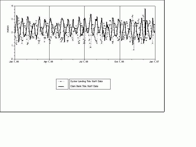
Tide staffs were nailed on pier pilings at the three sites, OL, CB, and TC. The tide staff at OL was placed upside down in order to measure water depth (or tide height) not tidal magnitude and was not calibrated to the other two sites. Therefore the tide elevation data at Oyster Landing (OL) will be reversed from the other two sites. USE THE TIDE ELEVATION DATA WITH CAUTION! See figure http://links.baruch.sc.edu/data/LTERDWS/metadata/CBvsOLtidestaffData.gif
Note that Daily Water Sample (DWS) name stood for the entire sampling program itself (one water sample everyday at 10 am EST) as well as the nutrient chemistry database (not sediments or chlorophyll - but the same water for the DWS nutrient analysis was used for sediment and phytoplankton analysis). In 1978 the original sampling program started out by taking just one sample at Town Creek every day and analyzing the water sample for TOC. The rest of the water analysis and sampling sites grew from there in 1981.
The final variables in the database listed in order are: Date, site, time, total whole nitrogen, total dissolved nitrogen, total whole phosphorus, total dissolved phosphorus, ortho phosphate, ammonia, nitrate-nitrite, dissolved organic carbon, total suspended sediment, inorganic suspended sediment, organic suspended sediment, chlorophyll a, salinity, tide elevation, water temperature, secchi depth, total organic carbon, particulate organic carbon, phaeophytin, and EST time. Using the water sample analysis data values, the following were determined by subtraction or some other calculation during all or part of the study: DOC, POC, TOC, OSS.
The final values, final yearly graphics, and metadata documentation of the database has been printed out into hardcopy and are available in a notebook at the BMFL. The raw data sheets have been scanned into a digital image and are archived onto Baruch's Data Rescue Server and burned to CD. All original (raw) digital files, processed data files, programs, and final data from the original three databases (PHYT, SED, and DWS) have been organized and burned to a CD. All original printed documentation has been organized into a 3-ring notebook and placed with the rest of the data's archived materials. See Process Step documentation in this metadata record.
Clambank Creek water samples -- 33.20'0'' Lat., 79.11'33'' Long.
Oyster Landing water samples in Crab Haul Creek -- 33.21'2'' Lat., 79.11'27'' Long.
These three tidal marsh creeks reside in the North Inlet Estuary. The North Inlet Estuary lies east of the uplands of Hobcaw Barony (also known as the Belle W. Baruch Property). To the north of the Estuary is the Debordieu Colony Property. The Estuary is located in Georgetown County, South Carolina.
Program "DWS CHLPROG A" (from mainframe) or "chlprog" inputs the raw Fo, Fa, door factor values, and other data and calculates the concentrations of chlorophyll a and phaeophytin a from the fluorometric data.
Program "SEDSORT SAS A" compares the sediment filter number in the sediment file and the particular parameter file. It makes another file out of the raw sediment file with just the filter numbers that match the parameter file.
Program "A200208.LTER.B.PARSED.Y8387.SAS" merges the presorted sediment file (from SEDSORT) with the appropriate parameter (i.e. DWS or Debidue Water sample). Sediments values are calculated in milligrams per liter, by using the volume of water filtered in a formula. A file of parameters and sediment values is produced.
(TNW, TNF, TPW, TPF, OP, NH4, NN, TOC, DOC, and POC only): Go to end of the hardcopy version of this document or
Go to http://links.baruch.sc.edu/data/LTERDWS/metadata/LTERDWSAnalyticalTool.html
Various control measures are taken to monitor the operation of the Technicon Auto Analyzers. Standard curves are analyzed in order to determine the necessity of Refractive index and Salt curve corrections. Triplicate standards are run at the beginning of each tray of samples and these must fall within a specified range for that particular chemistry. Five blanks are prepared and analyzed to determine the level of contamination of the oxidizing reagent used in each batch of total nitrogen and total phosphorus samples. These blanks are run in duplicate and the average value is used as a correction for that batch of total samples.
Samples which are analyzed for dissolved organic carbon (DOC) on the Shimadzu TOC-500 Carbon Analyzer are run in triplicate and means are reported (after September 21, 1989).
Chlorophyll a values are determined by standard method of Fluorometric Analysis. The fluorometer is calibrated by running standard curves which are then used to generate correction equations.
All recorded sediment weights are determined using a four-place Analytical Balance with a standard deviation of (plus or minus) 0.1 milligrams.
Measurement Precision from original DWS Nutrient documentation:
Total Phosphorous (whole)          1.98 percent (was under question)
Total Nitrogen (whole)             0.59 percent (was under question)
P and N (filtered)                 not listed
Orthophosphate                     1.98 percent
Nitrate/Nitrite                    0.31 percent
Carbons                            0.59 percent
Time 					± 5 minutes (from 1981-1986 plus or minus 1 hr from April to Oct)
Total Nitrogen Whole (TNW)			± 1 micromoles per liter*
Total Nitrogen Filtered (TNF) 		± 1 micromoles per liter*
Total Phosphorus Whole (TPW) 		± 1 micromoles per liter*
Total Phosphorus Filtered (TPF) 		± 1 micromoles per liter*
Ortho phosphate (OP) 			± 0.1 micromoles per liter*
Ammonia (NH4) 				± 0.1 micromoles per liter*
Nitrate-Nitrite (NN) 			± 0.1 micromoles per liter*
Dissolved Organic Carbon (DOC) (site TC only) 	± 0.5 milligrams per liter (Jan. 28, 1980 - Jan. 23, 1981)
Dissolved Organic Carbon (DOC)  		± 0.1 milligrams per liter (Jan. 23, 1981 - Oct. 1, 1989)
Dissolved Organic Carbon (DOC) 		± 1 milligrams per liter (Oct. 2, 1989 - March 28, 1990)
Dissolved Organic Carbon (DOC)  		± 0.1 milligrams per liter (after March 29, 1990)
Total Suspended Sediments (TSS) 		± 0.001 grams per liter (± 1 milligram per liter)
Inorganic Suspended Sediments (ISS)  	± 0.001 grams per liter (± 1 milligram per liter)
Organic Suspended Sediments (OSS)  		± 0.001 grams per liter (± 1 milligram per liter)
Chlorophyll a (Chl a)  			± 0.1 micrograms per liter (µg/l)
Salinity  				± 2 parts per thousand
Tide Elevation (water level) (site OL only)  	± 0.1 feet (converted to meters in the final dataset!)
Tide Elevation (site CB & TC)  		± 0.1 meters
Water Temperature  			± 1 degrees Celsius
Secchi  					± 0.1 meters  (10 cm)
Total Organic Carbon (TOC)		  	± 0.5 milligrams per liter (mg/l) (Sept 1, 1978-Jan. 23, 1981)
Total Organic Carbon (TOC)  		± 0.1 milligrams per liter (mg/l)
Particulate Organic Carbon (POC)  		± 0.1 milligrams per liter (mg/l)
Phaeophytin (Phaeo)  			± 0.1 micrograms per liter (µg/l)
EST time (ESTIME)  			± 1 hour (from 1981-1986 from April to Oct)
* [micromoles per liter = microgram atoms per liter]
TNW TNF TPW TPF - The Technicon Autoanalyzer used for this analysis can read values as with an accuracy of three decimal places, but due to variations and slight contamination of the oxidizing reagent, handling, and processing of the water samples, the accuracy of the values is only to ± 1 micromoles per liter.
1978-December 1991: Sites CB, OL, TC
Negative calculated values for total nitrogen & total phosphorus (TNW, TNF, TPW, TPF) can occur but are reported as zeros. From 1978 to December 1991, the negative values were converted to zeroes and reported as zeros in the final data file. These negative values are not generated by the Technicon Autoanalyzer. Negative values are the result of mathematical manipulation of the raw values. Very low values, approaching the lower detection limit, should be suspect and considered to be zeroes. The actual negative values should be viewed as an indicator of the range of the error involved in the method for analysis.
Negative values can occur for one or a combination of the following reasons:
1) When the nutrient concentration of the sample approaches the minimum detection limit of the technique - assumption is that baseline drift on the Technicon is linear & incremental
2) From errors incurred during the preparation of the samples for analysis
3) From subtraction of the oxidation reagent blank from the very low total nutrient concentration
Beginning January 1992: Sites CB & OL (TC discontinued)
Negative calculated values for total nitrogen & total phosphorus (TNW, TNF, TPW, TPF) occur and are reported in the final data file as negative values, not as zeroes as described above. These negative values are not generated by the Technicon Autoanalyzer (as described above).
OP NH4 NN - The handling and processing of these nutrients is more accurate, and there is less room for error.
DOC - At the TC site only from Jan. 28, 1980 to Jan. 23, 1981, the normal gain and 20 microliters of sample were used in the Beckman Analyzer to determine Total Carbon (TC) and Inorganic Carbon (IC) based on filtrate samples, and DOC was determined by subtraction (TC-IC=DOC); accuracy was only to the nearest 0.5 milligrams/liter. From Jan 24, 1981 to October 1, 1989, there was a procedural change in sample analysis and DOC was measured directly with the Beckman Analyzer not by subtraction. Also, an increase in the resolution of the strip chart to read more accurately was accomplished by turning up the machine gain and by using 100 microliters of sample in the analysis. Beginning on October 2, 1989 (after Hurricane Hugo) a new Shimadzu Carbon analyzer was used that reads to the nearest one hundredth, but the new machine was not properly programmed to measure in the hundredths range; therefore, readings up to March 28, 1990 were recorded as whole numbers. After March 29, 1990 the machine was properly programmed to read to the nearest one hundredth. But because the final value is an average of the three values, the nearest tenth of a milligram per liter is used.
TSS ISS OSS - The balance reads to the fourth decimal place of a gram (ten thousands of a gram), but humidity in the air can influence the filters, so the 3rd decimal place is read and assumed accurate (±0.001 g = ± 1 milligram).
Chlorophyll a (1978 - 1993)
Chlorophyll a value range              95% Confidence Interval
  0.00 - 5.00  			± 0.24
  5.01 - 10.00  			± 0.68
  10.01 - 15.00  			± 1.02
  15.01 - 25.00 			± 1.00
Strickland and Parsons (1972) say that detection limits depend upon the volume filtered and the sensitivity of the fluorometer. Using a Turner fluorometer (presumably similar to the one in the LTER project), the accuracy limit documentation states a limit of 0.01 micrograms/liter when 2 liters were filtered. Because we filter 10-20 milliliters, the accuracy would be much less. We are estimating that our chlorophyll accuracy is 0.1 micrograms/liter at best. No tests have been done to verify this. (Strickland, J.D.H., and T.R. Parsons. 1972. A Practical Handbook of Seawater Analysis, Second ed. Ottawa: Fisheries Research Board of Canada. 309 pp.)
Salinity - refractometer has lines that represent every two part per thousands and can be read to the nearest part per thousand; but the instrument is only accurate ± 2 parts per thousand.
Tide Elevation - Read off of a tide strip staff. At Oyster Landing the staff could only be read to the nearest 0.1 foot. The tide staffs at CB and TC were marked in tenths of meters.
Tide staffs were nailed on pier pilings at the three sites, OL, CB, and TC. The tide staff at OL was placed upside down in order to measure water depth (not tide elevation) and was not calibrated to the other two sites. Therefore the data will be reversed from the other two sites. USE THE TIDE ELEVATION DATA WITH CAUTION! {If desired, an algorithm can be used to transform the OL Tide Elevation data into a useable form which would allow them to be compared to the other two sites. Do this by determining the North Inlet overall mean tide level using the CB, OL, and TC data. Then use that mean as a point to flip the numbers at OL. For example if the overall mean = 2.0 and the water level at OL = 3.0, then make the three into a 1.0 by subtracting the OL value from the mean and taking the absolute value of the result.}
Water temperature - Thermometers have lines for each degree C. Could only read to the nearest 1 degree C.
Secchi - PVC staff marked every 10 centimeters could only read to nearest 10 centimeter.
TOC - At the TC site only from Jan. 28, 1980 to Jan. 23, 1981, the normal gain and 20 microliters of sample were used in the Beckman Analyzer to determine Total Carbon (TC) and Inorganic Carbon (IC) based on whole samples, and TOC was determined by subtraction (TC-IC=TOC); accuracy was only to the nearest 0.5 milligrams/liter. After Jan 24 1981, there was a procedure change in sample analysis and TOC was measured directly with the Beckman Analyzer not by subtraction. Also, an increase in the resolution of the strip chart to read more accurately was accomplished by turning up the machine gain and by using 100 microliters of sample in the analysis.
POC - The accuracy of POC is based on the scale according to the manual. The units are read to the nearest tenth of a milligram/liter.
Phaeophytin - see explanation for Chlorophyll above. Reasoning is the same.
ESTIME - See accuracy report given to the time variable above.
Town Creek (TC) 1978-1993 DATA AVAILABILITY

Variable  	Begin Date  	End Date
Time  		Feb. 12, 1981  	Dec. 31, 1990
TNW  		Jun. 16, 1980 	Sept. 28, 1990
TNF  		Jun. 16, 1980  	Sept. 28, 1990
TPW  		Jun. 16, 1980  	Sept. 28, 1990
TPF  		Jun. 16, 1980  	Sept. 28, 1990
OP  		Jun. 16, 1980  	Sept. 28, 1990
NH4  		Jun. 16, 1980  	Sept. 28, 1990
NN  		Jun. 16, 1980 	Sept. 28, 1990
DOC  		Jan 28, 1980  	Sept. 28, 1990
TSS  		Feb. 12, 1981  	Sept. 28, 1990
ISS  		Feb. 12, 1981  	Sept. 28, 1990
OSS  		Feb. 12, 1981  	Sept. 28, 1990
Chl a  		Sept. 08, 1978  	Dec. 31, 1990
Salinity  	Aug. 27, 1979 	Sept. 28, 1990
Tide Elevation  	Jun. 03, 1983  	Oct. 04, 1985
Water Temp  	Sept. 13, 1979  	Nov. 14, 1990
Secchi  		Feb. 25, 1982  	Nov. 14, 1990
TOC  		Sept. 01, 1978  	Aug. 16, 1989
POC  		Apr. 14, 1981  	Apr. 14, 1987

1 Sept. 1978 DWS began at 1000 hrs EST at TC, 7 days a week
15 April 1987 - 29 Sept. 1989:  Discontinued taking samples at Town Creek on a regular daily basis (only during other
     convenient sampling dates)
21 Mar 1989 - 29 Sept. 1989: TNW, TNF, TPW, TPF data deleted due to inadequate storage and samples going bad due to
     Hurricane Hugo. Data now listed as missing.
30 Sept. 1989 - 28 Sept. 1990:  Began TC daily water samples again because of Hurricane Hugo's disturbance 21 Sept. 1989
29 Sept. 1990 - 31 Dec. 1990:  TC Water samples taken intermittently
1 Jan 1991 - 30 Jun. 1993:  No water samples taken at TC at all; site dropped all together


Clambank Creek (CB) 1981-1993 DATA AVAILABILITY

Variable  	Begin Date  	End Date
Time  		Feb. 13, 1981  	Jun. 30, 1993
TNW  		Feb. 02, 1981  	Jun. 30, 1993
TNF  		Feb. 02, 1981  	Jun. 30, 1993
TPW  		Feb. 02, 1981  	Jun. 30, 1993
TPF 		Feb. 02, 1981  	Jun. 30, 1993
OP  		Feb. 02, 1981  	Jun. 30, 1993
NH4  		Feb. 02, 1981  	Jun. 30, 1993
NN  		Feb. 02, 1981  	Jun. 30, 1993
DOC 		Feb. 02, 1981  	Jun. 30, 1993
TSS  		Feb. 12, 1981  	Jun. 30, 1993
ISS  		Feb. 12, 1981  	Jun. 30, 1993
OSS 		 Feb. 12, 1981 	 Jun. 30, 1993
Chl a  		Feb. 02, 1981  	Jun. 30, 1993
Salinity 		Feb. 02, 1981  	Jun. 30, 1993
Tide Elevation  	May 29, 1983  	Dec. 31, 1992
Water Temp 	Feb. 02, 1981  	Jun. 30, 1993
Secchi  		Jan 01, 1983  	Dec. 11, 1991
TOC  		Feb. 02, 1981  	Dec. 01, 1981
POC  		Apr. 14, 1981  	Apr. 14, 1987

2 Feb. 1981 DWS began at 1000 hrs EST, 7 days a week at Clambank Creek
22 March 1981:  Discontinued taking samples at CB on weekends
6 Nov 1982:  Began weekend sampling again at CB
4 Apr. 1981 - Nov. 8 1982:  Weekend data for sediments only at CB site. Water samples were taken just for sediment
     analysis during the weekends; no water chemistry analyses were run.  Data appear only for TSS, ISS, and OSS on
     weekends; No other variables are listed in the database.
22 Mar 1989 - 29 Sept. 1989: TNW, TNF, TPW, TPF data deleted due to inadequate storage and samples going bad due to
     Hurricane Hugo. Data now listed as missing.
26 May 1989 - 31 Dec. 1989:  TSS, ISS, OSS data missing due to lost or bad samples due to Hurricane Hugo.
19 July 1989 - 25 Oct. 1989:  OP & NN data missing due to lost or bad samples due to Hurricane Hugo.
20 Aug. 1989 -  24 Nov. 1989:  NH4 data missing due to lost or bad samples due to Hurricane Hugo.
22 Aug. 1989 - 1 Oct. 1989:  DOC data missing due to lost or bad samples due to Hurricane Hugo.
26 May 1989 - 31 Dec. 1990: Tide Elevation data missing due to Hurricane Hugo.


Crab Haul Creek at Oyster Landing (OL) 1981-1993 DATA AVAILABILITY

Variable  	Begin Date  	End Date
Time  		Feb. 13, 1981  	Jun. 30, 1993
TNW  		Feb. 02, 1981  	Jun. 30, 1993
TNF 		Feb. 02, 1981  	Jun. 30, 1993
TPW  		Feb. 02, 1981  	Jun. 30, 1993
TPF  		Feb. 02, 1981  	Jun. 30, 1993
OP 		Feb. 02, 1981  	Jun. 30, 1993
NH4  		Feb. 02, 1981  	Jun. 30, 1993
NN  		Feb. 02, 1981  	Jun. 30, 1993
DOC  		Feb. 02, 1981  	Jun. 30, 1993
TSS  		Feb. 12, 1981  	Jun. 30, 1993
ISS 		Feb. 12, 1981  	Jun. 30, 1993
OSS  		Feb. 12, 1981  	Jun. 30, 1993
CHLA  		Feb. 02, 1981  	Jun. 30, 1993
Salinity  	Feb. 02, 1981  	Jun. 30, 1993
Tide Elevation  	Mar 06, 1983  	Dec. 31, 1992
Water Temp  	Feb. 02, 1981  	Jun. 30, 1993
Secchi  		Jan 01, 1983  	Dec. 31, 1991
TOC  		Feb. 02, 1981  	Dec. 01, 1981
POC  		Apr. 14, 1981  	Apr. 14, 1987

2 Feb. 1981 DWS began at 1000 hrs EST, 7 days a week at Crab Haul Creek at OL
22 March 1981:  Discontinued taking samples at OL on weekends
6 Nov 1982:  Began weekend sampling again at OL
Hugo'd data: The following data are missing due to Hurricane Hugo either by destroying the raw data sheets or samples due to
          inadequate storage.
22 Mar 1989 - 29 Sept. 1989: TNW, TNF, TPW, TPF
26 May 1989 - 31 Dec. 1989:  TSS, ISS, OSS
19 Jul. 1989 - 25 Oct. 1989:  OP, NN
20 Aug. 1989 - 24 Nov. 1989:  NH4
22 Aug. 1989 - 1 Oct. 1989:  DOC
26 May 1989 - 17 Jun. 1991:  Tide Elevation
One 1000 ml water sample was taken daily at three sites in the North Inlet Estuary at approximately 10:00 am EST*, 0.5 meters below the water's surface. Physical information temperature, tide level, and secchi were also taken at the same time. The water samples were placed in a cooler (no ice), which kept it at ambient temperature and the samples were usually filtered back in the lab within an hour of collection. If the samples could not be brought back within the hour, they were placed in an ice chest. {Test were run to determine if filtering the water in the field gave different nutrient concentration values from the samples which were filtered one hour later in the lab. There were no significant differences observed.}
The original sampling site was at Town Creek (TC) at the intersection of Town Creek and Debidue Creek; sampling began on Sept. 1, 1978. On 2 February 1981 Clambank and Oyster Landing sites were added. Samples were collected 365 days a year, but later in the sampling program weekend sampling became intermittent. There usually was a predetermined site sequence where the water samples were collected: OL was sampled first then CB and then TC. The time given in the database will indicate which site was sampled first any particular day. However, after Hurricane Hugo (Sept. 29, 1989) there was a site collection sequence change: CB, OL, and then TC because a boat had to be used to get to all the sites. Before Hurricane Hugo OL water samples were usually taken from a dock; TC and CB water samples were always taken from a boat.
The time data from 1981 to 1986 listed in the database should be used with caution. (see section on Accuracy)
Tide staffs were nailed on pier pilings at the three sites, OL, CB, and TC. The tide staff at OL was placed upside down in order to measure water depth (not tide magnitude) and was not calibrated to the other two sites. Therefore the data will be reversed from the other two sites. USE THE TIDE ELEVATION DATA WITH CAUTION! See Section 1.2.3 for more details. CB and TC tide gauge were carefully calibrated to one another; the CB tide gauge was placed all the way to the bottom of the piling where it hit bottom, and where the water level was on this tide gauge the TC tide gauge was nailed into place at the same level. The OL Tide staff was marked every 0.1 feet and CB and TC was marked in 0.1 meters. Water (tide) level was determined to the nearest 0.1 foot or meter and recorded into a field notebook when taking the water sample at each site.
Water temperature was measured in the field with a mercury filled thermometer from the water sample taken at the 0.5 m level from the surface water. The thermometer was marked in 1degree C increments.
Secchi values of the water were determined in the field by using a homemade secchi pole. The secchi disk was attached at the end of a 2.5 m long 3/4" diameter PVC pipe. The pipe was marked every 10 centimeters with black tape.
Tide elevation, water temperature, and secchi readings at each site were made in the field and recorded on a nalgene data tag which was attached to the neck of the water sample bottle with a rubber band.
Salinity values were determined after the water sample was brought back into the laboratory. Water from the sample was placed onto a hand-held refractometer. Seventy-five to 500 milliliters of the water samples were filtered through a preweighed precombusted Whatman GFF 0.7 µm (nominal pore size) glass fiber filter usually within one hour of the water sample collection at the Baruch Marine Field Laboratory's Water Chemistry Lab to separate the particulates from the water. Samples were shaken up first before filtering began; the amount of water filtered was determined by how much sediment and other solids were in the sample. In the winter in the absence of phytoplankton blooms and when sedimentation was low, up to 500 milliliters were filtered. In the summer and usually after heavy rains less water was filtered; the determining factor was to get a good sample of suspended solids on the filter from the water sample in order to get beyond the minimum detection limits of the TSS analysis.
A 0.7-micrometer (nominal pore size) glass fiber filter was used throughout the entire study to determine the cutoff between dissolved and particulate constitutes in the water sample. The filtered water is then run through a Technicon Analyzer. The following water chemistry analysis used filtered aliquots (< 0.7 micrometers): NH4, NN, OP, TNF, TPF, DOC. Water chemistries which used non-filtered aliquots or what remained on the 0.7 µm filter were TNW, TPW, POC, TOC, TSS, and Chlorophyll a.
Raw nutrient data which were represented as peak heights from the Technicon were recorded onto a strip chart (ticker-tape-type printout); DOC values were also printed out onto a strip chart. These peak heights were recorded into a master nutrient notebook; the raw peak heights were entered into a CMS file by the data management office into a data file. These peak heights had to be manually converted into nutrient concentrations by running the data through a computer program. TNW, TNF, TPW, TPF values were adjusted for volume dilutions.
Same protocol as described for prior to September 21, 1989 except for data output of Technicon described below:
Raw nutrient value concentrations from the Technicon were recorded onto a strip chart; DOC values were also printed out onto a strip chart. With the new Technicon there were no peak heights; the Technicon converted the peak heights directly into a nutrient concentration. The raw nutrient concentrations from the data strip chart were entered into a CMS file by the data management office into a data file. TNW, TNF, TPW, TPF values were then adjusted for volume dilutions.
After September 21, 1989 there was no longer consideration given for the salt curve or refractive index for the Technicon Analyzer. This decision was made by Dr. Elizabeth Blood in that the effort to correct for these would make little (if any) difference in the concentration numbers.
The filtrate (<0.7 µm) was used in the procedure to determine the OP chemistry. The basic method was the Technicon Industrial Method No. 155-71W (1973), which was a modification of the Murphy and Riley (1962) single solution method. The method depended on the formation of a phospomolybdate blue complex, the color of which is read at a wavelength of 880 nanometers.
The filtrate (<0.7 micrometers) was used in the procedure to determine the NN chemistry. The basic method was Technicon Industrial Method No. 158-71W/B, which utilized the reaction in which nitrate was reduced to nitrite by a copper-cadmium reductor column. The nitrite ion then reacted with sulfanilamide under acidic conditions to form a diazo compound. This compound then coupled with N-1-napthylethylenediamine dihydrochloride to form a reddish-purple azo dye.
The filtrate (<0.7 micrometer) was used in the procedure to determine the NH4. This method was dependent upon the Berthelot Reaction, during which the formation of a blue colored compound closely related to indophenol occurred when the solution of an ammonium salt was added to sodium phenoxide, followed by the addition of sodium hypochlorite Glibert and Loder (1977). A solution of potassium sodium tartrate and sodium citrate was added to the sample stream to eliminate the precipitation of the hydroxides of calcium and magnesium.
Non-filtered water samples were used in the procedure to determine TNW and TPW chemistries. The filtrate (<0.7 micrometer) was used in the procedure to determine the TNF and TPF chemistries. The TN & TP method is a combination of two methods listed below, but in general the procedure consisted of an alkaline persulfate oxidation followed by automated analysis for nitrogen (as nitrate) and phosphorus (as phosphate) on a Technicon Auto Analyzer for all four chemistries. Oxidation reagent blanks (ORB) are run with each batch of persulfate digestion reagents.
With alkaline persulfate digestion, all nitrogen in the sample was oxidized to nitrate, which was then reduced by cadmium and analyzed as nitrite. The precision and recovery of this method compared favorably with a Kjeldahl procedure (D'Elia et al., 1977). The main advantage of the persulfate oxidation was the speed and convenience with which it was accomplished. Unlike the Kjeldahl method, which recovered only organic and NH4 - nitrogen, the persulfate oxidation also included NO3 and NO2 nitrogen.
This semi-automated procedure combines the persulfate oxidation with automated nitrate and phosphate analysis to provide simultaneous analysis for total persulfate nitrogen (TPN) and total persulfate phosphorus (TTP) (Glibert et al., 1977). Glibert's procedure has been further modified to use smaller sample size so that the digestion flask can double as the sampler tray cup (Loder 1978). With this method, many samples can be run quickly with a minimum of handling.
Twenty ml of the water sample was filtered through a preweighed, precombusted (24 hr @ 450 degrees C) Whatman GFF 0.7 micrometer glass fiber filter. The filter with the particulate sample is waved over concentrated HCl to eliminate inorganic carbon, then placed in a precombusted ampule and frozen. Batches are dried at 60 degrees C for 48 hrs. One scoop (0.1 gr.) of precombusted (48 hr @ 750 degrees C) reagent grade CuO is added to each ampule, the ampule is purged with pure oxygen, and sealed using an Oceanographics International Purging and Sealing Unit #524PS. Ampules are etched, then heated to 580 degrees C for 4 hrs. Sorted ampules are then analyzed on an Oceanographics International #524C TOC Analyzer by comparing infrared absorption peak heights (Horiba PIR 2000) on an LDC strip chart recorder with those of KHP (Potassium Hydrogen Phthalate) standards. Standards are prepared by microsyringing a series of volumes of a KHP solution into ampules and processing them as a sample. Reagent blanks are subtracted and average concentration of duplicate samples is calculated for each water sample site. Analysis of Particulate Organic Carbon was discontinued April 15, 1987.
Two 20 microliter samples per water sample were run on the Beckman Analyzer: one water sample is filtered through a precombusted (24 hr @ 450 degrees C) Whatman GFF 0.7 micrometer glass fiber filter, and the other is a nonfiltered sample. The filtrate is refrigerated. The filtrate and nonfiltered samples were injected into a Phosphorous and Cobalt column. The Beckman 915A TOC Analyzer was set at its normal gain and infrared absorption peak heights are compared to those of KHP standard solutions to calculate carbon concentrations. The results were Total Carbon (TC) and Inorganic Carbon (IC) dissolved and nondissolved constituents. To obtain organic carbon values, subtract the reading in Phosphorus column (IC) from the Cobalt column (TC). DOC was determined by the calculation: TCdissolved - ICdissolved = DOC, and TOC was determined by TCwhole - ICwhole = TOC; accuracy was only to the nearest 0.5 milligrams/liter.
A procedural change in sample analysis occurred, and TOC and DOC were measured directly with the Beckman Analyzer not by subtraction. Also, an increase in the resolution of the strip chart to read more accurately was accomplished by turning up the machine gain and by using 100 microliters of sample in the analysis. For TOC, the water sample was not filtered for the water chemistry analysis. For DOC, the water sample is filtered through a precombusted (24 hr @ 450 degrees C) Whatman GFF 0.7 micrometer glass fiber filter. The filtrate is refrigerated. Samples are purged of inorganic carbon by adding 25 percent phosphoric acid to lower the pH to 2 and bubbling for 10 minutes with pure oxygen. The pH is then neutralized using ammonium hydroxide to protect the oxidizing catalyst. Every 5 minutes, using a Hamilton CR-700-200 spring loaded syringe, a 100 microliter sample is injected into a Beckman 915A TOC Analyzer and infrared absorption peak heights are compared to those of KHP standard solutions to calculate carbon concentrations. TOC analysis ended on August 16, 1989 at site TC; OL and CB sites began and ended in 1981.
Water samples are filtered through a precombusted (24 hr @ 450 degrees C) Whatman GFF 0.7 micrometer glass fiber filter. The filtrate samples are purged of inorganic carbon by adding 10% Hydrochloric Acid and sparged with ultra zero grade air. A 40 microliter aliquot is injected, via an autosampler, into a Shimadzu TOC-500 organic carbon analyzer. A non-dispersive infrared gas analyzer is utilized to measure the carbon dioxide produced and samples are run in triplicate with means reported.
After the water sample is well-shaken, a known volume of sample (75 to 500 milliliters depending on the sediment load) is filtered through a precombusted, preweighed Whatman GFF 0.7 micrometer glass fiber filter. (Filters are weighed on an analytical balance with four place accuracy). The filter is dried in a drying oven at low temperature (less than 50 degrees C) until a stable weight is obtained.
Starting in June 1988, Suspended Sediment Color was determined for each filter. After recording the weight for the dried filter for TSS above, each filter color was compared with the Munsell Soil Color Chart. When the color patch of the Munsell chart matched the color of the sediment on the filter, the color code from the Munsell Chart was written down on the sediment data sheet along with the rest of the sediment and filter weight information.
After the weight is obtained for total suspended solids, the filters are returned to the muffle furnace and combusted at 450 degrees C for 24 hrs. Filters are reweighed and the final weight is subtracted from the total weight and normalized for the volume of water sample filtered. (Filters are weighed on an analytical balance with four place accuracy).
Inorganic Suspended Solids (ISS) is a calculation of the oxidized weight (weight of filter and the inorganic material which would not volatilize at 450 degrees C ) minus the initial precombusted filter weight. Weights are normalized for the volume of water sample filtered.
An appropriate amount of sample (10 or 20 milliliters) is filtered through a 2.5 centimeter, 0.7 micrometer (nominal pore size) GFF glass fiber filter. The filter is then placed into a scintillation vial with 1 milliliter of saturated magnesium carbonate (MgCO3) and frozen. Samples are removed from the freezer and 9 ml of 100 percent acetone is added then the samples are placed into the refrigerator for 24 hrs, then shaken and returned to the refrigerator for another 24 hrs. After extraction is complete, the samples are analyzed with a Turner Model 101 Fluorometer with a 430 nanometer filter. Analytical range can be adjusted by changing the volume of sample filtered. Phaeophytin was analyzed by the addition of 1.0 N Hydrochloric Acid due to the interference at the 430 nanometer wavelength.
Washington, DC 20005
American Water Works Association (AWWA), Water Pollution Control Federation (WPCF)
From 1985 to September 21, 1989, the raw data values in the nutrient data book were entered by hand into a database entry screen (program written by Baruch Institute data managers) via a Conversational Monitor System (CMS) into an IBM Virtual Machine/System Product (VM/SP), which resides on University of South Carolina's Mainframe computer.
After September 21, 1989 (Hurricane Hugo), two new Technicons were purchased which came with dataloggers that calculate nutrient concentrations and generate an ASCII formatted computer file. These files are imported into a Microsoft Excel spreadsheet. Carbons values are still entered by hand, since no computer is connected to the carbon analyzer. After formula corrections are made to the values in the spreadsheets, the final yearly Excel files are saved in a text format, sent via FTP to the University of South Carolina's Main Frame Mass Storage system, and also saved onto a SUN (UNIX) Workstation at the Baruch Marine Field Laboratory (BMFL). The Microsoft Excel text files are usually less than 100 Kb in size.
Computer programs written by Baruch Institute data managers (documented in this metadata document) were run on the raw data files, and yearly CMS files were created for water nutrients (called DWS), suspended sediments (called SEDI), and chlorophyll a (called PHYT); these files are in a flat ASCII format and are usually less than 100 Kb in size.
DWS database for TNW, TNF, TPW, TPF, NN, NH4, OP (Prior to September 21, 1989)
Nutrient parameters were entered into a "Raw Nutrient Run Book" for every tray of samples that was run. The "Raw Nutrient Run Book" contained the following information: Tray number, Chemistry, Standard Cup number, Standard Calibration number, Dummy, Standard Concentration, Sample, Chemistry number (or sample ID), Drift, and Dilution. When a tray was run, raw peak height numbers were recorded onto a ticker tape or printout, which was kept in the chemistry lab. These data were read off of the tape and hand copied into a "Master Nutrient Raw Peak Height Book". {Note: There was no re-editing of the data that was written into the "Master Nutrient Raw Peak Height Book".} A "Nutrient Parameter Book" was also kept and contained the following data: Tray number, Average Peak Height of standard, Cups, Oxidizer Reagent Blank (ORB), Drift, Standard concentration. This book is necessary to run the correction programs (see below). The "Nutrient Parameter Book" and the "Master Nutrient Raw Peak Height Book" are kept in the Chemistry lab at the Baruch Marine Field Laboratory, Georgetown, SC.
A Data Manager entered the information from the "Master Nutrient Raw Peak Height Book" into a Conversational Monitor System (CMS) file, where the data were verified and corrected for typographical errors. The data were then run through correction programs (to standardize the values for volume, standard concentrations, etc.). Corrected peak heights were determined by subtracting the baseline drift from the raw peak height. The corrected peak height minus the reagent blank multiplied by the dilution factor was compared to a peak height of known concentration to determine the sample concentration, which was reported as the final nutrient concentration. The corrected (final) data were printed out and kept at the BMFL. A file containing raw Peak Heights and calculations for the salt curves and refractive index corrections (all salinities from 0-35ppt) for the Technicons at the Baruch Marine Lab was also stored in the chemistry lab at the BMFL, Georgetown, SC. Digital versions of both raw and corrected data were stored on the USC main campus main frame computer and backed up using the CMS archiving system.
During the "Data Rescue Project" undertaken in 2003, the water chemistry technician who oversaw the DWS nutrient Technicon analyses was interviewed, and it was determined that the Raw Nutrient Run Book and the ticker tape printouts of the nutrient analyses (data exist in Master Nutrient Raw Peak Height book) mentioned above were not critical to the final nutrient calculations. As a result, these items were not scanned or archived, but were discarded. However, the Nutrient Parameter Book, which contains Technicon "Run Sheets" from June 1980 through June 1993, and the Master Nutrient Raw Peak Height Book, which contains data from May 1982 through December 1990 samples, were found, scanned into digital form, and archived on the LTERDWS.RAW Archive CD. Additional raw peak height data sheets were found, scanned, and archived on the RAW CD for parts of 1980 and 1981. This CD is in the fireproof cabinet in the data manager's office. The files that contained the raw Peak Heights and calculations for the salt curves and refractive index corrections were not found; they may have been destroyed in Hurricane Hugo. Both the raw and corrected (final) data files were downloaded from the mainframe computer onto the data manager's computer, organized by file type, and burned to the LTERDWS.PROCESS CD. The corrected file printouts were found and kept with the rest of the LTERDWS data sheets, but not scanned into a digital image. The final/corrected nutrient file printout contains data from 1978 through 1991.
DWS database for TNW, TNF, TPW, TPF, NN, NH4, OP (After September 21, 1989)
After September 21, 1989, two new Technicons were purchased and peak heights were no longer generated. Also, there was no longer consideration given for the salt curve or refractive index for the Technicon Analyzer. Dr. Elizabeth Blood decided that to correct for them would make little (if any) difference in the concentration numbers and would not be worth the effort. The new Technicons had a datalogger that calculated the concentrations and put them into a temporary file as the trays were run. The data were transferred via software to a computer that stored the concentrations in a file. These nutrient data were also printed out by the Technicon and kept as hardcopy data files for each nutrient run. No correction was necessary for the ortho phosphate (OP), Nitrate-Nitrite (NN), or Ammonia (NH4). The only data corrections required were for Whole and Filtered Total Nitrogen and Whole and Filtered Total Phosphorus. The correction formula was established in a spreadsheet that took each concentration number, subtracted out the Oxidizer Reagent Blank (ORB) and then multiplied the number by the Dilution factor. The chemist supplied these two numbers. Once the totals were corrected, they were copied into a Master Final spreadsheet to be a complete final nutrient file. This spreadsheet (EXCEL) file was then saved into a text format and sent to the Mainframe Mass storage system. NOTE: It is not clear exactly when the data managers began using the new auto-corrected peak height data, since the "Master Nutrient Raw Peak Height Book" goes through December 31, 1990. There is about 1 to 1.5 years of data overlap, depending upon the nutrient.
During the "Data Rescue Project" undertaken in 2003, both the raw Technicon nutrient printout data sheets, called "Technicon Output" and the Technicon "Run Sheets" were scanned, archived into a digital image, and burned to the LTERDWS.RAW Archive CD. The digital versions of the Technicon Output were archived on the LTERDWS.PROCESS CD. The digital Technicon output and the hardcopy files contain data from differing dates in 1989 to June 30, 1993 when the LTER project ended. These CDs are kept in the fireproof cabinet in the data manager's office. The Technicon Output hardcopy files and the Technicon "Run Sheets" are kept with the rest of the LTERDWS data sheets at the BMFL. ORB hardcopy data sheets were also scanned and archived as a digital image onto the LTERDWS.RAW Archive CD. The data sheets contain ORB values for samples starting September 30. 1989.
PHYT database for Chlorophyll a and Phaeophytin
Chlorophyll a and phaeophytin data values from the fluorometer are recorded into a nalgene laboratory notebook, which is kept in the BMFL's water chemistry laboratory fireproof cabinet. Creek site, Date, Door factor, Fo, Fa, sample volume, dilution factor, and other parameters important to the calculation of the final chlorophyll data are also written into this notebook. These numbers are entered by hand into a CMS file and then run through a computer program as follows:
INPUT CREEK $ SAMP DAY DDMMYY6. DOOR $ FO FA VSAMPLE;
IF DOOR='3X' THEN FD=0.3012
IF DOOR='10X' THEN FD=0.1175;
IF DOOR='1X' THEN FD=0.8523;
IF DOOR='30X' THEN FD=0.0403;
IF VSAMPLE=10 THEN VOLFAC=1;
IF VSAMPLE=20 THEN VOLFAC=0.5;
CHL_A=FD*2.10*(FO-FA)*VOLFAC;
PHAE_A=FD*2.10*((1.91*FA)-FO)*VOLFAC;
RATIO=FO/FA;  DROP FD;
Note: the door factor (FD) will change with time and samples run. Chlorophyll a and phaeophytin values are measured in micrograms per liter.
The final calculated file is an ASCII file with date, site, final calculated chlorophyll value, and final calculated phaeophytin value in separate columns. Files are archived in the USC's Main Frame Mass storage system and the BMFL's UNIX Workstation, which is remotely backed up.
Note: During the "Data Rescue Project" undertaken in 2003, both the 1978-1989 raw fluorometric digital data files called DWS.FOFA and the final calculated chlorophyll a and phaeophytin digital files, DWS.CHLPHA, were downloaded from the mainframe, organized, and archived onto the LTERDWS.PROCESS CD. The raw fluorometer readings that were written on parameter sheets from 9/11/1978-12/13/1979 and in notebooks from 1981-1993 were scanned into digital images, archived, and burned to the LTERDWS.RAW Archive CD. The notebooks containing the raw fluorometer data (1981-1993) are kept at the BMFL with the rest of the DWS original materials.
SEDI database for Suspended Solids (TSS, ISS, OSS) and Sediment Color
Sediment filter number and volume filtered were recorded, along with sample dates and locations, on water parameter sheets (see below). The actual filter weight, total weight, and oxidized weight for each sample were recorded on a separate sediment data form, along with the filter number (no sample date or location). Prior to September of 9/26/1989, the raw data from the two forms were entered into two CMS files and verified by checking the entered values against the raw data sheets. The sediment files were then run through a SAS job called SEDSORT, which sorted the sediment file to separate the filters for different site analysis i.e. DWS from the Debidue Sampling. The two raw files were merged through a MERGE program and corrected for outliers. The corrected data were printed out and kept at the BMFL. Both the raw and corrected data were also sent to USC's computer Services Division's Mass Storage facility. The SAS program "A200208.LTER.B.PARSED.Y8387.SAS" calculated sediment values in milligrams per liter, by using the volume of water filtered. A file of parameters and sediment values was produced.
After 9/26/1989, weights of pre-weighed filters, dried sample weights for TSS, muffled sample weights for OSS, and volume filtered were hand written into a sediment data book which is kept in the water chemistry lab. These numbers were entered into a MS Excel spreadsheet data file. Data from the Parameter Sheets were also entered into a MS Excel spreadsheet and both data files were reviewed and edited for typing errors. Calculations for TSS, ISS, OSS are made within the spreadsheet by using the following formulas:
Total Sediment value (g) = [Total wt.(g) minus (-) Filter weight(g)].
Organic Sediment value (g) = [Total wt.(g) minus (-) Oxidized wt.(g)]
Inorganic Sediment value (g) = [Total sediment value(g) minus (-) Organic sediment value(g)]
Total Suspended Solids (TSS) (mg/L) = [[[Total Sediment value (g) times (x) 1000] divided by (/) volume
                                     of water sample filtered (ml)] times (x) 1000]
Organic Suspended Solids (OSS) (mg/L) = [[[Organic Sediment value (g) times (x) 1000] divided by (/)
                                     volume of water sample filtered (ml)] times (x) 1000]
Inorganic Suspended Solids (ISS) (mgL) = [[[Inorganic Sediment value (g) times (x) 1000] divided by (/)
                                     volume of water sample filtered (ml)] times (x) 1000]
Starting in June 1988, Suspended Sediment Color was determined for each filter. When the color patch of the Munsell chart matched the color of the sediment on the filter, the color code from the Munsell Chart was written down on the sediment data sheet along with the rest of the sediment and filter weight information (Filter#, Filter Wt., Total Sed Wt., Oxidized Wt., and Color). These data were entered into a spreadsheet format and saved on the DWS data manager's computer; these data were not saved to the USC main frame accounts or Mass Storage. These original files can be found in the LTERDWS.Process CD.
Note: As part of the 2003 Data Rescue Project all raw sediment data sheets (that contain the color information) and water parameter sheets were scanned into digital images and archived on the LTERDWS.RAW Archive CD. No sediment data sheets were found for the period of 2/3/1981 - 8/1/1984. Sediment data sheets from 5/3/1979 - 2/2/1981 contain only sample date, filter number, and the volume of water filtered. The sediment color database mentioned above were retrieved from the data manager's computer but did not have the date and site column variables as part of the database. As part of the Rescue Project, the date and site columns were added, the database was formatted all in one spreadsheet, and the data were verified. The final spreadsheet combines sediment filter number, filter weight, total weight, oxidized weight, and color designation with the sample date and location from the parameter sheets. This file "LTERDWS.SEDCOLOR.1988-1993.xls or .csv" is included as an ancillary database on both the PROCESS and PUBLISHED CD's. The original digital versions of sediment data (only up to 1992) were downloaded from Mass Storage and archived to the LTERDWS.PROCESS CD.
Salinity, Tide Elevation, Water temperature, Secchi depth, filtered volume (Parameter Sheets)
Technicians recorded water sample data including sample date, location, time, water temperature, salinity, tide elevation, wave elevation, secchi reading, filter number, filter volume, and any other comments on a Parameter Sheet. Values from the parameter sheet were entered either into a CMS or Excel data file. In earlier years, when the parameter sheets did not include all of the information mentioned above, tide elevations, water temperatures, and secchi depth readings were entered into either a CMS or Excel data file directly from the nalgene sample tags. All numbers were reviewed and edited for errors and either merged into the final dataset or used for calculation purposes.
Note: that during the "Data Rescue Project" undertaken in 2003, all parameter sheets were found, organized, and scanned into a digital image. The original digital versions up to June 1993 of the Parameter sheets were downloaded from Mass Storage and archived to CD. Scanned images of the Parameter Sheets were archived onto the LTERDWS.RAW Archive CD, and the digital versions were included on the LTERDWS.PROCESS CD. Both CDs are kept in Baruch's Data Manager's Office at the BMFL in a fireproof cabinet.
Carbons (TOC, POC, DOC)
All numbers are entered into a data book. From 1978 to 1982 cards were keypunched with the data, and the data cards were read into mainframe data files. After 1982 the data were entered directly into database entry screens into the mainframe computer via CMS. After September 21, 1989 three DOC concentrations were calculated by a new Shimadzu TOC 500 analyzer and printed out on a paper tape in milligrams per liter. The values are averaged on the tape, and the average value is manually entered into a MS Excel spreadsheet data file.
Note: that during the "Data Rescue Project" undertaken in 2003, all original carbon data that could be found and interpreted were scanned into digital images and archived on the LTERDWS.RAW Archive CD. From 8/28/1978 - 1/22/1981, raw carbon data were handwritten into a notebook that contained varying information over the years. The pages in this notebook were scanned and organized with the water parameter sheets because of the water sample information that they contained. Raw carbon data from 1/22/1981 through 10/1/1989 were either unable to be interpreted or found, so they were not scanned or archived. Raw data from 10/2/1989 - 6/7/1993 including run sheets and output (paper tapes) from the Shimadzu Carbon Analyzer were scanned and archived.
Creation of final database: MERGING of DWS, PHYT, and SEDI databases (March 1998)
In March of 1998 "final" data from the original LTER electronically published yearly databases from the Baruch homepage were downloaded:
1) LTER.NIN.DWS.1978-1992 (NIN003 - Daily Estuarine Surface Water Nutrient Chemistry & Water Quality Data)
2) LTER.NIN.PHYT.1978-1991 (NIN004 - Variations in Phytoplankton Biomass)
3) LTER.NIN.SEDI.1981-1992 (NIN005 - Suspended Sediment).
DWS, PHYT, and SEDI data files from 1992 & 1993, located on USC's mainframe and the Baruch Marine Field Laboratories (BMFL) UNIX workstation, were then merged with the LTER published data files to bring each database up to the June 30, 1993 date (the end of the LTER project). Extraneous variables (e.g. those which were only collected for a few months, collected in an inconsistent or subjective manner, and duplicated data) and extrapolated data were deleted from each 1978-1993 database. Missing data, which were originally coded as -999, 99, -9.9, -99.9, were replaced with periods (.).
{The original electronically published databases are accessible only through a data request to the Baruch Institute Data Manager.}
The original electronically published Daily Estuarine Surface Water Nutrient Chemistry and Water Quality database (DWS) contained the following variables: Day, Month, Year, transect, water temperature, salinity, TNW, TNF, TPW, TPF, OP, NH4, NN, Chemistry number, TOC, DOC, POC.
The original electronically published Suspended Sediment database (SEDI) contained the following variables: Day, Month, Year, Transect, time, water temperature, salinity, Tide Elevation, Wave Elevation, Secchi Disk Reading, Sediment filter number, Volume of water filtered, total sediment weight, Inorganic sediment weight, Organic sediment weight, tide direction, tide stage, Water surface condition, sky condition, percentage of sky coverage.
The original electronically published Chlorophyll a database (PHYT) contained the following variables: Transect, date, Chlorophyll a values, Phaeophytin a values.
From the modifications and merging of the three databases described in Time Period of Content Date Explanation section, the following variables were evaluated as acceptable/reportable data and were kept in the final merged database: Date, site (replaces transect), time, TNW, TNF, TPF, OP, NH4, NN, DOC, TSS, ISS, OSS, Chl a, salinity, Tide Elevation, water temperature, secchi, TOC, POC, phaeophytin. A new column called ESTIME (EST time) was also added to the database where the original time data were converted to all EST values (see Supplemental Information section). The original time data is still in the column labeled time.
When the three daily water chemistry, sediment, chlorophyll a data files were merged together into one large database, it was discovered that chlorophyll & phaeophytin values appeared in the database when no water sample was taken that day. The original chlorophyll (PHYT) database contained extrapolated values for days when water samples were not taken. It was also found that two to three replicate water samples were taken just for chlorophyll/phaeophytin analysis to determine technician/sample consistency. The extrapolated data were eliminated and the replicated chlorophyll values for each date they occurred were averaged in the final/merged database. Chlorophyll, phaeophytin, and other values which were removed from the final database where archived into an Excel database called "LTERDataRemoval.78-93a". This file and programs are on the LTERDWS.Process CD in the DWS.PHYT.SEDI.MERGE / Documentation directory. Also, a printout of the database is in a Notebook called "LTER Water Chemistry, Sediment & Chlorophyll 1978-1993 Merge Project"; the notebook resides at the BMFL. The sites, dates, and actual readings that were averaged are listed in the table below.
Site     	Date     	 	# of     Actual Chla     	Average   Phaeophytin  	Average
      mm/dd/yyyy  	 replicates    	Readings     Chla value 	Readings   	phaeo value
TC  	09/09/1981     	2       	11.83,4.47        	8.15 	3.8,1.94   	2.87
TC   	10/08/1981     	2        	4.81,3.93        	4.37	2.06,2.79  	2.42
TC   	04/25/1982     	3     	4.88,4.20,4.41 	4.50  	0.68,1.05,1.0 	0.94
TC  	06/12/1982    	3     	7.32,7.89,7.14  	7.45 	4.02,3.67,3.5	3.75
TC   	06/26/1982     	3     	9.01,8.83,7.14  	8.33 	2.97,2.31,4.0	3.09
TC   	08/20/1982     	3     	12.77,12.58,12.7 	12.71	4.79,4.76,4.3 	4.64
TC   	11/04/1982     	2        	4.04,4.33        	4.18 	3.4,3.61  	3.5
CB   	12/28/1981     	2        	0.55,2.64        	1.59 	0.72,2.77  	1.74
CB   	08/20/1982     	3     	6.76,7.7,7.89    	7.45 	2.66,4.08,3.8 	3.54
CB   	11/04/1982     	2        	4.2,4.27         	4.24 	2.93,3.68  	3.3
OL   	03/13/1981     	2        	0.84,8.83        	4.84  	0.86,3.16 	2.01
OL   	08/20/1982     	3    	6.2,6.57,6.39   	6.39 	2.58,2.42,1.9	2.32
OL   	11/04/1982     	2        	4.13,3.39    	3.76 	4.31,5.3  	4.8
OL   	12/16/1985     	2        	1.65,3.84    	2.74  	1.74,1.39		1.56
OL   	09/04/1990     	2       	2.71,11.07  	6.89 	3.01,6.49		4.75
Data from the final/merged data file were plotted and examined for potential outliers and errors in the data. Once verified by the Data Manager, data were deleted or noted as anomalous and finalized.
A SAS program was used in April of 1998 to merge the three data files into one large database by date/station. This one large merged database was graphed, examined for errors, edited according to archived documentation and original data sheets, and corrected based on other QA/QC programs. These corrections and programs are documented in a notebook at the BMFL and were also archived to the LTERDWS.Process CD in the DWS.PHYT.SEDI.MERGE directory. The data are currently verified error-free as of November 19, 1998. This one large merged database was imported into Microsoft Excel 5.0 (final filename = wcAll.78-93a.SASmerge6.xls). The final file is text comma delimited (.csv) and is approximately 1.3 Mb; on-line name = LTERDWS.1978-93.Final.csv.
LTER data are available up to June 30, 1993. The National Estuarine Research Reserve System (NERRS) program, which began in June 1993, continues (funds) the North Inlet-Winyah Bay Estuarine Water Chemistry Monitoring program but the data collection protocols are very different.
Data Documentation 1978-1993
There are several types and levels of data documentation for the three core databases, as well as, emails from former technicians and PIs. The published documentation that was disseminated to the public with the databases on the LTER webpage was called LTER.NIN.DWS, LTER.NIN.PHYT, and LTER.NIN.SEDI. These were finalized in 1991 and 1992. There were also Level I and Level II documentation that was used for In-House purposes. The Level I documentation is a one page summary, while Level II documentation contains information about files names, content, and storage locations on the mainframe. The Level II has much more detail and was the main source of documentation used for the final FGDC/NBII metadata documentation. Level II documentation refers to Appendices for nutrient analysis. These Appendices were found in paper hardcopy form. These were scanned and archived to CD. Digital versions of all of the documentation files mentioned above, along with the scanned images of the paper versions, are archived on the LTERDWS.Process CD in the Documentation directory.
Date
Site
Time
Total Nitrogen Whole  		(TNW)
Total Nitrogen Filtered    		(TNF)
Total Phosphorus Whole 		(TPW)
Total Phosphorus Filtered 		(TPF)
Ortho phosphate        		(OP)
Ammonia         			(NH4)
Nitrate-Nitrite       		(NN)
Dissolved Organic Carbon   		(DOC)
Total Suspended Sediments   	(TSS)
Inorganic Suspended Sediments	(ISS)
Organic Suspended Sediments   	(OSS)
Chlorophyll a              		(CHLA)
Salinity                        	(SAL)
Tide Elevation          		(TIDE)
Water Temperature    		(WTEMP)
Secchi                  		(SECCHI)
Total Organic Carbon                	(TOC)
Particulate Organic Carbon       	(POC)
Phaeophytin                		(PHAEO)
Eastern Standard Time   		(ESTIME)
The variable definitions are listed below:
Date = month/day/year that the sample was collected (not necessarily processed or analyzed)
Site = tidal marsh creek code name within North Inlet Estuary where water sample was collected
Time = the time that the water sample was collected at each of the three tidal creek sites
TNW, TNF, TPW, TPF: => T = Total (i.e. after alkaline persulfate oxidation / digestion); Second letter = element of interest (i.e. phosphorus or nitrogen);
Third letter = (F or W) whether sample was from a filtrate having passed through a precombusted 0.7 micrometer GFF Whatman glass fiber filter.
F = (filtered aliquot) measurements taken from a filtrate passed through a precombusted 0.7 micrometer GFF Whatman glass fiber filter. W = (whole aliquot) the measurements were taken straight from the water sample bottle and analyzed. TNW = Total Nitrogen Whole, TNF = Total Nitrogen Filtered, TPW = Total Phosphorus Whole, TPF = Total Phosphorus Filtered
OP = ortho phosphate levels measured from a filtered aliquot (as described above)
NH4 = ammonia levels measured from a filtered aliquot (as described above)
NN = nitrate-nitrite levels measured from a filtered aliquot (as described above)
DOC = dissolved organic carbon levels measured from a filtered aliquot (as described above)
TSS = total suspended sediments or solids; anything such as zooplankton, algae, sand, etc. that stays on the 0.7 micrometer GFF Whatman filter after filtering the water sample. TSS = total dried sample weight minus the filter weight divided by the volume of water sample filtered.
ISS = inorganic suspended sediments (solids); the oxidized weight minus the initial precombusted filter weight divided by the volume of water sample filtered
OSS = organic suspended sediments (solids); = total dried sample weight - oxidized weight (weight of filter and the inorganic material which would not volatilize at 450 degrees C ) divided by the volume of water sample filtered.
CHLA = chlorophyll a levels measured fluorometrically.
SAL = salinity measured in parts per thousand from a refractometer.
TIDE EL = tide elevation or water depth measured from tide staffs attached to pier pilings.
WTEMP = water temperature measured in degrees Celsius from a hand held thermometer.
Secchi = secchi depth measured from a pure white disk mounted on a PVC pole.
TOC = total organic carbon levels measured from whole water (non-filtered).
POC = particulate organic carbon levels measured from what remained on the 0.7micrometer filter after passing the whole water through it. (The DOC goes through the filter).
PHAEO = phaeophytin values after acidification of water sample.
ESTIME = A new time variable that was created for this database which subtracts 1 hour for recorded times greater than 1030 for April through October from 1981 to 1986. It is an estimated correction factor for those years where technicians recorded DST time instead of EST time.
Attribute Definition Source: Definitions were developed by the Baruch Institute's researchers, data managers, and technicians; no published standards for entity definitions were used to define the entities used in this dataset. However, some of the entity type definitions are standard for the field of estuarine ecology.
Attribute label:  Date
Attribute definition:  when the sample was collected
Enumerated Domain Values:  dd/mm/yyyy
Enumerated Domain Value Definition:  2-digit day, month, and 4-digit year

Attribute label:  Tidal marsh creek code name
Attribute definition:  Tidal marsh creek code name is the assigned two letter
                                 code to indicate from which tidal creek the water sample came

Enumerated Domain Values:  CB, OL, TC

Enumerated Domain Value Definition:
CB = Clambank Creek; water samples were taken off of the Hobcaw dock which
         is next to the only boat ramp in the creek
OL = Oyster Landing site; water samples were usually taken off of the end of the
           floating dock which was in Crab Haul Creek. When the dock was destroyed by
           Hurricane Hugo, the water samples were taken where the floating dock once was.
           When the dock & floating dock was rebuilt; it was built back at the same site.
TC = Town Creek; water samples were taken in (North Inlet) where Debidue
           Creek and Town Creek converge and start to form the inlet proper.

Enumerated Domain Values Definition Source:
Definitions were developed by the Baruch Institute's researchers, data managers,
and technicians; no published standards for entity definitions were used to define
the entities used in this dataset.

Attribute (or Variable)         	    Type      	   	Range of measurement
                                                         	       (min-max)
Date (mm/dd/yyyy)                	Integer          	1-12, 1-31, 1978-1993
Site                               	Scaler Alpha        	TC, CB, OL
Time                               	Integer          	0745 - 1345
Total Nitrogen Whole (TNW)         	Integer          	0 - 140
Total Nitrogen Filtered (TNF)      	Integer         	-1 - 145
Total Phosphorus Whole (TPW)       	Integer         	-1 - 14
Total Phosphorus Filtered (TPF)    	Integer         	-1 - 10
Ortho phosphate (OP)               	Real 1.1         	0.0 - 4.3
Ammonia (NH4)                   	Real 2.1         	0.0 - 31.7
Nitrate/Nitrite (NN)               	Real 2.1        	-0.1 - 10.3
Dissolved Organic Carbon (DOC)     	Real 2.1         	0.0 - 55.6
Total Suspended Solids (TSS)       	Real 4.3         	0.100 - 1007.00
Inorganic Suspended Solids (ISS)   	Real 3.3         	1.60 - 910.500
Organic Suspended Solids (OSS)     	Real 3.3         	0.000 - 262.900
Chlorophyll a (Chl a)              	Real 3.1         	000.1 - 114.1
Salinity (SAL)                     	Integer          	0 - 40
Tide Elevation (TIDEL)             	Real 2.1        	0.0 - 3.8
Water temperature (WTEMP)          	Integer          	0 - 34
Secchi depth                       	Real 1.1         	0.0 - 2.8
Total Organic Carbon (TOC)         	Real 2.1         	0.0 - 22.6
Particulate Organic Carbon (POC)   	Real 2.1         	0.3 - 44.8
Phaeophytin                        	Real 2.1        	-01.8 - 43.8
EST Time (ESTIME)                  	Integer          	0745 - 1329
ORIGINAL LTER DWS, SED, AND PHYT DATABASES
The DWS nutrient, chlorophyll a and sediment raw and final data were stored as yearly Mass Storage Files in the University of South Carolina's Mass Storage System. In 2002, all data files from Mass Storage and Tapes were downloaded by Baruch's Data Manager, organized by file type, and archived to the LTERDWS.PROCESS CD. See BMFL "InHouse.Level2.Doc" (on Process CD) or hardcopy version for detailed descriptions about file names, file contents, and file documentation from the original databases. Below is a brief overview of these files:
DATA FILE LISTINGS
DWS NUTRIENT DATABASE (DWS)
RAW data: MAROZAS.DWSDAT78 through MAROZAS.DWSDAT82
Note: No formal documentation for the MAROZAS was found
RAW data: LTER.DWSRAW.NUT.Y82 through LTER.DWSRAW.NUT.Y88
FINAL data: LTER.DWSNDATA.Y1978 through LTER.DWSNDATA.Y1992.
FINAL published: LTER.NIN.DWS.1978 through LTER.NIN.DWS.1993
DWS CHLOROPHYLL A & PHAEOPHYTIN DATABASE (PHYT):
RAW fluorometric data: LTER1978.DWS.FOFA through LTER1989.DWS.FOFA
FINAL Chla and Phaeophytin data: LTER1978.DWS.CHLPHA through LTER1989.DWS.CHLPHA
FINAL published Chla and Phaeophytin data: PHYT.1978 through PHYT.1992
DWS PARAMETER AND SEDIMENT DATABASE (PAR & SED):
RAW data: LTER.DWSRAW.PAR.Y1978 through LTER.DWSRAW.PAR.Y1991
RAW data: LTER.SED.RAW.F0001 through LTER.SED.RAW.F8428
RAW data: LTER.SED.RAW.FA0001 through LTER.SED.RAW.FA2136 (numbering restarts in 1989)
FINAL data: LTER.A.PSDATA.Y1981.UPDATE through LTER.A.PSDATA.Y1992.UPDATE.
FINAL data: LTERDWS.SEDCOLOR.1988-1993
FINAL published: LTER.NIN.SEDI.1981 through LTER.NIN.SEDI.1992
All Raw, Process, and Final files listed above, as well as additional program and documentation files, are included in the LTERDWS.PROCESS CD. The LTERDWS.FINAL CD contains all final data, documentation, and graphics files. The LTERDWS.RAW Archive CD contains the scanned digital images of all raw data archived during the 2003 Data Rescue Project. Final, Process, and Raw Archive CDs are kept in the fireproof cabinet in the data manager's office at the BMFL. For a complete directory of the RAW CD's contents, see either the CD itself or the LTERDWS Notebook, which is maintained on site at the BMFL.
 North Inlet LTER Daily Water Sample data or LTER DWS data
 North Inlet LTER Water Chemistry data
 North Inlet LTER Suspended Sediment data
 North Inlet LTER Chlorophyll a data
 North Inlet LTER Water Nutrient data
 LTER database