 |
Astronomy Picture of the Day |
| |
Astronomy Picture of the Day |
 APOD: 2009 January 19 - Methane Discovered in the Atmosphere of Mars
Explanation:
Why is there methane on Mars?
No one is sure.
An
important confirmation that methane exists in the atmosphere of Mars occurred last week, bolstering
previous controversial claims made as early as
2003.
The confirmation was made
spectroscopically using
large
ground-based telescopes by finding precise colors absorbed on
Mars that match those absorbed by methane on Earth.
Given that methane
is destroyed in the
open martian air in a matter of years,
the present existence of the fragile gas
indicates that it is currently being released, somehow,
from the surface of Mars.
One prospect is that
microbes
living underground are creating it, or created it in the past.
If true, this opens the exciting possibility that
life might be present under the surface of Mars even today.
Given the present data, however, it is also
possible that a purely geologic process, potentially involving
volcanism or
rust
and not involving any life forms, is the methane creator.
Pictured above is an image of Mars superposed with a
map of the recent methane detection.
 APOD: 2008 November 24 - Radar Indicates Buried Glaciers on Mars
Explanation:
What created this unusual terrain on Mars?
The floors of several mid-latitude craters in
Hellas Basin on Mars appear unusually grooved, flat, and shallow.
New radar images from the
Mars Reconnaissance Orbiter bolster an exciting hypothesis: huge
glaciers of buried ice.
Evidence indicates that
such glaciers cover an area larger than a city and extend as much as a kilometer deep.
The ice would have been kept from
evaporating into the
thin Martian air by a covering of dirt.
If true, this would indicate the largest volume of water ice outside of the
Martian poles,
much larger than the
frozen puddles
recently discovered by the
Phoenix lander.
Such lake-sized ice blocks located so close to the Martian equator might make a good drinking reservoir for
future astronauts exploring Mars.
How the glaciers originally formed remains a mystery.
In the meantime, before packing up to
explore Mars, please
take a moment to
suggest a name
for NASA's
next Martian rover.
 APOD: 2008 October 6 - Layers of Cliffs in Northern Mars
Explanation:
How did these layers of red cliffs form on Mars?
No one is sure.
The northern ice cap on
Mars
is nearly divided into two by a huge division named
Chasma Boreale.
No similar formation occurs on Earth.
Pictured above, several dusty layers leading into
this deep chasm are visible.
Cliff faces,
mostly facing left but still partly
visible from above, appear dramatically red.
The light areas are likely water ice.
The above image spans about one kilometer near the north of Mars, and the elevation drop from right to left is over a kilometer.
One hypothesis relates the formation of
Chasma Boreale to underlying
volcanic activity.
 APOD: 2008 August 12 - A Mars Panorama from the Phoenix Lander
Explanation:
If you could stand on Mars, what would you see?
The robotic
Phoenix spacecraft that just
landed on Mars in May recorded the
above spectacular panorama.
The above image
is actually a digital combination of over 100 camera pointings and
surveys fully 360 degrees around the busy robotic laboratory.
Clicking
on the horizontally compressed image above will bring up the extra-wide
uncompressed version.
Visible in the image foreground are circular
solar panels,
various Phoenix instruments,
rust colored rocks, a
trench dug by Phoenix to probe Mars' chemical composition,
a vast plateau of dirt and dirt-covered ice, and, far in the distance,
the dust colored atmosphere of Mars.
Phoenix landed in the far north of Mars and has been using its
sophisticated
laboratory to search for signs that past life might have been possible.
Recent soil analyses have confirmed the
presence of ice, but gave
conflicting indications
of unexpected
perchlorate salts.
Whether perchlorates exist on Mars is now being aggressively researched, as well as what effects
perchlorates
might have had on the past development of life.
 APOD: 2008 July 23 - High Cliffs Surrounding Echus Chasma on Mars
Explanation:
What created this great cliff on Mars?
Did giant waterfalls
once plummet through its grooves?
With a four-kilometer drop, this high cliff surrounding
Echus Chasma, near an impressive impact crater, was carved by either water or
lava.
A leading hypothesis
is that Echus Chasma, at 100-kilometers long and 10-kilometers wide,
was once one of the largest water sources on
Mars.
If true, water once held in
Echus Chasma
likely ran over the Martian surface to carve the impressive
Kasei Valles,
which extends over 3,000 kilometers to the north.
Even if initially carved by water, lava appears to have later flowed in the valley, leaving an
extraordinarily smooth floor.
Echus Chasma lies north of tremendous
Valles Marineris, the largest canyon in the
Solar System.
The above image was taken by the robotic
Mars Express spacecraft currently orbiting Mars.
 APOD: 2008 July 14 - Changes in Angular Mars
Explanation:
Does Mars always appear the same?
No.
As both Earth and Mars orbit the Sun, the
apparent angular size
of Mars changes as viewed from the Earth.
Pictured above from
Enschede,
Holland,
Mars was captured in 2007 and 2008 with 30 separate images,
all taken with the same magnification.
When Earth and
Mars are on opposite sides of the Sun,
Mars appears relatively small.
Conversely, when Earth and Mars are near each other,
Mars looms large and bright.
The largest Mars has appeared in recent history was the
opposition of August 2003.
Since Mars is always more distant from the Sun than the Earth,
Mars never shows a crescent phase to Earthlings.
Visible also in the above images are the
north polar cap of Mars,
dark and light soil, clouds, and, in the early images, a global
dust storm.
The next opposition, when Earth again passes near to Mars, will occur in early 2010.
 APOD: 2008 June 8 - Mars Soil Sample Ready to Analyze
Explanation:
What surprises are hidden in the soils of Mars?
To help find out, the Phoenix Lander
Phoenix Lander
which arrived on Mars two weeks ago has
attempted to place
a scoop of soil in Phoenix's
Thermal and Evolved-Gas Analyzer (TEGA).
Pictured above,
the dirt-filled scoop approaches one of TEGA's eight ovens.
Once in the oven, a soil material will be baked and the emitted gasses categorized by a
mass spectrometer.
Quite possibly, some of the light colored material visible in the scoop has
the same composition as the light material
imaged near the foot of the
Lander, which may be ice.
Phoenix
is scheduled to spend the next three months digging, baking and chemically analyzing its immediate surroundings to
better understand Mars
and whether the boundary between ice and soil was ever capable of supporting life.
 APOD: 2008 May 25 - Phoenix Lander Arrives at Mars
Explanation:
Will Phoenix survive its landing today on Mars?
Phoenix's landing
sequence will ramp up starting at about 7:30 pm
EDT (23:30
UTC) today and last just over an hour.
If all goes well,
one of Phoenix's first images from
Mars will appear on
APOD
tomorrow.
The Phoenix Lander
is programmed to set down near the
North Pole of Mars,
and, over the next three months, sample alien soil and ice and
look for conditions
conducive for ancient microbial
life.
Shown above is an
artistic animation of what it might look like to see Phoenix land on Mars. In the animated sequence, the
Phoenix
spacecraft arrives at Mars, deploys its braking
parachute,
jettisons its heat shield, fires it thrusters, lands, unfurls its
solar panels,
deploys its instruments, scoops up some of Mars, and begins its
analysis.
 APOD: 2008 May 19 - Flying Over the Columbia Hills of Mars
Explanation:
What it would be like to fly over Mars?
Combining terrain data from the orbiting
Mars Reconnaissance Orbiter
spacecraft with information about the robotic
Spirit rover currently
rolling across
Mars
has resulted in a digital movie that shows
what a flight over the Columbia Hills might look like.
Dark rippled
sand dunes are highlighted against the
Columbia Hills in the above opening image.
Clicking on the
above image,
though, will launch you across Mars, approaching the
Columbia Hills.
On the far side of the hills, the dark sand dunes come into view.
Soon you pass an unusual white-rimmed structure, slightly raised, known as
Home Plate,
the origin of which is currently unknown and being researched.
Turning, you re-approach the hills from a different angle,
this time zooming in on Spirit, a curious alien
rover sent from
planet Earth.
A final zoom pans out over the region.
This coming Sunday,
NASA's
Phoenix Lander
will attempt to set down near the icy
North Pole of Mars
and search for signs of
ancient life.
 APOD: 2008 May 11 - Retrograde Mars
Explanation:
Why would Mars appear to move backwards?
Most of the time, the apparent motion of
Mars in
Earth's sky is in one direction,
slow but steady in front of the far distant stars.
About every two years, however, the
Earth passes Mars
as they orbit around the Sun.
During the
most recent such pass over the last year,
the proximity of Mars made the red planet appear
larger and brighter than usual.
Also during this time,
Mars appeared to
move backwards in the sky,
a phenomenon called
retrograde motion.
Pictured above is a series of images digitally stacked
so that all of the stars images coincide.
Here, Mars appears to
trace out a loop in the sky.
Near the top of the loop, Earth passed Mars and the
retrograde motion was the highest.
Retrograde
motion
can also be seen for other
Solar System planets.
 APOD: 2008 May 10 - Stars and Mars
Explanation:
Wandering through
the evening sky,
on May 4th planet Mars
stood in line with Castor and Pollux,
the two bright stars of the constellation
Gemini.
In this time exposure of the celestial alignment,
Mars actually takes on a distinct yellowish
hue, contrasting in color with
Pollux;
a giant star known to have a
Jupiter-class planet,
and
Castor;
itself a multiple star system.
Though in
mythology
Pollux and Castor are twin brothers,
the two stars are physically unrelated and are about 34 and 50
light-years distant respectively.
Included in the skyview are
Procyon,
alpha star of Canis Minor, and
famous star cluster M44 also known as the
Beehive Cluster.
Dust in our own solar system reflecting sunlight
creates the faint band of
Zodiacal light emerging from the
lower right corner of the frame.
Just put your cursor over the picture for help
with identifications.
Of course, bright Mars can still
be
found in the western
evening skies and tonight wanders
near the crescent Moon.
 APOD: 2008 April 14 - Phobos: Doomed Moon of Mars
Explanation:
This moon is doomed.
Mars,
the red planet named for the
Roman god of war, has two tiny moons,
Phobos and
Deimos, whose
names are derived from the Greek for Fear and
Panic.
These martian moons may well be captured
asteroids
originating in the main asteroid belt between Mars and
Jupiter
or perhaps from even more distant reaches of the Solar System.
The larger moon, Phobos, is indeed seen
to be a cratered, asteroid-like object in this
stunning color image from the
Mars Reconnaissance Orbiter,
recorded at a resolution of about
seven meters per pixel.
But Phobos
orbits so close to Mars - about 5,800 kilometers above the surface compared to 400,000 kilometers
for our Moon - that gravitational
tidal forces
are dragging it down.
In 100 million years or so Phobos
will likely be shattered by stress caused by the
relentless
tidal forces, the debris forming a decaying ring around Mars.
 APOD: 2008 April 7 - Mysterious White Rock Fingers on Mars
Explanation:
What caused this unusual white rock formation on Mars?
Intrigued by the possibility that they could be salt deposits left over as an ancient
lakebed dried-up,
detailed studies of these fingers now indicate that this is not correct.
The light material appears to have
eroded
away from the surrounding area,
indicating a very low-density composition, possibly consistent with volcanic
ash or windblown dust.
The stark contrast between the rocks and the surrounding
sand is compounded by the sand's
unusual darkness.
This picture
was taken from the Mars Express
spacecraft currently orbiting
Mars.
Planetary scientist Emily Lakdawalla, among others, has followed her curiosity about this unusual Martian landform into a
fascinating
investigation
that is eloquently described in the
Planetary Society Weblog.
The mysterious
white rock spans about 15 kilometers across inside a
larger crater that spans about 100 kilometers.
 APOD: 2008 March 11 - An Avalanche on Mars
Explanation:
What caused this sudden cloud of dust on Mars? An avalanche!
The first
avalanche
imaged in progress on another planet was recorded last month on
Mars by
NASA's robotic
Mars Reconnaissance Orbiter.
Visible in the
above picture, digitally rescaled, are several layers of
white ice thawing over red rock,
with darker colors toward the right indicated
Martian soil that mixed with lesser amounts of ice.
As the cliff of over 700 meters high was
thawing,
falling ice crashed down raising plumes of ice and dust so thick they cast
visible shadows.
The scarp has slopes with grades greater than 60 degrees.
The entire scene is illuminated from the upper right by the Sun.
A thaw occurs each spring in the
Northern Hemisphere of Mars, as the warming climate causes solid
carbon dioxide ice to
sublimate directly to vapor.
Studying such avalanches allows planetary geologists to better understand
soil configurations on Mars.
 APOD: 2007 December 23 - Moon and Mars Tonight
Explanation:
The Full Moon and a brilliant, ruddy Mars
will share
the sky tonight.
Skygazers can easily
enjoy the celestial pairing
as the two are
separated by
a degree or even less.
In fact, seen from parts of northern North America and
Europe, the Moon will actually
occult (pass in front of) the Red Planet.
Mars is so bright because it is
near opposition, opposite the Sun in Earth's sky and
near its closest approach to planet Earth.
But Mars is not nearly as bright as the
Moon, also opposite the Sun tonight.
In this striking preview of tonight's sky show, backyard
astronomer John Harms was able to photograph an almost Full Moon
near Mars last month.
His simple, single exposure relied on clouds
to block some of the overwhelming
moonlight.
 APOD: 2007 December 18 - Unusual Silica Rich Soil Discovered on Mars
Explanation:
You're rolling across Mars when you unexpectedly uncover some unusually light soil.
You stop. You turn. You return to inspect the soil and find out it is almost purely
silica -- the main ingredient in
quartz and
glass.
Such soil has never been found on
Mars before. What created this soil?
Since you are the robotic
rover Spirit currently rolling across Mars,
you send the images and data back to
Earth for analysis.
Your scientist friends from the blue water planet say that such soil on Earth is usually created by either volcanic steam or a
hot spring.
The second hypothesis in particular indicates, once again, a
wet past for part of Mars,
as possibly hot water saturated with silica deposited the white soil.
Intriguingly, on Earth, living
microbes
typically flourish under either condition.
Pictured above, the uncovered light soil is
visible on the right.
 APOD: 2007 December 6 - Mars in View
Explanation:
Very good telescopic
views of Mars can be expected in the coming
weeks as the
Red
Planet nears opposition on December 24th.
Of course, opposition means opposite
the Sun in planet Earth's sky -
an
arrangement that occurs every 26 months for Mars.
Because
of
Mars' more elliptical orbit, the actual
date of closest approach to Earth will be December 18,
when Mars will be within about 88 million kilometers of
our fair planet.
Situated in the constellation Gemini and rising after evening twilight,
the bright, ruddy disk of Mars will reach nearly 16
arcseconds in diameter
(about 1/100th the diameter of the Full Moon).
In this already exceptional image taken on November 18, north is down
and surface markings around the sprawling, dark, albedo feature
Syrtis Major
are remarkably clear.
The image was recorded with a video camera and filters on a 1 meter
telescope at
Pic Du
Midi, a mountain top observatory in the
French Pyrenees.
NASA launched
the Phoenix
lander to Mars in August, scheduled to arrive in May 2008.
 APOD: 2007 October 22 - Victoria Crater on Mars
Explanation:
Scroll right to see the largest crater yet visited by a rover on Mars.
Reaching the expansive
Victoria Crater
has been a
goal for the
robotic Opportunity rover rolling across
Mars for the past two years.
Victoria crater has about five times the diameter of
Endurance Crater, which Opportunity spent six months exploring.
Opportunity reached Victoria last year,
and was cautiously probing the edges of the
stadium-sized
crevice while waiting for large
dust storms to clear.
A safe path was found, and
Opportunity has slowly entered into
Victoria Crater.
It is hoped that Victoria Crater will show a
deep stack of layers uncovered by
the initial impact,
and hence new clues into the ancient surface history of Mars.
Visible in the distance in the
above mosaic
is the far rim of Victoria Crater, lying about 800 meters away and rising about
70 meters above the crater floor.
The alcove in front has been dubbed
Duck Bay.
 APOD: 2007 September 28 - A Hole in Mars Close Up
Explanation:
In a close-up
from the
HiRISE instrument
onboard the Mars Reconnaissance Orbiter,
this mysterious dark pit, about 150 meters across,
lies on the north slope of ancient
martian volcano
Arsia Mons.
Lacking raised rims and other impact crater characteristics, this pit
and others like it were originally
identified in visible
light and infrared images from the Mars Odyssey and
Mars Global Surveyor spacecraft.
While the visible light images showed only
darkness within, infrared
thermal signatures indicated that the
openings penetrated deep under the martian surface and perhaps were
skylights to underground caverns.
In this later image, the pit wall is partially
illuminated by sunlight and seen to be nearly vertical,
though the bottom, at least 78 meters below, is still not visible.
The dark martian pits are thought to
be related to
collapse pits in the lava flow,
similar to Hawaiian volcano
pit craters.
 APOD: 2007 September 17 - Inside Victoria Crater on Mars
Explanation:
NASA's Opportunity rover is now inside
Victoria Crater on
Mars.
Last week the
robot rolled about 20 meters into the largest crater any
Martian rover
has yet encountered, the crater next to which Opportunity has been perched for months.
Currently, the rolling explorer is situated in
Duck Bay alcove,
peering across at the internal crater wall dubbed
Cape St. Vincent.
The above wide-angle view
is from Opportunity's front hazard-identification camera.
Over the next few weeks,
Opportunity
is scheduled to explore this telling alien indentation,
searching for clues to the ancient past of Mars before the huge impact that created
Victoria Crater ever took place.
 APOD: 2007 August 28 - Could Hydrogen Peroxide Life Survive on Mars
Explanation:
Is there life on Mars?
Although no unambiguous evidence for indigenous life on Mars has ever been found, a more speculative question -- could some life forms survive on Mars -- has taken on a new twist.
Two planetary scientists
recently speculated that were
extremophile microbes to involve a mixture of
hydrogen peroxide (H2O2)
and water (H2O), these microbes might well be able survive the
thin, cold, dry atmosphere on Mars.
Life that involves
hydrogen peroxide does exist here on
Earth, they note, and such life would be
better able to
absorb water
on Mars.
They also
claim that such life
would be consistent with the ambiguous results coming out from the
life-detecting experiments aboard the old
Viking Landers.
Although such
speculation
is not definitive, debating possibilities for
life on Mars has again proven to be fun and a magnet for media attention.
Pictured above, the
Viking Lander 2
captured an unusual image of the
Martian surface
in 1979 sporting a thin layer of
seasonal water ice.
 APOD: 2007 August 8 - Phoenix Rises Toward Mars
Explanation:
Can Mars sustain life?
To help answer this question, last week
NASA launched
the Phoenix mission
to Mars.
In May 2008,
Phoenix
is expected to land in an unexplored
north polar region of Mars that is
rich in water-ice.
Although
Phoenix cannot move,
it can deploy its
cameras,
robotic arm, and a small
chemistry laboratory
to inspect, dig, and chemically analyze its
landing area.
One hope is that Phoenix will be able to discern telling clues to the history of
ice and water on
Mars.
Phoenix is also
poised to explore
the boundary between ice and soil in hopes of finding clues of a
habitable zone
there that could support
microbial life.
Phoenix has a
planned lifetime
of three months on the
Martian surface.
 APOD: 2007 August 5- The Dotted Dunes of Mars
Explanation:
What causes the black dots on dunes on Mars?
As spring dawned on the Northern Hemisphere of
Mars in 2004, dunes of sand near the poles begin to defrost.
Thinner regions of ice typically thaw first
revealing sand whose darkness soaks in sunlight and accelerates the thaw.
The process might involve
sandy jets exploding through the thinning ice.
By summer, the spots expanded to encompass the entire
dunes that were then completely thawed and dark.
The carbon dioxide and water ice actually
sublime
in the
thin atmosphere
directly to gas.
Taken in mid-July, the
above image shows a field of
spotted polar dunes spanning about 3 kilometers near the Martian North Pole.
Today, the future of
Mars rovers
Spirit and
Opportunity remains
unknown
windy dust storms continue to starve them of needed sunlight.
 APOD: 2007 July 1 - Steep Cliffs on Mars
Explanation:
Vertical cliffs of nearly two kilometers
occur near the North Pole of Mars.
Also visible in the
above image of the Martian
North Polar Cap
are red areas of rock and sand, white areas of ice, and dark areas
of unknown composition but hypothesized to be
volcanic ash.
The cliffs are thought to border volcanic
caldera.
Although the sheer drop
of the Martian cliffs is extreme,
the drop is not as deep as other areas in our
Solar System,
including the 3.4-kilometer depth of
Colca Canyon
on Earth and the 20 kilometer depth of Verona Rupes
on Uranus' moon Miranda.
The above image, digitally reconstructed into a
perspective view, was taken by the
High Resolution Stereo Camera on board the
ESA's robotic
Mars Express spacecraft currently orbiting
Mars.
 APOD: 2007 May 28 - A Hole in Mars
Explanation:
Black spots have been discovered on Mars that are so dark that nothing inside can be seen.
Quite possibly,
the spots
are entrances to deep
underground caves capable of protecting
Martian life, were it to exist.
The unusual hole pictured above was found on the slopes of the giant Martian volcano
Arsia Mons.
The above image was captured three weeks ago by the
HiRISE instrument onboard the
Mars Reconnaissance Orbiter
currently circling Mars.
The holes were originally identified on lower resolution images from the
Mars Odyssey spacecraft,
The above hole is about the size of a
football field
and is so deep that it is completely
unilluminated by the Sun.
Such holes and
underground caves
might be prime targets for
future spacecraft,
robots, and even the next generation of
human interplanetary explorers.
 APOD: 2007 April 21 - 3D Face on Mars
Explanation:
Get out your
red/blue glasses
and gaze down on this
weathered mesa on Mars.
Of course, described as a rock formation that resembles a human head
in a 1976
NASA press release,
this mesa is also famous as the
Face
on Mars.
The sharp stereo
image was created by
combining high resolution pictures from cameras on two
different spacecraft in Mars orbit -
Mars Reconnaissance Orbiter
and
Mars
Global surveyor.
It shows rugged details of the
approximately 2 kilometer wide, isolated hill - similar
to mesa landforms
on planet Earth - rising
some 240 meters above the plains of the martian
Cydonia region.
This remarkable 3D view exaggerates the hill's vertical dimensions.
 APOD: 2007 March 13 - Attacking Mars
Explanation:
The Spirit rover attacked Mars again in 2005 September.
What might look, above, like a military attack, though, was once again just a scientific one -
Spirit was instructed to closely inspect some interesting rocks near the summit of
Husband Hill.
Spirit's
Panoramic Camera
captured the rover's Instrument Deployment Device above as moved to
get a closer look at an outcrop of
rocks named
Hillary.
The Spirit rover, and its twin rover
Opportunity, have now been exploring the
red planet
for over three years.
Both Spirit and Opportunity have found evidence that parts of Mars were
once wet.
 APOD: 2006 December 12 - Light Deposits Indicate Water Flowing on Mars
Explanation:
What's creating light-toned deposits on Mars?
Quite possibly -- water!
Images of the same parts of
mid-latitude Mars taken over the years but
released only last week have shown unexpected new light-toned deposits
where there were none before.
One clear case is
shown above,
where the same crater on Mars is shown as photographed in 1999 August and again in 2005 September.
The unusual deposit is visible only on the more recent photograph.
Apparent tributaries near the bottom bolster the
leading hypothesis
that water gushed out of the crater wall, flowed down the crater,
and soon evaporated into the thin
Martian atmosphere.
Although
frozen water-ice has been known near the
Martian poles for years,
free flowing surface water like this was not expected to be seen in the mid-latitudes of
Mars.
If confirmed, such water springs might make more of
Mars hospitable to life and
human visitation than previously believed.
 APOD: 2006 December 6 - Spirit Rover on Mars Imaged from Orbit
Explanation:
If you have the right equipment, you can see the Spirit rover currently rolling across Mars.
The right equipment, however, is currently limited to the
High Resolution Imaging Science Experiment
onboard the
Mars Reconnaissance Orbiter (MRO).
MRO arrived at
Mars
in March and just started science observations of the red planet last month.
Visible in the above spectacularly high resolution image is the
Spirit rover in the
Columbia Hills of Mars.
Objects as small as one meter are resolved.
Also visible are the tracks made by the
robot explorer and a large plateau of layered rock dubbed Home Plate.
MRO will continue to image the
red planet in unprecedented detail,
creating images that will likely be important in better understanding the
geology and weather on Mars,
as well as indicating good candidate landing sites for
future missions to Mars.
 APOD: 2006 December 3 - Phobos: Doomed Moon of Mars
Explanation:
This moon is doomed.
Mars,
the red planet named for the
Roman god of war, has two tiny moons,
Phobos and
Deimos, whose
names are derived from the Greek for Fear and Panic.
These martian moons may well be captured
asteroids
originating in the main asteroid belt between Mars
and Jupiter or perhaps from even more distant reaches
of the Solar System.
The larger moon, Phobos, is indeed seen
to be a cratered, asteroid-like object in this
stunning color image
from the Mars Express spacecraft, recorded at a resolution of about
seven meters per pixel.
But Phobos orbits so close to Mars -
about 5,800 kilometers above the surface compared to 400,000 kilometers
for our Moon - that
gravitational tidal forces are dragging it down.
In 100 million years or so it will likely crash into the
surface or be shattered by stress caused by the
relentless
tidal forces, the debris forming a ring around Mars.
 APOD: 2006 November 1 - McMurdo Panorama from Mars
Explanation:
This was Spirit's view on Martian-day 1,000 of its 90-Martian-day mission.
The robotic Spirit rover
has stayed alive so long on Mars that it needed a place to wait out the cold and dim Martian winter.
Earth scientists selected Low Ridge hill, a place with sufficient slant to give Spirit's
solar panels enough
sunlight to keep powered up and making scientific observations.
From its Winter Haven, Spirit has been able to build up the
above 360-degree panorama, which has been digitally altered to
exaggerate colors
and compressed horizontally to
fit your screen.
The long winter is finally ending in the south of
Mars,
and with the increasing sunlight plans are now being made for Spirit to further explore the rocky
Columbia Hills inside intriguing
Gusev crater.
 APOD: 2006 October 17 - Clouds and Sand on the Horizon of Mars
Explanation:
If you could stand on Mars -- what might you see?
Like the
robotic Opportunity rover
rolling across the red planet,
you might well see vast plains of
red sand,
an orange tinted sky, and wispy light clouds.
The Opportunity rover captured just such a vista after arriving at Victoria Crater earlier this month, albeit in a completely
different direction from the large crater.
Unlike other Martian vistas,
few rocks are visible in
this exaggerated color
image mosaic.
The distant red horizon is so flat and
featureless that it appears similar to the horizon toward a calm blue ocean on Earth.
Clouds on Mars
can be composed of either
carbon dioxide ice or
water ice, and can move quickly,
like clouds move on Earth.
The red dust in the Martian air can change the
sky color above Mars from the
blue that occurs above Earth toward the red, with the
exact color depending on the density and particle size of the floating dust particles.
 APOD: 2006 October 9 - Mars Rover at Victoria Crater Imaged from Orbit
Explanation:
An unusual spot has been found on Mars that scientists believe is not natural in origin.
The spot appears mobile and is now hypothesized to be a
robot created by an
intelligent species alien to Mars.
In fact, the spot appears to be NASA's robotic Opportunity rover currently rolling across Mars.
The ability to see the Martian rover from orbit has recently been demonstrated by the
High Resolution Imaging Science Experiment
on NASA's
Mars
Reconnaissance Orbiter (MRO).
The new spacecraft achieved orbit around Mars in 2006 March.
Last week, MRO imaged the location of
Victoria Crater
and the
rover Opportunity that had just arrived there.
In the
above image at spectacularly
high resolution, objects about one meter in size are resolved, and this includes the rolling rover.
Such images may help scientists better determine if any safe path exists for Opportunity to enter large crater.
In the inset image
on the upper left, the whole of
Victoria Crater
was also imaged by MRO.
 APOD: 2006 October 2 - Victoria Crater on Mars
Explanation:
Scroll right to see the largest crater yet visited by a rover on Mars.
Reaching the expansive
Victoria Crater
has been a
goal for the
robotic Opportunity rover rolling across
Mars for the past 21 months.
Opportunity reached Victoria last week, and is cautiously probing the
stadium-sized crevice.
It is hoped that Victoria Crater will show a
deep stack of layers uncovered by the initial impact,
and hence new clues into the ancient surface history of Mars.
Visible in the distance of the
above image
mosaic is the far rim of Victoria Crater, lying about 800 meters away and rising about
70 meters above the crater floor. The alcove in front has been dubbed Duck Bay.
Victoria crater has about five times the diameter of
Endurance Crater, which Opportunity spent six months exploring.
If a safe path is found, Opportunity may actually
attempt to enter Victoria Crater.
 APOD: 2006 September 26- Mars Express: Return to Cydonia
Explanation:
The unusual stone mesas of the Cydonia region on Mars are quite striking in appearance.
Last week, the
Mars Express project
released a new close-up image of a portion of the Cydonia region on Mars.
This new image, taken by the robotic
Mars Express spacecraft now orbiting
Mars,
shows an area about 90 kilometers wide.
In the far lower right of the
above image, a particularly picturesque mesa can be seen as the
upper right of the two mesas visible there.
This mesa, when lit from just the right sun angle, can appear similar to a human face and became famous as the Face on Mars in 1976 Viking orbiter images.
Better images show it to be just an interesting mesa.
Such complex looking landforms in the
Cydonia region
are thought to be the result of landslides and erosion of the ancient Martian crust.
 APOD: 2006 September 25 - Mars Express Close Up of the Face on Mars
Explanation:
Wouldn't it be fun if
clouds were
turtles?
Wouldn't it be fun if the laundry
on the bedroom chair was a friendly
monster?
Wouldn't it be fun if rock mesas on
Mars were faces or interplanetary monuments?
Clouds,
though, are small water droplets, floating on air.
Laundry is
cotton,
wool, or
plastic, woven into garments.
Famous Martian rock mesas
known by names like the
Face on Mars
appear quite natural when seen more clearly, as the
above recently-released digital-perspective image shows.
Is reality boring?
 APOD: 2006 August 23 - Sandy Gas Jets Hypothesized on Mars
Explanation:
What's causing seasonal
dark spots on Mars?
Every spring, strange
dark spots appear near the Martian poles,
and then vanish a few months later.
These spots typically span 50 meters across and appear
fan shaped.
Recent observations made with
THEMIS instrument onboard NASA's
Mars Odyssey, currently orbiting
Mars, found the spots to be as cold as the
carbon dioxide
(CO2) ice beneath them.
Based on this evidence, a new hypothesis has been suggested where the spots are caused by
explosive jets of sand-laden CO2.
As a pole warms up in the spring,
frozen CO2
on the surface thins, perforates, and begins to vent gaseous CO2
held underneath.
Within this hypothesis,
interspersed dark sand would explain the color of the spots,
while the underlying frozen CO2 would explain the coolness of the spots.
Pictured above,
an artist depicts what it might be like to stand on Mars and witness the
venting of these tremendous gas and dust jets.
 APOD: 2006 July 3 - The View toward Husband Hill on Mars
Explanation:
This Martian vista is only part of one of the
greatest panoramic views of Mars
that has ever been attempted.
The expansive mosaic is helping to keep the
robotic Spirit rover
busy over the energy draining winter in the
southern hemisphere of Mars.
During the winter, Spirit is constrained to stay on the side of
McCool Hill in order to keep its
solar panels pointed toward the
Sun.
The panorama has so far involved over 800 exposures, very little
digital compression, and will take over a month to complete.
The view shown is toward
Husband Hill, a hill that Spirit climbed last year.
A careful inspection of the
above image shows
tracks crossing from the center to the right.
 APOD: 2006 June 5 - The Road to Victoria Crater on Mars
Explanation:
Here is a
road never traveled.
To get to
Victoria Crater on
Mars, the rolling robotic rover Opportunity must traverse the landscape
shown above.
Victoria Crater lies about one
kilometer ahead.
The intervening terrain shows a series of
light rock outcrops that appears like some sort of
cobblestone road.
Surrounding this naturally-occurring Martian road, is Martian
sand ripples that must be
navigated around.
Inspection of the outcrop road shows it to be sprinkled with many
small round rocks dubbed
blueberries.
Opportunity and its sister robot Spirit
continue
their third year exploring Mars.
Within the next month, planetary scientists hope to maneuver
Opportunity across
Meridiani Planum
to get a good view of 800-meter diameter Victoria Crater.
 APOD: 2006 May 15 - Volcanic Bumpy Boulder on Mars
Explanation:
What created this unusually textured rock on Mars?
Most probably: a volcano.
Dubbed Bumpy Boulder, the strange stone measuring just under a
half-meter high was found by the
robotic Spirit rover
currently rolling across Mars.
Pits on the
ragged rock are likely
vesicles and arise from hot gas bubbling out of
hot rock ejected by an active Martian volcano.
Several similar rocks are visible near Bumpy Boulder that
likely have a similar past.
The above true-color image was taken about one month ago.
The Spirit rover, now in its third year of operation on Mars,
is weathering the low sunlight winter of Mar's northern hemisphere on a
hillside slope in order to maximize the amount of absorbable
battery-refreshing sunlight.
 APOD: 2006 April 22 - Z is for Mars
Explanation:
This composite of images spaced about a week apart -
from late July 2005 (bottom right) through February 2006
(top left) - traces the
retrograde motion
of ruddy-colored Mars through planet
Earth's
night sky.
On November 7th, 2005 the Red Planet was
opposite the Sun in Earth's sky
(at opposition).
That date occurred at the center of this series with Mars near its
closest and brightest.
But Mars
didn't actually reverse the direction of its orbit
to
trace out the Z-shape.
Instead, the apparent backwards or retrograde motion with
respect to the background stars is a
reflection of the motion of the Earth itself.
Retrograde motion
can be seen
each time Earth overtakes
and laps planets orbiting farther from the Sun, the
Earth moving more rapidly through its own relatively close-in orbit.
The familiar Pleiades star cluster
lies at the upper left.
 APOD: 2006 April 19 - Mars and the Star Clusters
Explanation:
This evening's skyscape includes a view similar
to
this one, recorded in western skies on April 16 - an orange-hued
planet Mars wandering near rich open star
cluster M35.
Also notable is fainter star cluster
NGC 2158,
just above and left of M35.
The grouping appears near the "foot stars" of the
constellation Gemini,
but of course Mars is in the foreground, just over 14
light-minutes from planet Earth.
The hundreds of stars in cluster M35 are more
like 3,000 light-years distant.
NGC 2158 is farther still, about 16,000 light-years away and
is much more compact than M35.
The color
image shows off the contrast between hot blue stars
and cooler yellowish stars within the confines of M35.
But the stars of NGC 2158 are much older,
and that cluster's light is definitely
dominated by the orange glow of cool giant stars,
making an interesting
visual comparison to ruddy-colored Mars.
 APOD: 2006 April 10 - Mars: The View from HiRISE
Explanation:
HiRISE -
the High Resolution Imaging Science Experiment -
rides on the Mars Reconnaissance Orbiter
(MRO)spacecraft
just arrived in Mars orbit on March 10.
This sharp view of
the martian
surface from the HiRISE camera includes
image
data with a full resolution of about 2.5 meters per pixel -
recorded from a range of 2,500 kilometers.
In the coming months,
MRO's orbit will be circularized
through repeated passages into Mars' outer atmosphere,
a process known
as aerobraking, shrinking its orbit
to an altitude of only 280 kilometers.
At that distance, the HiRISE experiment should be able
to image the
Red Planet's surface at a resolution of
28 centimeters (11 inches) per pixel.
In this first color image,
the false colors represent
HiRISE's visible and infrared imaging data combined.
The picture is nearly 24 kilometers wide and covers an
area in the Bosporos Planum region of southern Mars.
 APOD: 2006 April 6 - Unusual Bright Soil on Mars
Explanation:
What is this bright soil on Mars?
Several times while rolling across Mars, the treads of the
robotic rover Spirit have serendipitously uncovered
unusually bright soil.
Spirit uncovered another batch unexpectedly last month while
rolling toward its winter hibernation location on
McCool Hill.
The physics and chemistry
instruments on Spirit have determined the soil,
shown above, contains a high content of
salts
including iron-bearing
sulfates.
A leading hypothesis holds that these salts record the presence of past
water,
with the salts becoming concentrated as the water
evaporated.
 APOD: 2006 March 25 - Northern Spring on Mars
Explanation:
Astronomical spring
came to
planet Earth's northern hemisphere
this week (and autumn to the south) with the
equinox
on March 20th.
But on Mars,
northern spring began on January 22nd.
Still in northern springtime,
the Red Planet currently has a similar appearance
to
this composite
of images from previous years taken
by the long-lasting
Mars Global Surveyor
spacecraft.
The sprawling dark region near picture center is
Syrtis Major,
with the whitish
Hellas impact basin just below, in the southern
hemisphere.
The four seasons on Earth each last about 90 earth days,
while Mars' larger and more eccentric elliptical
orbit
results in
seasons that
are longer and vary more widely in length - from about
140 to 190 martian sols.
 APOD: 2006 March 15 - McCool Hill on Mars
Explanation:
You can make it.
Winter is rapidly advancing on the southern hemisphere on
Mars,
and the lack of sunlight could be dangerous unless you find a good place to
hibernate.
There it is ahead: McCool Hill.
As the
robotic Spirit rover
rolling across Mars, you are told that this will be a good place to spend the
Martian winter.
On the north slope of
McCool Hill,
you can tilt your
solar panels
toward the Sun enough to generate the power you need to keep running through the winter.
Between you and McCool Hill is an unusual reddish outcropping of rocks.
Also visible above,
unusual layered rocks lie to your right, while
other scattered rocks appear either
smooth or
sponge-like.
Fortunately, there is still some time to explore,
and the landscape before you may hold more clues to the history of
ancient Mars.
 APOD: 2006 January 26 - An Unusual Two Toned Rock on Mars
Explanation:
How did this unusual Martian rock form?
The atypical two-toned rock, visible in the lower right of the above image, was photographed a few days ago by the
robotic Spirit rover
currently rolling across
Mars.
For now, the
environmental processes
that created the rock remain a matter of
speculation.
Finding unusual rocks is not unusual for
Spirit or its twin rover
Opportunity, however.
Over the past two years, for example, the rovers have unexpectedly discovered very
small gray pebbles dubbed
blueberries, and a rock out in the
middle of nowhere
now thought to be a
meteorite.
Having investigated
alien terrain and having found clear
evidence that part of Mars had a
wet past, the Earth-launched Martian rovers
are now entering their
third spectacular year exploring the red planet.
 APOD: 2006 January 5 - New Year Mars Panorama
Explanation:
According to an
Earth-based calendar, the Spirit rover spent
the first day of 2006 gathering data to complete
this
panoramic view from Gusev crater on Mars.
That day corresponded to Spirit's 710th
Martian day or sol on the Red Planet.
Scrolling right the view spans 160 degrees, looking up a slope
and across rippled sand deposits in a dark field dubbed "El Dorado".
The Spirit rover
is traveling in
a down hill direction after reaching the summit of
Husband Hill.
This month, both Spirit and Opportunity rovers will celebrate
two years of Mars exploration, a remarkable achievement
considering their original
90 day warranty.
During that time Spirit has traveled over 3.5 miles and Opportunity
over 4 miles across
the
Martian surface.
 APOD: 2005 December 14 - A Digital Opportunity Rover on Mars
Explanation:
If you could see one of the robot rovers currently rolling across Mars, what would it look like?
To gain this perspective useful in planning explorations, the
above synthetic image was produced digitally.
Above, a digital model of the Opportunity rover was added to a
real image
of the inside of
Endurance Crater on
Mars
taken earlier by Opportunity itself.
The size of the six-wheeled robot was scaled to the size of the
tracks that the Opportunity rover actually created.
In actuality, both the
Opportunity and
Spirit rovers currently rolling across
Mars each span about two meters and so are similar in
size to a large rolling
desk.
Also visible in the image is dark
soil, ancient
light rock and numerous
small gray pellets known as blueberries.
 APOD: 2005 November 28 - Vista Inside Gusev Crater on Mars
Explanation:
What is the geologic history of Mars?
To help find out, the
robot Spirit rover
explored the terrain on the way up to the top of Husband Hill and took pictures along the way.
Earth-bound team members later combined images from one camera with
colors from another to create this semi-realistic vista from near the top of the rugged hill.
Many rock faces were imaged and probed along the way.
The above image captures not only a high and distant Mars inside
Gusev crater,
but also more of the refrigerator-sized Spirit rover
than other
similar
vistas.
Visible technology includes a wide array of energy-absorbing
solar panels, a
sundial, and the
circular
high gain communications antenna.
 APOD: 2005 November 14 - Everest Panorama from Mars
Explanation:
If you could stand on Mars -- what might you see? Scroll right to find out.
The robotic Spirit rover
currently rolling across
Mars climbed to the top of hill and took a series of images that were digitally combined into a
360 degree panorama
over three days early last month.
Spirit was instructed to take images having the same resolution as a
human with
20-20 eyesight.
The full panoramic result can be found by clicking on the
above image
and has a level of detail unparalleled in the history of Martian surface photography.
The panorama was taken from the pinnacle of
Husband Hill and has been dubbed the
Everest panorama,
in honor of the
view from the tallest mountain on Earth.
Visible in
Gusev Crater are rocks,
rusting sand, a
Martian sundial,
vast plains,
nearby peaks, faraway peaks, and sand drifts.
In the distance, fast moving
dust devils can be seen as slight apparitions of red,
green, or blue, the colors of filters used to build up
this natural color vista.
 APOD: 2005 November 8 - The Drifts of Mars
Explanation:
What would it be like to walk across Mars?
The robot
Opportunity rover is currently experiencing what it is like to
roll across part of the red planet.
It's not always easy -- the rover is being instructed to dodge the deeper
drifts of dark sand.
During its exploration of
Erebus Crater, the rover stopped and took the
above picture.
Inside this part of
Erebus Crater,
the surface of mars is covered not only by dark
sand but also
light outcrops of rock.
Scattered across the exposed rock are numerous small round pebbles known as
blueberries .
Typically smaller than
marbles, these unexpected and
unusual rocks likely formed by
accretion in an ancient wet environment.
Also visible are some strange protruding edges known as
razorbacks.
The above image
was taken early last month.
 APOD: 2005 October 28 - October Mars
Explanation:
This October, Mars has become a
bright, yellowish star in
planet Earth's sky as it approaches
oppositon, the period
when Mars and Earth pass close as they orbit the Sun.
How close is Mars?
A mere 70 million kilometers or so, close enough to allow
Earth-bound
astronomers excellent views of the
alluring Red Planet.
For example,
this
series of sharp Mars images follows the development of a dust storm
as the planet rotates from right to left.
The telescopic views clearly show details of the
martian surface,
including the planet's southern ice cap (top) and
hood of clouds over the north pole at the bottom edge.
The dust storm
itself is visible as a light yellowish band
across an otherwise dark region in the southern hemisphere.
Even if a telescope isn't handy, be sure to check out
Mars soon.
It will continue to shine brightly in the night
over the coming days.
 APOD: 2005 August 22 - Desolate Mars: Rub al Khali
Explanation:
Sometimes on
Mars,
there is nothing to see but red sand.
Traveling two kilometers south of
Endurance Crater, the
robotic rover Opportunity now exploring Mars stopped
and took a 360 degree panorama of a desolate and
rusted Martian landscape.
The site was dubbed
Rub al Khali
for its similarity to a barren part of the
Saudi Arabian
desert on
Earth.
In the center of the frame,
the tracks from the rover's grated wheels can be
seen receding far into the distance.
Near the bottom, several parts of Opportunity itself are recorded,
including, on the far right, a
Martian sundial.
Nearly 100 images in three colors to generate the
above spectacular real-color image mosaic.
To display the full high-resolution image would require about 300
computer monitors -- or one good
large format printer.
 APOD: 2005 August 8 - Mars to Appear Normal this August
Explanation:
Will Mars appear extremely close and bright later this month?
No.
Regardless of numerous
urban legends circulating, Mars will appear relatively normal in August.
October is the best month to
see Mars this year.
The red planet
is now visible in the morning before sunrise.
As Earth catches up to
Mars
in their respective orbits around the Sun, Mars will keep
rising earlier in the night.
On 2005 October 30, Earth will have
caught up to Mars and the planets will
be the nearest to each other in their orbits -- this time around.
On October 30, Mars will be
nearly opposite to the Sun, rise at sunset, set at sunrise,
and appear highest and brightest around midnight.
Also on October 30, Mars will
appear brighter than it has in the past two years,
although still over 10,000 times smaller and fainter than the full Moon.
Earth will then pass Mars,
and Mars will appear to fade.
Pictured above,
Mars is shown as it appeared 2003 August 27, when it
appeared slightly brighter
than it had in nearly 60,000 years.
The foreground setting is in the
Valley of Fire state park in
Nevada,
USA.
The ellipticity of orbits primarily determines the closeness
and brightness of Mars during
opposition.
 APOD: 2005 April 12 - Earth or Mars?
Explanation:
Which image is Earth, and which is Mars?
One of the
above images was taken by the
robot Spirit rover
currently climbing
Husband Hill on Mars.
The other image was taken by a human across the desert south of
Morocco on Earth.
Both images show vast plains covered with
rocks and sand.
Neither shows water or obvious
signs of life.
Each planet has a surface so
complex that any one image
does not do that planet justice.
Understanding either one, it turns out, helps understand the other.
Does the one on the left look like home?
Possibly not, but it is Earth.
 APOD: 2005 April 1 - Water on Mars
Explanation:
Can you help discover water on Mars?
Finding water on different regions on Mars has implications for
understanding its
complex geologic history, the
possible existence of past life and the sustenance of
potential future astronauts.
Many space missions have taken photographs of the surface of the red planet,
and some of them might show a subtle clue pointing to
water
on
Mars that has been missed.
By close inspection of images, following
curiosity, applying scientific principles,
applying knowledge about features on the Martian surface,
and applying principles of
planetary geology, such clues might be brought to light.
In the meantime, happy
April Fool's Day from the
folks at
APOD!
 APOD: 2005 March 23 - A Dust Devil Swirling on Mars
Explanation:
What is that wisp on the horizon?
Scientists think that the slight white apparition is actually a
Martian dust devil that was caught swirling across
Mars.
The above image was taken earlier this month by the
robotic rover Spirit.
The swirling cloud was found by comparing the
above image to a previous image of the same area.
Fresh dust devil tracks
have been seen on Mars before, but actually seeing
one up close was a surprise.
The most similar phenomena to Martian dust devils on Earth are terrestrial dust devils,
tornadoes and waterspouts.
The ultimate
cause of Martian dust devils remains unknown,
but might be related to rising air heated by sun-warmed
rocks and soil.
Just the previous day, Spirit's power acquisition
increased unexpectedly, possibly the result of a
dust devil
passing near or over the Spirit rover and effectively cleaning its
solar panels.
 APOD: 2005 March 15 - Steep Cliffs on Mars
Explanation:
Vertical cliffs of nearly two kilometers
occur near the North Pole of Mars.
Also visible in the
above image of the Martian
North Polar Cap
are red areas of rock and sand, white areas of ice, and dark areas
of unknown composition but hypothesized to be
volcanic ash.
The cliffs are thought to border volcanic
caldera.
Although the sheer drop
of the Martian cliffs is extreme,
the drop is not as deep as other areas in our
Solar System,
including the 3.4-kilometer depth of
Colca Canyon
on Earth and the 20 kilometer depth of Verona Rupes on Uranus' moon Miranda.
The above image, digitally reconstructed into a
perspective view, was taken by the
High Resolution Stereo Camera on board the
ESA's robotic
Mars Express spacecraft currently orbiting
Mars.
 APOD: 2005 February 28 - Unusual Plates on Mars
Explanation:
What are those unusual plates on Mars?
A leading current interpretation holds that they are
blocks of ice floating on a recently frozen sea covered by dust.
The unusual plates were photographed recently by the
European Space Agency's
Mars Express spacecraft currently orbiting
Mars.
Oddly, the region lies near the
Martian equator
and not near either of Mars'
frozen polar caps.
Without being covered by dust, any water or ice near away from the poles would quickly
evaporate right into the
atmosphere.
Evidence that the above-imaged plates really are dust-covered
water-ice includes a similarity in appearance to
ice blocks off Earth's Antarctica,
nearby surface fractures from which underground water could have flowed,
and the shallow depth of the
craters indicating that something is filling them in.
If correct, the low abundance of craters indicates
that water may have flowed on
Mars
as recently as five million years ago.
 APOD: 2005 February 9 - Heat Shield Impact Crater on Mars
Explanation:
Broken metal and scorched
Mars
make the impact site of Opportunity's heat shield one
of the more interesting sites inspected by the
rolling robot.
Visible on the image left is the conical outer hull of the shattered
heat shield expelled by
Opportunity as it plummeted toward Mars last year.
Scrolling right will show not only another section of the
heat shield but the
impact site itself.
The site is of interest partly because
its creation was relatively well understood.
The impact splattered subsurface light red dirt,
while a darker material appears to track toward the large debris.
Behind the impromptu space exhibit lies a vast
alien landscape of featureless plains and
rust-tinted sky.
 APOD: 2005 January 21 - Metal on the Plains of Mars
Explanation:
What has the Opportunity rover found on Mars?
While traversing a vast empty plain in
Meridiani Planum, one of Earth's
yearling rolling robots
found a surprise when visiting the location of its own
metallic heat shield discarded last year during descent.
The surprise is the rock visible on the lower left,
found to be made mostly of dense metals
iron and
nickel.
The large
cone-shaped object behind it -- and the
flank piece
on the right -- are parts of Opportunity's jettisoned heat shield.
Smaller shield debris is also visible.
Scientists do not think that the
basketball-sized metal
"Heat Shield Rock" originated on
Mars,
but rather is likely an
ancient metallic meteorite.
In hindsight, finding a
meteorite
in a vast empty dust plain on
Mars might be considered similar to
Earth meteorites found on the vast empty ice plains of
Antarctica.
The finding raises speculations about the general abundance of
rocks on Mars that have fallen there from outer space.
 APOD: 2004 December 15 - Looking Back Over Mars
Explanation:
Pictured above, the path of the
robot rover Spirit
on Mars can be traced far into the distance.
Spirit has now crossed kilometers of plains
covered with rocks and sand, approached the lip of a
crater 200-meters across,
and climbed a series of hills.
Spirit's path has been not only one of
adventure but discovery.
Landing inside vast
Gusev crater near the beginning of this year, Spirit,
along with its sister
robot Opportunity across the planet,
has uncovered key evidence for
ancient Martian water.
The recent discovery of
goethite, a
mineral only known to form on Earth in the presence of water,
bolsters the case.
Spirit and Opportunity
continue to roam the red planet in search of different and more detailed clues to the unfolding ancient past of
Mars.
 APOD: 2004 November 19 - Phobos: Doomed Moon of Mars
Explanation:
This moon is doomed.
Mars,
the red planet named for the
Roman god of war, has two tiny moons,
Phobos and
Deimos, whose
names are derived from the Greek for Fear and Panic.
These martian moons may well be captured
asteroids
originating in the main asteroid belt between Mars
and Jupiter or perhaps from even more distant reaches
of the Solar System.
The largest moon, Phobos, is indeed seen
to be a cratered, asteroid-like object in this
stunning new color image
from the Mars Express spacecraft, recorded at a resolution of about
seven meters per pixel.
But Phobos orbits so close to Mars -
about 5,800 kilometers above the surface compared to 400,000 kilometers
for our Moon - that
gravitational tidal forces are dragging it down.
In 100 million years or so it will likely crash into the
surface or be shattered by stress caused by the
relentless
tidal forces, the debris forming a ring around Mars.
 APOD: 2004 September 22 - Spirit Rover at Engineering Flats on Mars
Explanation:
Is it art?
Here the paintbrush was the
Spirit robotic rover,
the canvas was the
soil on Mars,
and the artists were the
scientists and engineers
of the Mars Exploration Rover Mission.
The picture created was mostly unintentional -- the
MERS
team was primarily instructing Spirit to investigate rocks
in and around
Hank's Hollow in a location called
Engineering Flats on Mars.
After creating the ground display with its treads, the
Spirit rover was instructed to
photograph the area along with itself in
silhouette.
Both Mars rovers,
Spirit and
Opportunity, are now back in contact
after an expected
radio blackout caused by Mars moving behind the Sun.
NASA has also
announced that it is extending the rovers missions
for six months, so long as they keep working.
 APOD: 2004 September 4 - Neutron Mars
Explanation:
Looking for water on Mars, researchers using detectors
on board the orbiting Mars Odyssey spacecraft have
created this false-color global map
of energetic neutrons from the otherwise
Red Planet.
What do neutrons have to do
with water?
As cosmic rays
from interplanetary space penetrate the thin martian
atmosphere and reach the surface they
interact with elements in
the upper layer of soil, scattering neutrons back into space.
But if the martian soil contains hydrogen, it seriously absorbs
energetic scattered neutrons.
Tracking variations in absorption,
neutron
detectors can map changes in surface hydrogen content
from orbit.
Hydrogen content is taken as a surrogate measure of
frozen water (H20),
the most likely form of hydrogen
close to the martian surface.
Thus, bluer shades in the above map correspond to larger presumed
concentrations of near-surface water ice.
Water ice at the martian poles came
as no surprise, but significant concentrations also seem to be
present at lower latitudes.
The melting of such near-surface
ice could be responsible for the formation
of martian gullies.
 APOD: 2004 August 31 - The Dotted Dunes of Mars
Explanation:
What causes the black dots on dunes on Mars?
As spring dawns on the Northern Hemisphere of
Mars, dunes of sand near the poles begin to defrost.
Thinner regions of ice typically thaw first
revealing sand whose darkness soaks in sunlight and accelerates the thaw.
By summer, the spots will have expanded to encompass the entire
dunes that will then be completely thawed and dark.
The carbon dioxide and water ice actually
sublime
in the
thin atmosphere directly to gas.
Taken in mid-July, the
above image shows a field of
spotted polar dunes spanning about 3 kilometers near the Martian North Pole.
Meanwhile, in the
Southern Hemisphere of Mars, the Earth-sent
robot Martian rovers will
try to survive through Martian winter, which peaks in mid-September.
 APOD: 2004 August 23 - Looking Out Over Mars
Explanation:
What would it be like to climb a hill and look out over Mars?
That opportunity was afforded the
Spirit rover
earlier this month as it rolled to a
high perch in the
Columbia Hills.
Peering out, the rolling robot
spied the interior plains and distant rim of
Gusev Crater,
beyond an outcrop of rocks called
Longhorn.
Spirit continues to find evidence that many rock shapes have been
altered by ancient water.
Both Spirit and her sister robot
Opportunity have
completed their primary three-month mission but
remain in good enough condition to continue to
explore Mars.
 APOD: 2004 July 14 - Polar Polygons on Mars
Explanation:
What's the best way to the city center?
What looks like a
street map of some city on
Earth is actually a series of naturally-formed fragmented
polar polygons on
Mars.
The existence of polar
polygons on
Mars is particularly interesting as they
may indicate regions where water ice lies within a few meters of the surface.
Similar looking polygons are commonly found in the arctic and
Antarctic of Earth,
where they typically form from a repetitive cycle of freezing and thawing.
The above
image spans a distance of about 3 kilometers and was taken recently by the orbiting
Mars Global Surveyor.
 APOD: 2004 June 28 - Spirit Rover Reaches the Columbia Hills on Mars
Explanation:
The Spirit robotic rover on
Mars
has now reached the
Columbia Hills on Mars.
Two of the hills are shown on approach near the beginning of June.
The above true-color picture shows very nearly what a
human would see from Spirit's vantage point.
The red color of the
rocks,
hills, and even the
sky
is caused by pervasive rusting sand.
Spirit has now
traveled over 3 kilometers since it
bounced down onto the red planet in January.
The robotic explorer,
controlled and programmed remotely from Earth,
is now investigating a rock called
Pot of Gold.
On the other side of Mars, Spirit's twin
Opportunity
is now inspecting unusual rocks inside a pit dubbed
Endurance crater.
 APOD: 2004 May 19 - Brain Crater on Mars
Explanation:
What caused this unusual looking crater floor on Mars?
Appearing at first glance to resemble the
human brain,
the natural phenomena that created the unusual texture
on the floor of this Martian impact crater
are currently under investigation.
The light colored region surrounding the brain-textured region is likely
sand dunes sculpted by
winds.
The Mars Global Surveyor robot spacecraft that has been
orbiting Mars since 1997 took the
above image.
Meanwhile, down on the surface, robots
Spirit and
Opportunity
continue to roll, inspecting
landscape,
rocks, and
soil for clues to the ancient
watery past of the
red planet.
Humorously, this
brain-terrain on
Mars spans about a kilometer, making it just about
the right size to fit inside the
rock formation once dubbed the
Face on
Mars.
 APOD: 2004 May 10 - Endurance Crater on Mars
Explanation:
Scroll right to see the inside of Endurance Crater, the large
impact feature
now being investigated by the
Opportunity rover rolling across
Mars.
The crater's walls show areas of light rock that
might hold clues about the ancient
watery past of
this Martian region.
Inspection of this true-color image shows,
however, that much of this interesting
rock type is confined to crater walls that
might be hard for even
this wily robot to access.
Both of the Mars rovers have now
successfully completed their original mission
and are now exploring topical opportunities.
 APOD: 2004 May 4 - Missoula Crater on Mars
Explanation:
Scroll right to see the
rocks,
craters, and
hills that were in view for the
Spirit rover
last week as it continued its trek across
Mars.
Missoula
crater, taking up much of the
above frame, appeared from orbit to have ejecta from
Bonneville crater inside it.
Upon closer inspection, however, Spirit finds only evidence for
wind-blown drifts.
The rocks show numerous
blisters and small
cavities that may have occurred as
ancient water vapor
evaporated from hot cooling
lava.
Columbia Hills in the distance is now planned as the ultimate destination for the Spirit rover.
Both of the Mars rovers have now
successfully completed their original mission
and are now exploring topical opportunities.
 APOD: 2004 April 1 - April Fools Day More Intense On Mars
Explanation:
Today, April 1st, astrophysicists have announced a surprising
discovery -
April
Fools Day is more
intense on Mars!
Though the discovery is contrary to accepted theories of April
Fools Day, researchers note that there are several likely
causes for the severe martian
April Fools phenomenon.
For starters, gravity, the force that opposes comedy
throughout the universe,
is only about 3/8ths as strong on Mars' surface as it
is on planet Earth.
Also, a
martian day, called a sol, lasts nearly 40 minutes longer than
an earth day.
And furthermore ... well, as soon as they think of some
more reasons, they've promised to tell us.
Happy April Fools day from the editors at APOD!
Editors note:
Mars rover Spirit
recorded this image looking out
toward the eastern horizon and the Columbia Hills over 2 kilometers
in the distance.
Its
journey across this
rocky martian terrain could take from 60 to 90 sols.
 APOD: 2004 March 3 - Opportunity Rover Indicates Ancient Mars Was Wet
Explanation:
Was Mars ever wet enough to support life?
To help answer this question,
NASA launched
two
rover missions to the
red planet
and landed them in regions that
satellite
images indicated
might have been covered with water.
Yesterday, mounting evidence was
released indicating that the
Mars Opportunity rover had indeed uncovered
indications that its landing site,
Meridiani Planum, was once quite wet.
Evidence that liquid water once flowed includes the
physical appearance of many rocks,
rocks with niches where crystals appear to have grown, and rocks with
sulfates.
Pictured above, Opportunity looks back on its now empty lander.
Visible is some of the
light rock outcropping
that yielded water indications, as well as the
rim of the small crater
where Opportunity landed.
The rover will continue to explore its surroundings and try to determine the
nature and
extent that water molded the region.
 APOD: 2004 February 25 - White Boat Rock on Mars
Explanation:
What caused this rock to have an unusual shape?
Earlier this month the
robot Spirit rover on Mars stopped to examine
a rock dubbed "white boat", named for its unusually
light color and shape.
White boat, the large rock near the image center of the
above color-composite image, was examined by Spirit just after
Adirondack, a football-sized rock
determined to be composed of
volcanic basalt.
Spirit resumed scientific operations two weeks ago after
recovering from a
computer memory problem.
Spirit and its twin rover
Opportunity, on the other side of Mars, continue
to roam the red planet in search of clues to the ancient past of
Earth's most hospitable neighbor.
 APOD: 2004 February 16 - A Patch of Spherules on Mars
Explanation:
Some patches of Mars are full of mysterious tiny
spherules.
The microscopic imager on board the Opportunity rover on Mars recorded,
last week, the
above
image showing over a dozen.
The image was taken near a rock outcrop called
Stone Mountain
and spans roughly 6 centimeters across.
A typical diameter for one of the
pictured spherules is only about 4 millimeters,
roughly the size of a small
blueberry.
The spherules
appear to be much grayer and harder than surrounding rock.
Debate rages on the origin of the
tiny spherules,
and whether their shape has to do with a
slow accumulation of sediments suspended in water, or
flash-frozen rock expelled during a
meteor impact or volcanic eruption.
A layered spherule, if ever found, would favor a water-based origin.
Meanwhile, Opportunity is being programmed to
dig into the Martian surface of
Meridiani Planum to see what is there.
 APOD: 2004 February 10 - Unusual Spherules on Mars
Explanation:
What are those unusual spherules on Mars?
The
Mars Opportunity rover
has now photographed several unusual nodules on Mars that
have a nearly spherical shape.
Many times these spherules are embedded in
larger rock outcroppings but appear grayer.
Pictured in the inset is one such spherule embedded in a rock dubbed Stone Mountain, visible to the
Opportunity rover now rolling
inside a small crater on
Meridiani Planum.
Opportunity was directed to go right up to
Stone Mountain to get a better look.
The inset picture spans only 3 centimeters across, revealing the rock to be named more for shape than actual size.
Scientists are currently debating the origin of the
spherules.
One leading hypothesis holds that the
beads were
once-molten rock that froze in mid-air after an
impact or a volcanic eruption.
Another hypothesis holds that the spherules are
concretions, hard rock that slowly accumulates around a central core.
Opportunity will work to solve this mystery and others over the next few days.
 APOD: 2004 January 29 - Valles Marineris Perspective from Mars Express
Explanation:
Europe's
Mars Express satellite has started returning
detailed color images of the red planet.
The first of the current
armada to arrive at
Mars,
the orbiting satellite will photograph the
entire Martian surface
to a resolution of 10 meters or higher,
map the mineral composition to 100 meter resolution, and
investigate the global circulation
of the atmosphere.
Pictured above is a 3D perspective of the
first image released from this satellite --
a stunning computer reconstruction of part of the
Valles Marineris region,
a canyon nicknamed the
Grand Canyon of Mars.
In reality, Valles Marineris is four times longer and five times deeper than its
Arizona counterpart.
The above image shows a portion of
Valles Marineris
roughly 65 kilometers across, detailing many
ridges and
valleys.
Mars Express is scheduled to
continue to send back images for at least a full
Martian year.
 APOD: 2004 January 27 - Opportunity on Mars
Explanation:
You've just woken up in a small crater on Mars.
The surrounding landscape is barren, strange, and alien.
You've never been on this world before.
You transmit pictures that are instantly rebroadcast
all over your home world.
You are the eyes for
billions of
people.
You seek adventure.
Your mission is to explore this strange new world
and search for signs of pre-historic life.
You have six wheels, one
arm, and
X-ray eyes.
Surrounding you,
pictured above, is
iron sand and
light-colored protrusions that might be
bedrock.
You are the
Opportunity Rover that
landed on Mars just this past weekend.
 APOD: 2004 January 24 - Valles Marineris from Mars Express
Explanation:
Looking down from orbit on January 14, ESA's
Mars
Express spacecraft scanned a 1700 by 65 kilometer
swath across
Valles Marineris - the Grand Canyon of Mars -
with its remarkable High Resolution Stereo Camera.
This spectacular picture
reconstructs part of the scanned
region from the stereo colour image data recording the rugged
terrain with a resolution of 12 metres per pixel.
Joining Mars
Global Surveyor and
Mars Odyssey,
Mars Express
has been orbiting the red planet since December 25th,
returning scientific data, acting as a communications relay, and
even making coordinated
atmospheric observations with NASA's
Spirit
rover on the surface.
The Beagle 2
lander was released from Mars Express making
a landing attempt also on December 25th,
but no signal has been received so far.
 APOD: 2004 January 21 - Adirondack Rock on Mars
Explanation:
Is this a great
pyramid on Mars?
Actually, the pictured rock dubbed
Adirondack
has an irregular shape, is only about the size of a
football,
and has formed by natural processes.
Still, its relatively large size and
dust-free surface
made it the first destination for the
robotic Spirit rover currently roving
Mars.
Spirit, itself the size of a
golf cart, will now attempt to determine the
rock's composition and history by prodding it with its
sophisticated mechanical arm.
Spirit's arm, programmed remotely from Earth, has the
capability to bend, grind, and photograph the rock in minute detail.
Spirit's twin rover Opportunity is
scheduled to land on the other side of Mars this coming weekend.
 APOD: 2004 January 14 - A Mars Panorama from the Spirit Rover
Explanation:
If you could stand on Mars -- what would you see?
Scrolling right will reveal a
full color 360-degree panoramic view from
NASA's Spirit Rover that landed on Mars just 10 days ago.
The
image is a digital mosaic from the panoramic camera
that shows the view in every direction.
Annotated on the
image are the directions and distances to various hills along the
horizon.
These hills are valuable for orienting Spirit since they are also visible to the
Mars Global Surveyor and
Mars Odyssey spacecraft orbiting high overhead.
Visible in the foreground are several instruments and
airbags around
Columbia Memorial Station.
Spirit will attempt to roll onto the red planet in the next few days and explore
interesting features.
 APOD: 2004 January 8 - The Hills of Mars
Explanation:
Distant hills rise above a rocky, windswept plain in
this sharp stereo scene
from the Spirit rover
on Mars.
When viewed with red/blue glasses, the picture combines
left and right images from Spirit's high resolution
panoramic camera
to yield a dramatic 3D perspective.
The hills were estimated to lie about 2 kilometers away
and be approximately 50 to 100 meters high.
Along with other features of the landscape, determining their
direction and distance will help
pinpoint
the exact location of the
Spirit landing site when compared with high resolution
images of the region taken
from Mars orbit.
Much stereo
image data, allowing important estimates
of three dimensional shapes, sizes, and distances, is anticipated
from the rover's cameras.
(Editor's note: Red/blue glasses for viewing stereo
pictures can be
purchased or simply
constructed using
red and blue plastic for filters. Try it!
To view this image, the red filter is used for the left eye.)
 APOD: 2004 January 4 - Spirit Rover Bounces Down on Mars
Explanation:
After a seven month voyage through interplanetary space,
NASA's Spirit Rover has reached the surface of the Red Planet and
returned
the first images from its landing site in Gusev crater!
The entry,
descent, and landing phase of its mission -
referred to by mission planners as "Six Minutes of Terror" -
began Saturday night around 8:30pm PST as Spirit entered
the martian atmosphere at about 12,000 miles per hour.
Depicted in the above artist's
illustration, the spacecraft is
in the final stages of its landing sequence,
swaddled in large, protective airbags and bouncing to a soft landing on
Mars.
The same type of airbags were used for the
Mars Pathfinder landing in 1997.
Updates
on Spirit's status will be posted throughout the day.
 APOD: 2003 December 30 - A Dust Devil Crater on Mars
Explanation:
What caused the streaks in this Martian crater?
Since the
above image shows streaks occurring both inside and outside the crater, they were surely created after the crater-causing impact.
Newly formed trails like these presented researchers with
a tantalizing martian mystery but have now been identified as
likely the work of miniature
wind vortices known to occur on
the red planet -
martian dust devils.
Another example of wind
processes on an active Mars,
dust devils had been detected passing near the Viking and
Mars Pathfinder landers.
Such spinning columns of rising air heated by the warm surface
are common in dry and desert areas on planet Earth.
Typically lasting only a few minutes, they becoming visible
as they pick up loose dust.
On Mars,
dust devils can be up to 8 kilometers
high and leave
dark trails as they disturb the bright, reflective surface dust.
 APOD: 2003 December 24 - Layered Hills on Mars
Explanation:
Why are some hills on Mars so layered?
The answer is still under investigation.
Clearly,
dark windblown sand
surrounds outcropping of light
sedimentary rock across the floor of crater
Arabia Terra.
The light rock
clearly appears structured into many
layers, the lowest of which is likely very old.
Although the dark sand forms dunes, rippled dunes of
lighter colored sand are easier to see surrounding the stepped mesas.
Blown sand possibly itself eroded once-larger mesas into the layered hills.
Most of the layered shelves
are wide enough to drive a
truck around.
The above image, showing an area about 3 kilometers across,
was taken in October by the
Mars Global Surveyor spacecraft currently orbiting
Mars.
Tomorrow, the first of three
robot spacecraft from Earth is scheduled to arrive at the
red planet.
 APOD: 2003 December 18 - Express to Mars
Explanation:
Hurtling toward its destination, the high resolution camera
on board ESA's
Mars Express spacecraft recorded
this tantalizing view
of the Red Planet earlier this month on December 3rd.
Seen from a distance of 5.5 million kilometers,
features across part of Mars' western
hemisphere are bathed in sunlight.
The
Martian night
side is also prominent
from the spacecraft's perspective, a view not possible for
Earthbound telescopes.
Launched on an
interplanetary voyage of exploration
in early June, Mars Express carries with it the
Beagle 2 lander, scheduled to
be released from Mars Express tomorrow, December 19th.
Mars Express and Beagle 2 will then continue the journey separately,
but both are scheduled to reach Mars on December 25th, with
Mars Express entering an elliptical
orbit
and Beagle 2 descending to the
Martian surface.
Two more invaders from Earth, NASA's
Mars
Exploration Rovers, will arrive in January.
 APOD: 2003 December 16 - Retrograde Mars
Explanation:
Why would Mars appear to move backwards?
Most of the time, the apparent motion of
Mars in
Earth's sky is in one direction,
slow but steady in front of the far distant stars.
About every two years, however, the
Earth passes Mars
as they orbit around the Sun.
During the most recent such pass in August,
Mars loomed particularly
large and bright.
Also during this time,
Mars appeared to move backwards in the sky,
a phenomenon called
retrograde motion.
Pictured above is a series of images digitally stacked
so that all of the stars images coincide.
Here, Mars appears to
trace out a loop in the sky.
At the top of the loop, Earth passed Mars and the
retrograde motion was the highest.
Retrograde motion can also be seen for other
Solar System planets.
In fact, by coincidence, the dotted line to the
right of the image center is Uranus
doing the same thing.
 APOD: 2003 December 14 - Close up of the Face on Mars
Explanation:
Wouldn't it be fun if
clouds were
turtles?
Wouldn't it be fun if the laundry
on the bedroom chair were a friendly
monster?
Wouldn't it be fun if rock mesas on
Mars
were faces or interplanetary monuments?
Clouds,
though, are small water droplets, floating on air.
Laundry is
cotton,
wool, or
plastic, woven into garments.
Famous Martian rock mesas known by names like the
Face on Mars
appear quite natural when seen more clearly, as the
above recently released photo shows.
Is reality boring?
 APOD: 2003 November 12 - Mars Then and Now
Explanation:
Does Mars have canals?
A hot debate topic of the late 1800s,
several prominent astronomers including
Percival Lowell not only
claimed to see an extensive system of
long straight canals on Mars,
but used them to
indicate that intelligent life exists there.
The relatively close
opposition of 1894 was used to make drawings
like the one digitally re-scaled on the above left.
The above map was originally prepared by
Eugene Antoniadi and redrawn
by Lowell Hess for the book Exploring Mars, by
Roy A. Gallant.
In more modern times, the
latest Mars opposition has allowed the
Hubble Space Telescope
to capture a picture of similar orientation.
Comparison of the two images shows that large features
were impressively recorded, but that an
extensive system of long and straight canals just does not exist.
Satellites orbiting Mars
have now shown conclusively that the
red planet does indeed have surface features
similar to canals, but that these are usually smaller,
curved, and less
extensive than that previously claimed.
Real canyon systems like
Noctis Labyrinthus are most likely
cracks caused by surface stress.
 APOD: 2003 October 24 - Mars Moons
Explanation:
This year's record
close approach of Mars
inspired many
to enjoy telescopic views of the red planet.
But while Mars was so bright it was hard to miss,
spotting Mars' two diminutive moons
was still a good test for
observers with modest sized instruments.
Mars' moons were
discovered in August
of 1877 by Asaph Hall at the US Naval
Observatory using the large 26-inch
Alvan Clark refractor.
Recorded on this August 22nd, innermost
moon Phobos and outermost
moon Deimos are
seen here against the planet's glare in a digital composite image.
The picture consists of
of a long exposure capturing the faint, city-sized moons
and overexposing the planetary disk,
combined with a well exposed image of the
red planet, revealing dark markings on the
surface and the white south polar cap.
The images were
taken by astronomer Johannes Schedler
using an 11-inch Schmidt-Cassegrain telescope at his observatory
in southeastern Austria.
(Editor's note: For help finding Mars' moons,
just put your cursor over the image.)
 APOD: 2003 September 22 - Opportunity Rockets Toward Mars
Explanation:
Next stop:
Mars.
Two months ago, the second of
two missions to Mars
was launched from
Cape Canaveral,
Florida,
USA above a
Boeing
Delta II rocket.
The Mars Exploration Rover dubbed Opportunity is expected to arrive
at the red planet this coming January.
Pictured above, an attached
RocketCam (TM) captures Opportunity
separating from lower booster stages and rocketing off toward
Mars.
Upon arriving, parachutes will deploy to slow the spacecraft and surrounding
airbags will inflate.
The balloon-like package will then bounce around the
surface a dozen times or more before coming to a stop.
The airbags will then deflate, the spacecraft will right itself,
and the Opportunity rover will prepare to roll onto Mars.
A first rover named Spirit was
successfully launched
on June 10 and will arrive at Mars a few weeks earlier.
The robots Spirit and Opportunity are expected to cover as much as
40 metres per day, much more than Sojourner,
their 1997 predecessor.
Spirit and Opportunity will search for evidence of
ancient Martian water,
from which implications might be drawn about the possibility of
ancient Martian life.
 APOD: 2003 September 2 - Contemplating Mars
Explanation:
Is that really another world?
Thousands of people the world over lined up last week to see
Mars through a telescope as the
red planet and
Earth passed unusually close
together in their orbits around the Sun.
Reviews of Mars were mixed, with some people disappointed that
Mars still appeared somewhat
blurry.
Veteran sky gazers appeared somewhat surprised by the
popularity of the phenomenon, as it seemed to many that
Mars was not very much brighter than it
frequently appears, and the event held little promise for
real discovery.
Most observers, though, appeared quietly pleased to take
advantage of a unique opportunity and see such an
uncommon sight.
Many were awed by the simple
enormity of being able to see the face of a completely
different world with their own eyes.
Pictured above,
a youngster peered toward Mars last week at an
East Antrim Astronomical Society star party at the
Big Collin Picnic Area north of
Belfast,
Northern Ireland,
UK.
 APOD: 2003 August 28 - Mars Rising Behind Elephant Rock
Explanation:
Yesterday, at about 10 am
Universal Time,
Mars and
Earth passed
closer than in nearly 60,000 years.
Mars,
noticeably red, remains the brightest object in the
eastern sky just after sunset.
The best views of Mars, however,
will continue to be from the
robot spacecraft currently orbiting Mars: the
Mars Global Surveyor and the
Mars Odyssey.
The current pass sparked the
launching of
four
new
spacecraft
toward Mars, some of which will deploy landers early
next year and likely return even more
spectacular views
of our planetary neighbor.
Pictured above,
Mars was photographed rising in the southeast behind Elephant Rock in the
Valley of Fire State Park,
Nevada,
USA.
 APOD: 2003 August 27 - Big Mars from Hubble
Explanation:
At about 10 am
Universal Time today,
Mars and
Earth will pass
closer than in nearly 60,000 years.
Mars,
noticeably red, will be the brightest object in the
eastern sky just after sunset.
Tonight and through much of this week,
many communities around the world are running a public
Mars Watch 2003 campaign, where local
telescopes will zoom in on the red planet.
Pictured above is an image of Mars taken just last night from
the Hubble Space Telescope
in orbit around the Earth.
This image is the most detailed view of Mars ever taken from Earth.
Visible features include the south
polar cap in white at the image bottom,
circular Huygens crater just to the right of the image center,
Hellas Impact Basin - the large light circular feature at the lower right,
planet-wide light highlands dominated by many smaller craters and
large sweeping dark areas
dominated by relatively smooth lowlands.
 APOD: 2003 August 26 - Earth Webcam Catches Mars Rotation
Explanation:
Mars won't look this good.
Tonight and over the next few days, when
Mars is at its
closest approach to Earth in nearly 60,000 years,
you might get your
best view ever of our planetary neighbor.
Please, though, don't expect to see
this much structure,
or expect to see Mars rotate so much in so brief a period.
The above 20-frame movie was created from 1000 frames
of a backyard webcam that were meticulously aligned,
added, and digitally sequenced.
Pictured,
Mars appears to rotate in a time-lapse sequence,
with each frame separated by 30 minutes of real time.
In reality, one full Martian rotation --
a Martian day --
is only about 40 minutes longer than an Earth day.
For those with access to a small telescope,
here
is how mars will really look.
 APOD: 2003 August 24 - Valles Marineris: The Grand Canyon of Mars
Explanation:
The largest canyon in the
Solar System cuts a wide swath across the face of
Mars.
Named Valles Marineris, the grand valley extends
over 3,000 kilometers long, spans as much as
600 kilometers across,
and delves as much as 8 kilometers deep.
By comparison, the
Earth's Grand Canyon in
Arizona, USA is 800 kilometers long,
30 kilometers across, and 1.8 kilometers deep.
The origin of the Valles Marineris remains unknown, although a leading hypothesis holds that it started as a
crack billions of years ago as the
planet cooled.
Recently,
several geologic processes have been identified in
the canyon.
The above mosaic was
created from over 100 images of
Mars taken by
Viking Orbiters in the 1970s.
 APOD: 2003 August 19 - Mars Through a Small Telescope
Explanation:
How does Mars appear through a small telescope?
Viewed with the unaided
eye or through a small telescope, possibly the most striking part of
Mars' appearance is its red color.
The color derives from
rust, iron oxide, which composes perhaps 10% of the
Martian soil.
The oxygen that rusts the surface iron on Mars originates
predominantly from
carbon dioxide gas, which composes 95% of the
Martian atmosphere.
Mars nears its closest approach with Earth in nearly 60 millennia on August 27,
the red planet continues to appear larger,
brighter, and a good target for
sky enthusiasts.
Pictured above,
Mars was captured from the
Canary Islands of
Spain during three days in three different orientations
earlier this month.
Visible through the small telescope are white
polar caps of water and carbon-dioxide ice,
light red areas rich in lightly colored craters, and dark red
areas dominated by relatively smooth lowlands.
 APOD: 2003 August 15 - Sedimentary Mars
Explanation:
High-resolution imaging of an area in the Schiaparelli Basin of Mars
on June 3 by the MGS Mars Orbiter camera produced
this
stunning example
of layered formations within an old impact crater.
On planet Earth, such structures
would be seen in sedimentary rock
-- material deposited at the bottom of ancient lakes or oceans
and then subsequently weathered away to reveal the
layers.
With the Sun shining
from the left,
the central layer appears
to stand above the others within the 2.3 kilometer
wide crater.
The crater could well have been filled with water in
Mars' distant past, perhaps resting at the
bottom of a lake filling the
Schiaparelli impact basin.
Still, such layers might also have been formed by material settling out
of the windy martian atmosphere.
As satellites continue to examine the martian surface from orbit,
NASA's Spirit and Opportunity
spacecraft will attempt to land on
on Mars early next year to further explore the
tantalizing
history of water on the Red Planet.
 APOD: 2003 August 13 - Mars Rising Behind Poodle Rock
Explanation:
Have you seen Mars lately?
As Earth and
Mars near their
closest approach in nearly 60,000 years on August 27, the
red planet
has begun to appear dramatically bright and show
interesting details
through telescopes and binoculars.
Although not yet visible at sunset,
Mars can be
seen rising increasingly earlier in the evening.
Once above the horizon,
Mars is easy to spot, as it sports a distinct
orange-red hue and it is the brightest object in the sky after the
Sun, the nearby
Moon, and
Venus.
After Earth overtakes Mars in their respective solar orbits,
Mars will be visible right from sunset,
although its historic brightness will then
begin to fade.
Pictured above,
Mars was captured rising in the south east next to Poodle Rock in
Valley of Fire State Park,
Nevada,
USA.
 APOD: 2003 July 30 - Frosty Mountains on Mars
Explanation:
What causes the unusual white color on some Martian mountains?
The answer can be guessed by noticing that the
bright areas disappear as
springtime
takes hold in the south of Mars: dry ice.
Dry carbon dioxide ice sublimates directly to
gas from its frozen state.
The frosty mountains, named
Charitum Montes, have been covered with
carbon dioxide ice over the Martian winter.
The serene scene
pictured above is not a photograph,
but rather a computationally constructed
digital illusion resulting from the
fusion of two color images from the Mars Orbital Camera and topographic data from the
Mars Orbiter Laser Altimeter.
Both instruments operate from the
Mars Global Surveyor robot spacecraft currently orbiting
Mars.
The red planet continues to
grow larger in
terrestrial skies as Earth and Mars move closer to their recent-record closest approach on August 27.
 APOD: 2003 July 28 - Launch of the Spirit Rover Toward Mars
Explanation:
Next stop:
Mars.
Last month the first of
two missions to Mars
was launched from
Cape Canaveral,
Florida,
USA above a
Boeing
Delta II rocket.
Pictured above, solid fuel boosters are seen falling
away as light from residual exhaust is reflected by the
soaring rocket.
The Mars Exploration Rover dubbed Spirit is expected to arrive
at the red planet this coming January.
Upon arriving, parachutes will deploy to slow the spacecraft and surrounding
airbags will inflate.
The balloon-like package will then bounce around the
surface a dozen times or more before coming to a stop.
The airbags will then deflate, the spacecraft will right itself,
and the Spirit rover will prepare to roll onto Mars.
The robotic Spirit is expected to cover as much as 40 meters per day,
much more than Sojourner,
its 1997 predecessor.
Spirit will search for evidence of
ancient Martian water,
from which implications might be drawn about the possibility of
ancient Martian life.
A second rover named Opportunity was
successfully launched
on July 7 and will arrive at Mars a few weeks later.
 APOD: 2003 July 24 - Mars at the Moon's Edge
Explanation:
What was that bright "star" near the Moon last week?
Mars of course, as
the Red Planet wandered near the
waning gibbous Moon early last Thursday morning, passing
behind the lunar orb when viewed
from some locations
in South and Central America, the Caribbean, and Florida.
The Clay Center Observatory expedition to Bonita Springs, Florida
produced this evocative picture of
Mars grazing the Moon's dark edge by
digitally stacking and processing a series of telescopic
images of the event.
With the cratered Moon in the foreground,
the bright planet Mars seems
alarmingly
close, its global scale features
and white south polar cap easily visible.
Already impressive, the apparent size of the martian disk
will continue to grow in the coming weeks,
until, on August 27, Mars reaches its
closest approach to planet Earth in over 50,000 years.
 APOD: 2003 July 16 - Mars' Simulated View
Explanation:
When earthdweller
Patrick Vantuyne
wondered what his home planet's
single large moon would look like if
viewed from Mars on July 17, he
availed himself of the JPL
Solar System Simulator.
Of course, when viewed from Earth on that date (tomorrow), the gibbous
Moon will pass tantalizingly close
to Mars for observers in North,
Central, and South America and will actually
pass in front of (occult)
the Red Planet for some locations, including much of Florida.
Vantuyne's efforts
were rewarded with this remarkable simulated view of
the crescent Moon against the background of a darkened Earth.
From the martian vantage
point, the lunar orb is seen just below the
tip of the Florida peninsula at 8:05
GMT.
Observers on planet Earth who want to watch the corresponding
Moon/Mars show
in tomorrow's predawn sky should note the viewing times for
selected cities.
 APOD: 2003 July 15 - Mars Rising Through Arch Rock
Explanation:
Mars is heading for its
closest encounter with Earth in over 50,000 years.
Although Mars and
Earth continue in their normal
orbits around the Sun,
about every two years Earth and Mars are on the same
part of their orbit as seen from the Sun.
When this happens again in late August,
Mars will be almost as near to the Sun as it ever gets,
while simultaneously Earth will be almost as far from the Sun as it ever gets.
This means that now is a great time to
launch your space probe to Mars.
Alternatively, these next few months are a great time to
see a bright red Mars from your backyard.
Mars
is so close that global features should be visible
even through a small telescope.
Look for Mars to rise about 11 pm and to remain the
brightest red object in the sky until sunrise.
Mars will rise increasingly earlier until its closest approach in late August.
Mars was captured above rising through the Arch Rock in
Valley of Fire State Park, Nevada, USA.
 APOD: 2003 July 10 - Dust Storm Over Northern Mars
Explanation:
Almost
on cue, as Mars nears its closest approach to planet
Earth in recorded history, ominous
seasonal dust storms are beginning to kick up.
Observers worry that the activity may
presage the development of a
planet wide dust storm, frustrating
attempts to view Mars in the coming months,
a situation similar to the Red Planet's
uncooperative behavior in 2001.
In this example,
recorded in mid-May by the Mars Global Surveyor
spacecraft camera, a dust storm the size of a continent sweeps
north and east (toward the upper right) across Mars' northern
Acidalia Planitia.
Meanwhile,
interplanetary robotic explorers
Mars Express/
Beagle 2,
Nozomi, and the twin
Mars Exploration
Rovers Opportunity and
Spirit, are all bound for Mars and should arrive by
early January 2004.
 APOD: 2003 June 2 - The Fogs of Mars
Explanation:
Fogs of clouds and dust covered parts of southern
Mars during last
Martian winter.
Giant volcanoes, such as
Ascraeus Mons, the central circular feature near the top of
the image, were surrounded by large
water clouds.
Slightly southwest, Pavonis Mons and Arisa Mons also peeked above their water clouds.
The rough terrain below center is
Labyrinthus Noctis, a maze of deep troughs running over 200 kilometers long.
Directly south, a large white dust storm fogs
Syria Planum, a large plateau.
This image mosaic was taken by the
Mars Global Surveyor spacecraft currently orbiting
Mars.
Soon,
five more Earth-launched spacecraft
should arrive at the Red Planet, named for the
Roman god of war.
 APOD: 2003 May 26 - The Earth and Moon from Mars
Explanation:
What does
Earth look like from
Mars?
The
first image of Earth from the red planet was
captured earlier this month by the camera onboard the
Mars Global Surveyor spacecraft currently orbiting Mars.
Features visible on Earth include the
Pacific Ocean,
clouds,
much of
South America, and part of
North America.
Earth's Moon
is visible on the upper right, with the
crater Tycho
brightening the lower part.
Previously, Earth has been
imaged from the Moon and
spacecraft
across
the
Solar
System.
 APOD: 2003 May 2 - Five to Mars
Explanation:
Come December 2003 - January 2004, an armada of
five
new invaders from Earth should arrive on the
shores of the Red Planet -- the Japanese (
ISAS)
Nozomi orbiter,
the European Space Agency's
Mars Express
orbiter carrying the
Beagle 2
lander, and NASA's own two
Mars Exploration Rovers.
While Nozomi began its interplanetary
voyage in 1998,
the other spacecraft are scheduled for launch windows
beginning this June.
Clearly, earthdwellers remain intensely curious about Mars and
the tantalizing possibility of
past or present martian life,
with these robotic missions focussing on investigating the planet's
atmosphere and the
search
for water.
This mosaic
of over 100 Viking 1 orbiter images
of Mars
was recorded in 1980 and is
projected to show the perspective seen from an approaching spacecraft
at a distance of 2,000 kilometers.
Exceptional views of Mars will be possible
from earthbound telescopes in August and September.
 APOD: 2003 April 22 - Springtime on Mars
Explanation:
Vast canyons, towering volcanoes, sprawling fields of ice,
deep craters, and high clouds can all be seen in this image of the
Solar System's
fourth planet: Mars.
The orbiting robot
Mars Global Surveyor spacecraft took the
above mosaic of images as
springtime dawned in Northern Mars in 2002 May.
Sprawled across the image bottom is
Valles Marinaris,
a canyon three times the length of Earth's
Grand Canyon,
and four times as deep.
On the left are several volcanoes including
Olympus Mons,
a volcano three times higher than Earth's
Mt. Everest.
At the top is the North Polar Cap
made of thawing water and
carbon-dioxide based ice.
Swirling white clouds and
circular impact craters
are also visible around
Mars.
Two rovers
will be launched to Mars this summer and should arrive in 2004 January.
 APOD: 2003 April 6 - Phobos: Doomed Moon of Mars
Explanation:
This moon is doomed.
Mars,
the red planet named for the
Roman god of war, has two tiny moons,
Phobos and
Deimos, whose names are derived from the Greek for
Fear and Panic.
These
Martian
moons may well be captured
asteroids
originating in the main asteroid belt between Mars
and Jupiter or perhaps from even more
distant reaches of the
Solar System.
In this 1978
Viking 1 orbiter image,
the largest moon, Phobos, is indeed seen to be a
heavily cratered asteroid-like object.
About 17 miles across, Phobos really zips through the
Martian sky.
Actually rising above Mars' western horizon and setting in the east,
it completes an orbit in less than 8 hours.
But Phobos orbits so close to Mars,
(about 5,800 kilometers above the surface compared to 400,000 kilometers
for our Moon) that
gravitational tidal forces are dragging it down.
In 100 million years or so it will likely crash into the
surface or be shattered by stress caused by the
relentless
tidal forces, the debris forming a ring around Mars.
 APOD: 2003 February 21 - Melting Snow and the Gullies of Mars
Explanation:
Tantalizing
images of gullies on Mars have offered striking evidence for
recent flows of liquid water.
But Mars is too cold and its atmosphere
too thin for
liquid water to exist
on the surface.
Still a new and compelling
explanation
for gullies carved by liquid water was
inspired by this
recently
released image from the
Mars
Odyssey spacecraft.
Pictured
is a section of what is likely a snow covered crater in the
Martian southern hemisphere.
North is at the top and the scene, illuminated from the left,
is about 16 kilometers wide.
Patches of smooth snow pack remain along the northern crater wall,
while structures resembling the famous
Martian gullies appear
to be emerging as the snow cover gradually disappears, and are
exposed along the crater's western (left) wall.
Melting snow, running underneath the snow pack and
down the crater walls would be protected from the extreme surface
conditions, remaining liquid and eroding the
gullies over time.
Could life exist
in a liquid water environment
beneath
the Martian snow?
 APOD: 2003 February 5 - Unusual Gullies and Channels on Mars
Explanation:
What could have formed these unusual channels?
Inside Newton Basin on
Mars, numerous narrow channels run from the
top down to the floor.
The above picture covers a region spanning about 1500 meters across.
These and other
gullies have been found on Mars in
recent high-resolution pictures taken by the orbiting
Mars Global Surveyor robot spacecraft.
Similar channels on Earth are formed by flowing water,
but on Mars the temperature is normally too cold and the
atmosphere too thin to sustain
liquid water.
Nevertheless, many scientists hypothesize that
liquid groundwater can sometimes surface on
Mars, erode gullies and channels,
and pool at the bottom before freezing and evaporating.
If so, life-sustaining
ice and water might exist
even today below the
Martian surface --
water that could potentially support a
human mission to Mars.
Research into this exciting possibility is sure to continue!
 APOD: 2002 December 24 - Spring Dust Storms at the North Pole of Mars
Explanation:
Spring reached the
north pole of Mars in May,
and brought with it the usual
dust storms.
As the north polar cap begins to thaw,
a temperature difference occurs between the cold frost
region and recently thawed surface, resulting in
swirling winds between the adjacent regions.
In the
above image mosaic from the
Mars Global Surveyor spacecraft currently orbiting
Mars,
the white material is
frozen carbon dioxide that covers much of the extreme north.
The choppy clouds
of at least three dust storms can be identified.
 APOD: 2002 December 16 - Night and Day in Melas Chasma on Mars
Explanation:
What types of terrain are found on Mars?
Part of the answer comes from thermal imaging by the
robot spacecraft 2001 Mars Odyssey currently orbiting
Mars.
The above picture is a superposition of two
infrared images,
a black and white image taken during
Martian daylight and a false-color image taken at night.
For the daytime image, dark colors mean cool temperatures, dropping from about -5 degrees
Celsius to low as -35 degrees
Celsius.
Shadowed regions appear particularly dark, while
grooved structure on the floor of
Melas Chasma indicates successively overlapping
landslides.
In the nighttime swath, blue areas have cooled relatively quickly,
indicating a composition of fine-grained dust and
sand.
 APOD: 2002 October 24 - Gullies on Mars
Explanation:
The Gullies of Mars
would probably not have been
sensational
enough for the title of a vintage
Edgar Rice Burroughs
story about the Red Planet.
But it would get the
attention of planetary scientists today.
First identified in
high resolution images of Mars recorded
by the orbiting Mars Global Surveyor spacecraft,
the gullies
are interpreted as startling evidence that
liquid water
flowed across the martian surface in geologically recent
times.
Similar channels
on Earth
are formed by flowing water,
but on Mars
the temperature is normally too cold and the
atmosphere too thin to sustain liquid water.
Still, it is thought possible that water did burst out
from underground layers and remain
liquid long enough
to erode the gullies, while
alternative explanations
suggest the erosion was produced by a flowing
jumble of solid and gaseous carbon dioxide.
Spanning a few kilometers along the wall of an
impact crater
this high resolution image
from Mars Global Surveyor
shows typical martian gullies near the top of the crater wall
giving way to sand dunes toward the crater floor.
Whitish frost is visible near the top and on the dark sand
dunes below.
The muted colors were synthesized from wide angle image data.
 APOD: 2002 October 1 - Rectangular Ridges on Mars
Explanation:
What could cause rectangular ridges on Mars?
As data flows in from the
two
spacecraft currently orbiting
Mars,
surface structures are seen that are not immediately understood.
These structures pose puzzles that
planetary geologists are eager to solve,
as they might provide clues to past processes that have shaped
Mars over billions of years.
On the right of the above image is an unusual
array of ridges first spotted in
Mariner 9 data in 1972.
A ridge wall runs for about 5 kilometers.
Two competing progenitor theories include hardened
sand dunes and
once-molten rock that seeped through surface cracks and cooled.
Dubbed "Inca City" for their resemblance to stone walls of an ancient Earth civilization, the new
Mars Global Surveyor images now show them to be
part of a larger circular pattern,
indicating an origin possibly related to the
impact crater.
(Non-natural origin hypotheses are not invoked by
conservative scientists unless clear indications exist
that natural processes could not work.)
 APOD: 2002 September 3 - A Dust Devil on Mars
Explanation:
Does the surface of
Mars change?
When inspecting yearly images of the
Martian surface taken by the robot spacecraft
Mars Global Surveyor currently orbiting
Mars, sometimes new
dark trails are visible.
Although originally a mystery, the culprit is now usually known to be a
dust devil, a huge swirling gas-cloud with similarities
to a terrestrial tornado.
Pictured above, a recent image has not only captured a
new dark trail but the actual
dust devil itself climbing a
crater wall.
Dust devils are created when
Martian air is heated by a warm surface
and begins to spin as it rises.
Dust devils can stretch 8 kilometers high but
usually last only a few minutes.
 APOD: 2002 August 8 - Ancient Volcanos of Mars
Explanation:
Findings of ancient
martian microbial fossils in meteorites and
liquid water related
features
on Mars' surface
are currently controversial issues.
But one thing long established by space-based observations of
the Red Planet
is the presence of volcanos, as Mars supports some of the
largest
volcanos in the solar system.
This synthetic color picture
recorded in March by
the Mars Global Surveyor spacecraft shows two of them,
Ceraunius Tholus (leftmost) and Uranius Tholus.
Found north of the Tharsis region of truly
large martian volcanos,
these are actually two relatively small volcanos,
Ceraunius Tholus being only about the size of the Big Island
of Hawaii on planet Earth.
Impact craters which overlay the volcanic
martian terrain
indicate that these
volcanos
are themselves ancient and inactive.
North is to the right and the scene is illuminated by sunlight
from the top left.
A light region of dust deposited by recent
global dust storms lies
on the lower left flank of Ceraunius Tholus, whose summit crater
is about 25 kilometers across.
 APOD: 2002 May 31 - In Chandor Chasma on Mars
Explanation:
Scroll right and dive into a spectacular canyon
on Mars.
This
daytime
infrared view, recently recorded by the THEMIS camera
on board the orbiting
Mars Odyssey spacecraft,
covers a 30 by 175 kilometer swath running along the canyon floor.
The north (left) end of the scene is poised at the edge of
Candor Chasma,
part of the great
Valles Marineris canyon system.
In all about 4,000 kilometers long and up to 6 kilometers deep,
Valles Marineris is roughly five times the size of the
Grand
Canyon
on planet Earth.
The THEMIS
camera data was recorded in three separate
infrared bands
and combined to make this striking
false-color image.
Resulting color differences along this intricate section
of martian terrain are attributed to
differences in mineralogy,
the chemical makeup and structure of the rocks, sediments
and surface dust.
 APOD: 2002 May 13 - White Rock Fingers on Mars
Explanation:
What caused this unusual white rock formation on Mars?
Intrigued by the possibility that they could be salt deposits left over as an ancient
lakebed dried-up,
detailed studies of these fingers now
indicate a more mundane origin: volcanic ash.
Studying the
exact color of the formation indicated the
volcanic origin.
The light material appears to have
eroded away from surrounding area,
indicating a very low-density substance consistent with the
ash hypothesis.
The stark contrast between the rocks and the surrounding
sand is compounded by the
unusual darkness of the sand.
The above picture was taken with the
Thermal Emission Imaging System on the
Mars Odyssey
spacecraft currently orbiting
Mars.
The image spans about 10 kilometers inside a much larger crater.
 APOD: 2002 March 22 - Odyssey Over Mars
Explanation:
Scroll right and
journey
for 300 kilometers
over Terra Sirenum in the
cratered
highlands of southern
Mars.
The infrared view,
32 kilometers wide, was recently recorded by
the THEMIS
camera on board the orbiting
Mars Odyssey spacecraft.
Beginning
at the north (left) edge, the scene sweeps across the floor
and over the rim of Koval'sky Crater.
Continuing
southward
(right) of the crater's rim are
lava flows
exhibiting fractures and numerous smaller impact craters.
The infrared image was made in daylight hours,
so sun-facing slopes are still
warm and bright while shadowed areas are cool and dark.
But rocky regions also tend to remain
cooler and darker than their
surroundings, likely corresponding to the dark blotchy terrain
along the Koval'sky Crater floor
and dark rings of rocky ejecta surrounding some of the smaller
craters.
 APOD: 2002 March 15 - Neutron Mars
Explanation:
Looking
for water on Mars, researchers using detectors
on board the orbiting Mars Odyssey spacecraft have
created this false-color global map
of energetic neutrons from the otherwise
Red Planet.
What do neutrons have to do
with water?
As cosmic rays
from interplanetary space penetrate the thin martian
atmosphere and reach the surface they
interact with elements in
the upper layer of soil, scattering neutrons back into space.
But if the martian soil contains hydrogen, it seriously absorbs
energetic scattered neutrons.
Tracking variations in absorption,
neutron detectors
can map changes in surface hydrogen content from orbit.
Hydrogen content is taken as a surrogate measure of
frozen water (H20),
the most likely form of hydrogen
close to the martian surface.
Blue shades in the above map correspond to large concentrations
of hydrogen, indicating in particular that the martian
south polar
region has a high amount of water ice near the surface.
 APOD: 2001 December 13 - The South Pole of Mars
Explanation:
The south pole of
Mars is the bright area near the center of the detailed,
subtly shaded color image above.
Recorded in September of this year by the Mars Global Surveyor (MGS)
spacecraft,
the
picture shows a region surrounding the 400 kilometer
wide martian
polar cap in the midst of southern hemisphere
spring.
During this season
the
ice cap, predominantly layers of frozen
carbon
dioxide (dry ice)
plus some water ice, begins to shrink as the ices change directly
from solid to gas (sublimate).
Hazy clouds of
ice crystals
and fog, extend across the bottom
of the picture and a darker, more defrosted area is visible at the
upper right, near the
Red Planet's night side.
A wealth of
MGS data has allowed changes in
the
extent and density of the ice cap to be tracked over time.
Now, researchers are also reporting indications that, in addition
to seasonal changes, overall the martian southern
ice cap has been dwindling in recent years --
dramatic evidence of
a changing martian climate.
At the measured rate, the increasing amount of
carbon dioxide released
could gradually raise Mars' atmospheric pressure, doubling it over
hundreds to thousands of martian years.
 APOD: 2001 November 27 - Ancient Layered Rocks on Mars
Explanation:
Is this a picture of Mars or Earth?
Oddly enough, it is a picture of
Mars.
What may appear to some as a
terrestrial coastline
is in fact a formation of
ancient layered rocks and wind-blown sand on
Mars.
The above-pictured region spans about three kilometers in
Schiaparelli Crater.
What created the layers of
sediment is still a topic of research.
Viable hypotheses include
ancient epochs of
deposit either from running water or wind-blown sand.
Winds and
sandstorms have smoothed and
eroded the structures more recently.
The "water" that appears near the bottom is
actually dark colored sand.
The image was taken with the
Mars Global Surveyor spacecraft that has now returned over
100,000 images.
 APOD: 2001 November 2 - THEMIS of Mars
Explanation:
Not an ancient Greek goddess, THEMIS is
modern acronese for
THermal EMission Imaging System.
Above is this remarkable instrument's
premier infrared image of
Mars, from the newly orbiting
Mars Odyssey spacecraft.
Taken on October 30th, the sharp infrared picture covers the indicated
swath of the martian southern hemisphere and shows
surface temperatures in false-colors ranging from red, a warm 0 degrees
Celsius, to cool purple shades of -120 degrees C.
The striking, cold circular feature is
Mars'
south polar ice cap.
Composed of frozen
carbon dioxide, the ice cap is about 900 kilometers wide
and shrinking
during the onslaught of southern hemisphere
summer.
Temperatures are also seen to drop as the bottom portion
of the THEMIS image sweeps
beyond
the terminator or shadow line, into the martian
night.
A thin, light blue crescent along the upper edge of the planet is the
martian atmosphere.
The THEMIS image data was recorded as
a test of
the camera system
from an altitude of about 22,000 kilometers .
 APOD: 2001 October 25 - Odyssey at Mars
Explanation:
After an interplanetary
journey lasting 200 days, the Mars Odyssey spacecraft
has
entered orbit around the Red Planet.
This latest success is welcome as in the past, Mars has often seemed a
difficult planet to visit.
Beginning with the first
Soviet attempts in 1960, around 30 missions have
tried while only 10 or so have gone without serious mishap.
Now that
Mars Odyssey
has arrived, its immediate future will involve
aerobraking.
Cautiously dipping into the
martian atmosphere, the spacecraft will
gradually adjust its present wide and elliptical 20-hour
orbit to a circular 2-hour orbit only 400 kilometers above the
planet's surface.
Then, its instruments and
cameras will focus on exploring
the climate and geologic history
of Mars, including the
search for water
and evidence of life-sustaining
environments.
In the artist's conception above, the spacecraft with wing-like solar panels
is imagined firing its rocket engine for
Mars orbit insertion over terrain seen
in natural and false-color.
 APOD: 2001 October 17 - Mars Engulfed
Explanation:
For months now,
Mars
has been engulfed by a great dust storm, the biggest
seen raging across the
Red Planet in
decades.
As a result, these two Hubble Space Telescope
storm
watch images from late June and
early September offer dramatically contrasting views
of the martian surface.
At left, the onset of smaller "seed" storms can be seen near
the Hellas basin
(lower right edge of Mars) and the
northern polar cap.
A similar surface view at right, taken over two months later,
shows the fully developed extent of the obscuring global dust storm.
The storm is reported to be waning, but planet-wide effects such as the
warming of the upper
martian
atmosphere and cooling of the surface are
still being monitored daily by
instruments on board the Mars Global
Surveyor spacecraft.
The present condition of the martian atmosphere is
also
important to the aerobraking
Mars
Odyssey spacecraft, scheduled to arrive
at the Red Planet next week.
 APOD: 2001 September 18 - Surrounded by Mars
Explanation:
Just after landing on Mars in 1997,
the robotic
Mars Pathfinder
main station
took a quick first look around.
This insurance panorama was taken even before the
Sagan Memorial Station
camera was raised to its two-meter-high perch.
The full view is best seen by slowly scrolling to the right.
The unique perspective captures many
Mars Pathfinder instruments in the close foreground including a
screen for judging sky illumination, communications antennae,
solar panels,
and two ramps leading down to the surface for the
robot probe Sojourner.
After taking the ramp on the right,
Sojourner can be seen on the
Martian surface.
Visible on the surface are numerous
rocks and
hills that came to be better studied.
The Mars Pathfinder mission went on to return
16,000 images and data that resulted in
many discoveries, including evidence for
warmer and wetter conditions on
Mars in the past.
After nearly three spectacular months exploring the surface,
Mars Pathfinder dropped out of communication,
likely the result of depleted battery power.
 APOD: 2001 August 18 - Phobos: Doomed Moon of Mars
Explanation:
Mars,
the red planet named for
the Roman god of war, has two tiny moons,
Phobos and
Deimos,
whose names are derived from the Greek for Fear and Panic.
These
Martian
moons may well be captured
asteroids
originating in the main asteroid belt between Mars
and Jupiter or perhaps from even more
distant reaches of the
Solar System.
In this 1978
Viking 1 orbiter image,
the largest moon, Phobos, is indeed seen to be a
heavily cratered asteroid-like object.
About 17 miles across, Phobos really
zips through the Martian sky.
Actually rising above Mars' western horizon and setting in the east,
it completes an orbit in less than 8 hours.
But Phobos is doomed.
Phobos orbits so close to Mars,
(about 3,600 miles above the surface compared to 250,000 miles for
our Moon)
that gravitational tidal forces are dragging it down.
In 100 million
years or so it will likely crash into the surface or be shattered by stress
caused by the
relentless
tidal forces, the debris forming a ring around Mars.
 APOD: 2001 July 18 - Mars from Earth
Explanation:
Last month, Mars and Earth were right next
to each other in their orbits.
Formally called
opposition, the event was highlighted by a
very bright Mars for skywatchers
and a good photo opportunity for the
Hubble Space Telescope.
Above, Hubble snapped the
highest resolution picture of Mars ever obtained from the
Earth.
Visible on
Mars are
ice caps over the poles in white,
regions covered with sand and gravel
in dark brown and orange, and
large dust storms in light orange.
A particularly
large dust storm
can be seen on the lower right pouring out of
Hellas Basin.
This storm has since
erupted into a huge planet wide storm
that continues even today.
Pictures like these allow
planetary astronomers to continue to
compare the
weather patterns of
Mars and Earth.
When Mars next
reaches opposition in 2003, its elliptical orbit will cause it to be even 20 percent closer.
 APOD: 2001 June 28 - The Topography of Mars
Explanation:
Mars has its ups and downs.
Visible on the
above interactive topographic map of the surface of
Mars are
giant volcanoes,
deep valleys,
impact craters, and
terrain considered unusual
and even mysterious.
Particularly notable are the volcanoes of the
Tharsis province,
visible on the left in (false-color) red and white,
which are taller than any
mountains on Earth.
Just to the left of center is
Valles Marineris,
a canyon much longer and deeper than
Earth's Grand Canyon.
On the right in blue is the
Hellas Planitia, a basin over
2000 kilometers wide that was likely
created by a collision with an
asteroid.
Mars has many smooth lowlands in the
north,
and many rough highlands in the
south.
This map was created by the
Mars Orbital Laser Altimeter (MOLA) on board the robot
Mars Global Surveyor currently orbiting
Mars.
MOLA measures heights on
Mars by precisely
determining the time it takes for a low power
laser beam to
bounce off the surface.
Zoom in by clicking anywhere on the
above map.
 APOD: 2001 June 26 - All of Mars
Explanation:
From
pole to
pole, from east to west,
this is all of
Mars.
The above picture was digitally reconstructed
from over 200 million
laser altimeter measurements taken by the
Mars Global Surveyor spacecraft currently orbiting
Mars.
The image strips
Mars
of its clouds and
dust,
and renders the whole surface visible
simultaneously in its true daytime color.
Particularly notable are the
volcanoes of the Tharsis province, visible on the left,
which are taller than any mountains on Earth.
Just to the left of center is
Valles Marineris, a canyon much longer and deeper
Earth's Grand Canyon.
On the right, south of the center, is the
Hellas Planitia, a basin over
2000 kilometers wide that was likely created by a collision with an asteroid.
Mars has many smooth lowlands in the north,
and many rough highlands in the south.
Mars has just passed its closest approach
to Earth since 1988 and can be seen shining brightly in the
evening sky.
 APOD: 2001 May 28 - Close up of the Face on Mars
Explanation:
Wouldn't it be fun if
clouds were
turtles?
Wouldn't it be fun if the laundry
on the bedroom chair was a friendly
monster?
Wouldn't it be fun if rock mesas on
Mars
were faces or interplanetary monuments?
Clouds,
though, are small water droplets, floating on air.
Laundry is
cotton,
wool, or
plastic, woven into garments.
Famous Martian rock mesas known by names like the
Face on Mars
appear quite natural when seen more clearly, as the
above recently released photo shows.
Is reality boring?
 APOD: 2001 April 9 - Mars Odyssey Lifts Off for Mars
Explanation:
Next stop: Mars.
On Saturday the
2001 Mars Odyssey spacecraft
lifted off from
Cape Canaveral,
Florida on a path to enter orbit around
Mars in late October.
Pictured
above, a Delta II rocket
lifted the robot spacecraft,
located in the nose cone, off the launch pad,
while a camera mounted on the side
of the rocket took the inset picture.
The Odyssey orbiter will map the locations of
chemical elements and
minerals, look for
evidence of water,
and measure the
Martian radiation environment.
These data will help NASA better determine whether
life ever arose on Mars, better understand the
climate and
geology or Mars, and better plan for
future human exploration.
The spacecraft's name is a tribute to
2001: A Space Odyssey,
an epic fictional story of future space exploration
written by
Arthur C. Clarke.
 APOD: 2001 March 27 - Swiss Cheese Like Landscape on Mars
Explanation:
Why do parts of the south pole of Mars look like
swiss
cheese?
This little-understood landscape features flat-topped mesas nearly 4 meters high and circular
indentations over 100 meters across.
Since this swiss-cheese topography is unique to the
polar cap covering southern
Mars,
exogeologists
speculate that mesa composition
might be high in
frozen carbon dioxide
(dry ice).
Additionally,
dry ice might have had a role in this
strange landscape's creation.
In the
above picture, the Martian surface is illuminated
by sunlight from the upper right.
The
above picture was taken in August 1999 by the
robot Mars Global Surveyor spacecraft currently orbiting
Mars.
 APOD: 2001 February 26 - Sand Dunes on Mars
Explanation:
Sand dunes on Mars can appear exotic. The dark dunes above might be compared to
shark's teeth or
chocolate confections.
In reality, they arise from the complex relationship
between the
sandy surface and
high winds on Mars.
These particular
dunes are located in
Proctor Crater, a 170 kilometer wide
crater first seen to house sand dunes by
Mariner 9 more than 25 years ago.
The above picture was taken by
Mars Global Surveyor
(MGS), a
robot spacecraft currently in orbit around
Mars.
MGS has
recently completed a primary goal of taking
and transmitting detailed survey images of the
red planet over an entire
Martian year (669 Earth days).
MGS will now be deployed to study particularly interesting regions of
Mars in more detail.
 APOD: 2000 December 5 - Layered Mars: An Ancient Water World
Explanation:
Pictured above,
layers upon layers stretch across
the floor of West Candor Chasma
within the immense martian
Valles Marineris.
Covering an area 1.5 by 2.9 kilometers, the full image
from the Mars Global Surveyor spacecraft shows
over 100 individual beds.
Each strikingly uniform layer is smooth, hard enough to form steep edges,
and is 10 to 11 meters thick.
In a
press
conference yesterday scientists Michael Malin
and Ken Edgett presented this and other
new
images which show that the layered patterns exist at widespread
locations near the martian equator.
Their results indicate that some of the layered regions may be 3.5 billion
years old.
On planet Earth, layered patterns like these are formed from sediment
deposited over time by large bodies of water.
Likewise, the layered beds
on Mars may be
sedimentary rock formed in
ancient lakes
and seas.
The researchers caution, however, that other uniquely martian
processes may be responsible for the layering.
Did life arise on ancient Mars?
Because of their possible association with water,
a prime location for
future
searches for fossil remains of
martian life would be within these layers of Mars.
 APOD: 2000 November 14 - The Yardangs Of Mars
Explanation:
OK, fans of classic science
fiction might be disappointed.
The yardangs are not barsoomian warriors in a newly discovered
Edgar
Rice Burroughs tale of adventure and conquest
on the Red Planet.
In fact yardangs, geologists' term for narrow, wind-eroded ridges,
are common land features in the desert regions
of planet Earth.
Such
Eolian
(wind related) landforms are common
on Mars too,
and this recently released
Mars Global
Surveyor picture shows long, sculpted yardangs
in the eastern Aeolis region of southern Elysium
Planitia.
These martian yardangs may have formed in deposits of
volcanic ash.
Covering a swath of the martian surface 2.5 kilometers high,
this
composite image does offer special effects, though.
If you have
red/blue
glasses (red for the left eye)
you can view the yardangs of Mars in astounding 3-D!
 APOD: 2000 September 12 - Slightly Above Mars Pathfinder
Explanation: If you could have hovered above the
Pathfinder mission to
Mars in 1997, this is what you might have seen.
Directly below you is the control tower of
Sagan
Memorial Station.
Three dark solar arrays extend out to collect valuable energy,
surrounded by light-colored deflated airbags that protected Pathfinder's instruments from directly colliding with the rocky Martian surface.
The left
solar panel has ramps down which
Pathfinder's
rolling robot
Sojourner started its adventure to nearby rocks.
Sojourner itself is visible
inspecting a rock nicknamed
Yogi at 11 o'clock.
Rocks cover the
Martian surface, with
Twin Peaks
visible on the horizon at 9 0'clock.
The distant sky is mostly orange.
This image is a recently released digital combination of
panoramic pictures
taken by Pathfinder on Mars and a picture of a
Lander scale model back on Earth.
The Mars Pathfinder Mission was able to
collect data for three months, sending back information
that has indicated a wet distant past for Mars.
 APOD: 2000 June 26 - Newton Crater: Evidence for Recent Water on Mars
Explanation:
What could have formed these unusual channels?
Inside a small crater that lies inside large
Newton Crater on
Mars, numerous narrow channels run from the
top down to the crater floor.
The above picture covers a region spanning about 3000 meters across.
These and other
gullies have been found on Mars in
recent high-resolution pictures taken by the orbiting
Mars Global Surveyor robot spacecraft.
Similar channels on Earth are formed by flowing water,
but on Mars the temperature is normally too cold and the
atmosphere too thin to sustain
liquid water.
Nevertheless, many scientists now hypothesize that
liquid water did burst out here from underground
Mars, eroded the gullies,
and pooled at the bottom as it froze and evaporated.
If so, life-sustaining
ice and water might exist
even today below the
Martian surface --
water that could potentially support a
human mission to Mars.
Research into this exciting possibility is sure to continue!
 APOD: 2000 June 23 - The Gullies Of Mars
Explanation:
The
recently
revealed gullies on Mars are rare.
But
they may prove to be sites of present day, near surface,
liquid
water, holding out the tantalizing possibility of
martian
life.
Too small to have been seen by
past
Mars orbiters,
these disconcerting landforms were found in
only about 250 out of more
than 20,000 high resolution images from the operating
Mars
Global Surveyor spacecraft.
Gullies found so far are located away from
the martian
equatorial region at middle and high
latitudes (predominately in the south) and on poleward facing slopes.
They are disconcerting because researchers have a compelling
body of evidence that the
martian gullies are related to groundwater
seepage and, like their terrestrial counterparts,
liquid water runoff -- on
a planet whose
surface is thought to be too cold and atmosphere too thin for liquid
water to exist.
The gullies in the three kilometer wide area
pictured above are in the south facing wall of a
crater in southern
Noachis
Terra.
Unblemished by craters and overlaying young surface features,
these and other gullies are
inescapably young themselves.
In fact, future
monitoring of the martian gullies for
changes could demonstrate whether the flows that formed them
are still active today.
 APOD: 2000 May 29 - Olympus Mons Volcano on Mars
Explanation:
Scroll right to virtually climb the largest volcano in the Solar System.
Olympus Mons on
Mars
measures three times higher than
Earth's highest mountain,
and has a volume over fifty times greater than
Earth's
largest volcano.
The caldera at the top is over 70 kilometers wide.
The low gravity and relatively static surface
crust on Mars allows structures as large as
Olympus Mons to form.
Surrounding the
volcano is a
cliff that ranges up to 10 kilometers high.
This black & white image is one of over
20,000 just-released
images taken by the robot spacecraft
Mars Global Surveyor that continues to orbit
Mars.
 APOD: 2000 May 14 - A Presidential Panorama of Mars
Explanation:
Scroll right to unfold one of the great panoramas
ever taken on the surface of
Mars.
For best viewing, click and hold the right arrow
icon at the bottom of your browser window.
This image,
dubbed a "presidential panorama" by the
Mars Pathfinder team, shows in colorful detail the surroundings of the
Sagan Memorial Station.
Now look closely at the big rock midway through
the scrolling picture.
That rock is called
Yogi and just to its left is the
robot
Sojourner Rover taking measurements of it.
Other now-famous rocks are also visible including
Barnacle Bill and
Flat Top.
After this picture was taken Sojourner went on to
analyze a rock named Scooby Doo.
The
Mars Pathfinder mission landed on 1997 July 4 and collected
data
for about three months.
Analysis indicates that the Pathfinder site was likely awash in water in the distant past, but has been dry for the last two billion years.
 APOD: 2000 March 23 - Inside Mars
Explanation:
What's
inside
Mars?
From orbit, the Mars Global Surveyor (MGS)
spacecraft
has recorded detailed images of the red planet
since
July 1997.
Still, its cameras can not look beneath the surface.
But minute changes in the spacecraft's orbital velocity are
produced by variations in the planet's gravitational field, and
these changes are related to interior density fluctuations.
When the subtle orbital changes were measured using
MGS radio science
experiments and
combined with the accurate Mars Orbiter Laser Altimeter
topographical data,
researchers were able to produce a map of the
thickness of the
martian crust.
In this color cut-away diagram of the results, red colors correspond
to thin and blue to thick areas of the crust which
rides above the martian mantle.
From the global map,
the crust is seen to range from about 20
to 50 miles thick and shows a dramatic difference between the
generally thinner northern hemisphere to thicker southern
hemisphere crust.
For the newly formed planet, the thin crust would have promoted
rapid cooling and may have given rise to a large
northern ocean
on early Mars.
 APOD: 2000 February 2 - Aeolian Mars
Explanation:
Mars' atmosphere
is relatively thin, still when
martian winds
blow they
weather and
shape its surface.
Like
familiar aeolian
features on Earth, this field of dunes
within Mars' Rabe crater exhibits graceful
undulating ridges which can shift as windblown material is
deposited on the dunes' windward face and falls away down
the steeper leeward slopes.
Indicated by the arrow, the dark trails are signs that the
martian sand has avalanched down the steep slopes
in the recent past.
Rippling patterns of smaller dunes are also visible in
this sharp high-resolution view
along with criss-crossing dark
trails which may be evidence of local
dust-devil windstorms.
The image is about 3 kilometers across and
was recorded in March of 1999 by the
orbiting Mars Global Surveyor spacecraft.
 APOD: December 4, 1999 - Mars Polar Lander Target Ellipse
Explanation:
South is up in
this recent composite color picture of
Mars Polar Lander's
target region near the Martian South Pole taken on November 28.
Imaged by the orbiting Mars Global Surveyor's wide angle
camera, the area covered is 105 kilometers across with
the expected landing ellipse superposed.
It is
late spring in Mars' southern hemisphere and
white patches near the top are what remains of the area's winter frost
while dark areas are likely sand and fields of sand dunes.
The Mars Polar Lander spacecraft reached the Red Planet
yesterday at 20:00 UTC
and earthbound controllers are still
trying to establish contact with the lander
during the available
communication windows.
From orbit, the Mars Global Surveyor spacecraft will try to
contact the two
basketball-sized microprobes jettisoned during the
lander's descent.
 APOD: December 3, 1999 - Southern Mars
Explanation:
This topographical map of the southern hemisphere
of Mars was
generated using data from the
Mars Orbiter Laser Altimeter (MOLA).
Flying on the Mars Global Surveyor spacecraft, MOLA has
bounced a laser beam off the Martian surface over 200,000,000
times producing a wealth of detailed elevation measurements.
The
MOLA measurements have been color-coded so,
for example, the white areas at left
are the highest elevations in the southern
Tharsis region
and not snow-covered peaks.
These areas are more
than 6 kilometers above the hypothetical Martian "sea-level".
Likewise, deep blues and purples are not
water oceans but correspond
to the lowest elevations (more than 4 kilometers below "sea-level"),
like those found within the giant Hellas impact basin at right.
In fact, liquid water is not present on Mars' surface today,
but
may have been
in the past.
NASA's
Mars Polar Lander spacecraft is scheduled to embark
on an investigation of the role of water in
the climate history of the Red Planet.
The lander is
targeted to touch down within
the long, thin ellipse indicated here just below
the Martian South Pole today at 20:00
UTC.
 APOD: October 30, 1999 - Mars Rocks, Sojourner Rolls
Explanation:
This sharp color image
featuring Mars
rock Yogi and the
rolling Sojourner
robot shows off Yogi's two-toned surface.
Yogi appears to be leaning into the prevailing winds
causing some to suggest that its color
contrast may be caused by the accumulation of
rust colored dust on
its windward face.
The Pathfinder spacecraft, now the Sagan Memorial Station,
has ended the primary mission phase after returning
a scientific bonanza from the surface
of Mars.
The Sojourner robot rolled hundreds of feet on the
martian surface, circumnavigated the lander, and
produced a wealth of data and images.
Mars Pathfinder and Soujourner landed on July 4, 1997
and lasted about 3 months, well beyond their designed lifetime.
 APOD: August 16, 1999 - Mars Weather Watch
Explanation:
Mars may be a
cold, dry planet
but its weather is dynamic.
On June 30, wide angle cameras on board the Mars Global Surveyor (MGS)
spacecraft watched the development of
this large scale storm system
above Mars' north polar area.
These frames were recorded on successive
mapping orbits at intervals of
about 2 hours, with the white
north polar cap near the center of each.
High winds seem to mix the brownish dust clouds and white water-ice
clouds as the curling storm front churns over the extreme northern
martain landscape.
The MGS cameras have watched similar storms in this region during the
months of July and August revealing
surprisingly complex weather.
Mars Climate Orbiter will join the MGS spacecraft in martian orbit in late
September, and in December
Mars Polar Lander is scheduled to touch
down near the Red Planet's south pole.
 APOD: July 5, 1999 - Four Faces of Mars
Explanation:
As Mars rotates, most of its surface becomes visible. During
Earth's recent pass between Mars and the
Sun, the
Hubble Space Telescope was able to
capture the most detailed time-lapse pictures ever from the
Earth.
Dark and light
sand and gravel create an unusual
blotted appearance for the
red planet.
Winds cause sand-tinted
features on the
Martian surface
to shift over time.
Visible in the
above pictures are the north polar cap, made of
water ice and
dry ice,
clouds including an
unusual cyclone, and
huge volcanoes
leftover from ancient times.
The
Mars Global Surveyor satellite orbiting Mars continues to scan the surface
for good places to land future robot explorers.
 APOD: July 4, 1999 - A Landing On Mars
Explanation:
On July 4th, 1997 -
using its own array of fireworks, a parachute, and airbags - the
Mars Pathfinder spacecraft successfully
came to rest on the surface of Mars at 10:07 AM Pacific Daylight Time.
Ninety minutes before reaching the surface
Pathfinder
began a flurry of activity.
The robot spacecraft
vented cooling fluid,
jettisoned its cruise stage,
decelerated at 20 gees on atmospheric entry,
deployed a 24 foot parachute,
jettisoned its heat shield,
slid down a 60 foot bridle,
fired solid fuel braking rockets,
deployed a cocoon of airbags,
separated from the bridle,
impacted the martian surface,
bounced a few times (traveling about 300 - 600 feet between bounces),
settled on the surface,
deflated the airbags,
and righted itself,
all under the autonomous
control of the onboard computer.
Above is a mosaic of images
transmitted shortly after Pathfinder reestablished communication with
its operators on Earth.
The solar powered, two foot long, 25 pound Mars
Sojourner
robot rover is visible crouched on
the unfolded spacecraft.
Beyond lie deflated airbags,
rock-strewn
terrain,
distant hills, and a dusty brown
martian sky.
 APOD: June 2, 1999 - Thermal Mars
Explanation:
It's 2 AM on Mars and surface temperatures range from -65C to -120C,
as measured by the
Thermal Emission Spectrometer (TES) onboard the Mars Global Surveyor
spacecraft.
TES data used to make
this detailed temperature map
were acquired while passing over the
night side of
the Red Planet
during 500 mapping orbits of Mars.
With the warmest
temperatures shown in white, progressing through
red, yellow, and green colors to the coldest temperatures in blue,
the map reveals the northern hemisphere during summer while the
south experiences the cold
martian winter.
Near Mars' equator, the variations in nighttime temperatures are related to
surface materials.
Cold blue areas are covered with
fine dust particles and the warmer regions are covered with
coarser sand and rocks.
 APOD: May 28, 1999 - Topographical Mars
Explanation:
Contrasting colors trace changing elevations in this new high-resolution
topographic map of Mars.
Just released, the data were gathered in 1998 and 1999 by the
Mars Orbiter Laser Altimeter (MOLA)
onboard the Mars Global Surveyor spacecraft.
The martian topography is seen
to range over 19 miles between the
highest volcanic peaks (white) and the lowest regions (purple).
Along with the striking
difference between
the Red Planet's
low northern hemisphere (top) and high southern regions,
one of the most noticeable
features on the map is the
large blue-purple southern depression corresponding
to the Hellas basin.
Likely the result of an asteroid impact, Mars' deepest basin
is about 1300 miles across making it one of the
largest impact features in the Solar System.
Explorations
of MOLA's rich topographic database are expected to produce
insights into water flows and the
geologic history of Mars.
 APOD: May 20, 1999 - Cyclone on Mars
Explanation:
Late last month a team of
Mars-watching astronomers sighted an immense
cyclonic storm system raging near
the Red Planet's north pole.
Their discovery picture, made with the Hubble Space Telescope
on April 27, is seen at left while the projected insets
(right) show closeups of the storm and surrounding areas.
Shrunken to its
martian
midsummer state,
Mars' north polar cap
appears at the top of the discovery picture.
The polar cap is
clearly smaller than the storm just below it and farther left.
Similar to the
"spiral storms" detected on Mars over 20 years ago by
the Viking spacecraft, this storm was marked by a system of swirling
bright water-ice clouds instead of the billowing dust of a more typical
martian wind storm.
Measuring roughly 1,000 miles across,
with a cloud-free central eye spanning about 200 miles, it
was comparable in size to
cyclones seen in
planet Earth's polar regions.
The storm system was imaged once more, hours later, but then
was not seen again and may have had a lifetime of
only a few days.
 APOD: May 13, 1999 - Mars Volcano Apollinaris Patera
Explanation:
Dwarfed by Olympus Mons
and the other immense shield
volcanos on Mars,
Apollinaris Patera rises only 3 miles or so
into the thin martian atmosphere,
but bright
water-ice clouds can be still be seen
hovering around its summit.
Mars' volcanic structures known
as "paterae" are
not only smaller than
its shield volcanos but older as well,
with ages estimated to be around 3 billion years.
Like Apollinaris Patera, narrow furrows typically extend from
their central craters or
calderas.
It is thought that the paterae represent broad piles of
easily eroded volcanic ash.
This wide angle view of
Apollinaris Patera was recorded last month
by the Mars Global Surveyor spacecraft.
The large central crater is about 50 miles across.
 APOD: May 4, 1999 - Magnetic Mars
Explanation:
Mapping Mars from orbit,
instruments on the Mars Global Surveyor (MGS)
spacecraft have recently revealed
banded magnetic field patterns - a
startling and unanticipated suggestion that the Red Planet was more
Earth-like in its distant past.
The red and blue regions within the MGS orbital tracks
across this portion of southern Mars indicate adjacent areas of
crust where magnetic fields
point in opposite directions.
The bands seem to run east-west and are about 100 miles wide and
600 miles long.
Such patterns are known to be produced on Earth by
plate tectonics.
As the crustal plates spread apart along
the mid-ocean ridges, they
carry a progressive banded record of Earth's changing magnetic field.
The similar patterns on Mars are seen as evidence that it too once
had moving crustal plates and a changing magnetic field,
although both processes - still active on the
larger planet Earth -
are thought to have long since died away.
These high resolution measurements of martian magnetism were
made possible by the revised, close
aerobraking orbits of the
MGS spacecraft and not originally planned.
 APOD: April 28, 1999 - A Sundial for Mars
Explanation:
When
Mars Surveyor arrives at Mars in 2002,
it will carry a sundial.
Even though batteries and a solar array will power the
Mars Surveyor Lander,
the sundial has been included to allow a
prominent public display of time.
The sundial idea was the brainchild of
Bill Nye the Science Guy,
who noticed that a post originally used for
camera calibration could be redesigned.
Millennia ago,
sundials
were
state-of-the-art timekeepers for humans on Earth.
Since the Sun casts similar shadows on Mars and Earth,
accurate calibration of the shadow placement on the
Martian Sundial will tell a curious inspector of
returned images both the time of day and the season.
 APOD: April 1, 1999 - Ski Mars
Explanation:
These brightly reflecting fields
of snow or frost are on the slopes
of a crater rim in the northern hemisphere
of Mars.
They are 500 meters or so long and have
lasted through about eight months of the Red Planet's
spring and summer weather.
Recently imaged by
the Mars Global Surveyor spacecraft, they also
seem to be relatively uncrowded ... suggesting to some on
April 1st, that
lift tickets on Mars are extremely expensive.
Of course, a vacation on
the Red Planet could still offer some advantages
to skiing and snowboarding enthusiasts.
For example,
Mars' low gravity - only about 3/8ths Earth's gravity -
would definitely tend to reduce sore muscles and fall-related injuries.
Happy April Fools day
from APOD.
 APOD: March 19, 1999 - Mapping Mars
Explanation:
This month, the
Mars Global Surveyor (MGS) spacecraft
began its primary mission to the red planet.
Orbiting about once every two hours at an altitude of
over 200 miles,
instruments onboard MGS now regularly
explore the Martian surface and atmosphere.
This MGS polar mapping orbit was set up to achieve a
favorable "afternoon" sun-angle for imaging as the spacecraft
crosses over the day side of the planet.
Mars' rotation will allow complete coverage of the surface
roughly once every week with mapping operations planned
for one Martian year (687 Earth days).
These two opposite hemisphere views of Mars
were pieced together from MGS wide-angle camera scans made
in early March (blue and red lines mark the scan edges).
Water-ice clouds can be seen hovering over the surface while
the north polar cap
is visible at the top of each image.
 APOD: March 15, 1999 - Happy Face Crater on Mars
Explanation:
Even Mars can put on a happy face. The Martian crater Galle has internal markings
reminiscent of a smiley face symbol.
Such markings were originally discovered
in the late 1970s in pictures taken by the
Viking Orbiter.
A large meteor impacted the
Martian surface to form the
crater.
Conventional wisdom holds that the markings
inside the crater are placed by chance by natural processes.
The
Mars Global Surveyor (MGS) spacecraft currently orbiting
Mars took the above picture. MGS recently started the
global surveying phase of its mission.
 APOD: March 3, 1999 - Infrared Mars
Explanation:
Was Mars wetter and more Earth-like in its distant past?
This false-color composite image of Mars is part of the mounting
evidence that
liquid water once did play a significant role in
Martian surface geology.
Constructed from infrared imaging data
obtained by the Hubble Space Telescope
in July 1997, the north polar cap
is near the top of the picture and the large reddish region
indicates potential water-bearing mineral deposits.
Mars Pathfinder landed at the southern edge of this area, known
as the Mare Acidalium, also finding evidence of water-worn
conglomerate rocks.
Large scale surface
features in this region appear to have been sculpted
by massive flooding in the early history
of Mars.
 APOD: December 24, 1998 - Mars Climate Orbiter Launches
Explanation:
Looking down from atop a
Delta II rocket
blasting skyward, solid fuel
boosters fall away (left) and the Earth's limb slides into view.
These pictures from the
launch of the Mars Climate Orbiter
were taken as it climbed away from
Cape Canaveral Air Station
Space Launch Complex 17 on December 11.
This spacecraft won't arrive at Mars in time
for Christmas though, as its
cruise to the red planet will require about 9 1/2 Earth
months to complete.
Once it does get there it will use
aerobraking to help establish
a polar science mapping orbit for studying the martian atmosphere.
The orbiter is also scheduled to act as a communications relay for
the soon to be launched
Mars Polar Lander.
 APOD: December 16, 1998 - 3-D Mars North Pole
Explanation:
This dramatic premier three-dimensional visualization of Mars' north pole
is based on elevation measurements made by an orbiting laser.
During the Spring and Summer of 1998 the
Mars Orbiter Laser Altimeter (MOLA) flashed laser pulses
toward the Martian surface from the
Global Surveyor spacecraft and
recorded the time it took
to detect the reflection.
This timing data has now been translated to a detailed
topographic map of
Mars' north polar terrain.
The map indicates that the ice cap is
is about 1,200 kilometers across, a maximum of 3 kilometers thick, and
cut by canyons and troughs up to 1 kilometer deep.
The measurements also indicate that the cap is composed primarily
of water ice with a total volume of only about four percent
of planet Earth's Antarctic ice sheet.
In all it represents at most a tenth of the amount of water some
scientists believe once
existed on ancient Mars.
Where did all the
water go?
 APOD: September 24, 1998 - The North Pole Of Mars
Explanation:
The North Pole of Mars
is capped by layers
likely consisting of ice and dust deposited over millions of years.
Imaged on September 12 -
early Spring for Northern Mars -
by the Mars Global Surveyor's camera,
this synthesized wide-angle color view
shows the rippled, eroded polar terrain covered with pinkish
seasonal carbon dioxide frost.
Dark areas bordering the polar cap are
fields of sand dunes.
This is the last picture scheduled
to be taken by Surveyor's camera
until it resumes operation in late March 1999.
Over the past year of operation,
the camera has taken about 2,000
pictures of Mars.
Meanwhile,
the spacecraft will begin its second round of
aerobraking to achieve
a circularized martian mapping
orbit.
 APOD: August 14, 1998 - The Dunes Of Mars
Explanation:
The North Pole of Mars
is ringed by a "sea of sand dunes".
For Mars' Northern Hemisphere,
Spring began in mid July and
increased sunlight is now shrinking the polar cap
revealing the
wind-swept dunes to the cameras onboard the
Mars Global Surveyor spacecraft.
North is up in
this recently released
close-up which covers a region about
1.2 miles across at 77 degrees
Northern Martian Latitude.
These
dunes have been formed by winds generally blowing from the
Southwest and are still covered with scattered white patches
of carbon dioxide frost.
Near the end of January 1999
Summer will begin and offer even
clearer views of Northern dunes
of Mars.
 APOD: July 30, 1998 - Volcanos on Mars: Elysium Region
Explanation:
This "synthetic color" image swath of the Elysium Volcanic Region
of Mars
was recorded by
Mars Global Surveyor's wide angle camera on July 2.
North is up and the sun illuminates the scene from the lower right.
Bright clouds hover near
the northern most
dome-shaped volcano Hecates
Tholus.
The shield volcano Elysium
Mons lies about 250 miles south near the image center,
and farther south lies another dome-shaped volcano, Albor
Tholus, with a broad summit basin or
caldera.
Even though Mars is just half the size of planet Earth, it is
known for its volcanos -
the largest of which dwarf their
terrestrial counterparts.
 APOD: June 19, 1998 - Good Morning Mars
Explanation:
Looking down on
the Northern Hemisphere of Mars on June 1,
the Mars Global Surveyor
spacecraft's wide angle camera recorded
this morning image of the red planet.
Mars Global Surveyor's orbit is now oriented to view the planet's surface
during the morning hours and the night/day shadow boundary or terminator
arcs across the left side of the picture.
Two
large volcanos,
Olympus Mons (left of center) and
Ascraeus Mons (lower right) peer upward
through seasonal haze and
water-ice clouds of
the Northern Martian Winter.
The color image was synthesized from red and blue band pictures and only
approximates a "true color" picture of Mars.
 APOD: June 8, 1998 - A Mars Glint
Explanation:
If aligned just right, even a planet can produce a
glint. The above combined pictures of Mars make the red planet appear unusually elongated -
Mars is really almost spherical.
However, these pictures were taken when the Sun was nearly directly behind the Mars Global Surveyor (MGS) spacecraft.
This created a view for MGS where every part of
Mars that was visible was also illuminated by the Sun.
From this vantage point, though, sunlight reflects off the
Martian surface and
atmosphere producing a bright spot in the
center - a glint. The brightness, color, and
extent of the glint carry valuable information about the
composition and physical properties of
Mars.
 APOD: May 31, 1998 - Phobos: Doomed Moon of Mars
Explanation:
Phobos is doomed.
Mars, the red planet named for the Roman god of war, has two tiny moons,
Phobos and
Deimos,
whose names are derived from the Greek for Fear and Panic.
These Martian
moons may well be captured asteroids originating
in the asteroid belt between Mars and Jupiter
or perhaps from even more
distant reaches of the Solar System.
In this 1977 Viking orbiter image, the largest moon,
Phobos, is seen to be a heavily cratered asteroid-like object.
It is about 17 miles across and zips through the Martian sky completing an
orbit in less than 8 hours. Phobos orbits so close to Mars,
(about 3,600 miles above the surface compared to 250,000 miles for our
Moon)
that gravitational tidal forces are dragging it down. In 100 million
years or so it should crash into the surface or be shattered by stress
caused by the relentless tidal forces, the debris forming a ring around
Mars.
 APOD: April 30, 1998 - Mars: Big Crater in Stereo
Explanation:
Get out your
red/blue glasses and check out
this stereo picture of "Big Crater" on Mars!
(Pieces of red and blue or green clear plastic will do.
Your right eye should look through the red piece.)
The stereo perspective was created by combining images from the
Mars Global Surveyor spacecraft taken on two different orbits, each
with a slightly different viewing angle.
At just under a mile in diameter, Big Crater is not all
that big but
it is an important landmark in the vicinity of the
Mars Pathfinder landing site
on an ancient flood plain in Ares Vallis.
Identifying corresponding smaller scale features in
Pathfinder and
Surveyor images will help to precisely locate the lander.
Meanwhile, the line of sight between the Earth and Mars
is approaching the Sun.
During this period,
known as solar conjunction, communicating with
Mars Global Surveyor will be difficult.
 APOD: April 17, 1998 - Mars: Looking For Viking
Explanation:
On July 20, 1976, the Viking 1 lander
touched down on the Martian Chryse Planitia.
Its exact landing site is
somewhere in the white rectangle above.
Unfortunately,
this wide angle Mars Global Surveyor image taken on April 12
reveals a substantial dust storm in the area with light colored plumes
apparently blowing toward the upper right of the picture.
Attempts to find
the first spacecraft to land on Mars in the corresponding
high resolution narrow
field images have not been successful due in part to the increased
atmospheric haze.
The region shown here is about 100 miles across.
 APOD: April 16, 1998 - Mars: Cydonia Close Up
Explanation:
The Mars Global Surveyor spacecraft has
returned another close-up
of the Cydonia region on Mars.
Orbiting over clear Martian skies
at a range of about 200 miles,
the Mars Orbiter Camera
looked down on features known as
the "City" on Mars and produced
a high resolution image covering a swath around 1.5 by 15 miles
at a pixel size of about 8.2 feet.
This cropped portion of
the processed image shows an area approximately
1.5 miles wide.
Heavily weathered hills and pocked surfaces suggest the erosion
of layers of the ancient
Martian crust.
 APOD: April 6, 1998 - A Face On Mars
Explanation:
This image, showing what looks to be a
human face (above center)
and other features of the Cydonia region on the
Martian surface,
was produced using data from NASA's
Viking 1 orbiter in 1976.
Described in
a NASA press release as a
"rock formation which resembles a human head",
some have since offered the
extraordinary explanation that the face is an
artificial construct built by a civilization on
Mars!
However, most scientists have a more conventional view - that
this feature is indeed a natural Martian hill whose illusory
face-like appearance
depends on illumination and viewing angle.
This month, the Mars Global Surveyor satellite will be in position to
take new pictures of this region of controversial Martian
features along with areas around
the Mars Pathfinder
and
Viking landing sites.
 APOD: March 20, 1998 - Mars: Ridges Near the South Pole
Explanation:
No, it's not breakfast ... but looking down
from an orbiting spacecraft, the odd intersecting ridges covering
this area
of Mars do present a waffle-like appearance.
The cause of the ridge pattern is unknown but it suggests
that more complex layered deposits lie below.
The south polar region in this Mars Global Surveyor
image measures
about 8.5 by 12 miles and is spread with a layer of bright,
seasonal carbon dioxide frost.
Mysterious dark spots which pepper some of the interridge areas are 60 to 300
feet across.
Their exact nature is also unknown, but these spots have
apparently defrosted
early and lack the bright layer of frozen carbon dioxide.
 APOD: March 17, 1998 - Clouds Over Tharsis on Mars
Explanation:
When and where do clouds form on Mars? The
Mars Global Surveyor spacecraft currently orbiting
Mars is finding out.
Photographs
released last week showed clouds forming above Tharsis, a huge bulge on Mars about 4000 kilometers
across and 7 kilometers high containing several
large volcanoes. These
clouds
temporarily disappeared as a large dust storm emerged from the South,
the first developing dust storm to be tracked by
an orbiting spacecraft.
Mars Global Surveyor continues to aerobrake during on its ongoing
mission to survey the planet Mars.
 APOD: March 9, 1998 - Yogi Rock on Mars
Explanation:
Yogi is possibly the
best photographed rock on
Mars. By combining many
pictures taken during the
Mars
Pathfinder Mission last year,
scientists were able to create a
super-resolution, digitally enhanced image
that better allows them to study
Yogi's surface
and more accurately determine how Yogi was formed.
The smoothness of some Martian rocks
suggests previous interactions with water,
implying that
Mars was both warmer and
wetter in the past.
 APOD: February 12, 1998 - In A Grand Canyon On Mars
Explanation:
In a grand canyon on Mars,
steep slopes fall away from a smooth plateau
revealing striking layered rock formations.
The canyon is part of the
Valles Marineris, a 2,500 mile long
system of canyons cutting across the Martian equator.
This view, recorded on January 1
by the orbiting Mars Global Surveyor shows
a small portion
of Valles Marineris in amazing detail.
The image is about 6 miles wide and high resolution versions
show features as small as 20 feet across.
What processes caused the layering?
In the Grand Canyon on planet Earth,
sedimentary processes have resulted in spectacular rock layers.
But similar layers of rock in
canyons of the Hawaiian Islands were created
by volcanoes.
Regardless of the origin of layering
on Mars,
its extent suggests
that early Mars was geologically active and complex.
 APOD: February 10, 1998 - All of Mars
Explanation:
Mars Global Surveyor is photographing Mars. The robot spacecraft arrived
last September and continues to use solar panel
aerobraking to help
maneuver it to a better orbit to survey all of
Mars
The above image is a reconstruction of several
photographs digitally combined to simulate a single
vantage point 2700 kilometers above the Martian surface.
The images were taken by the
Mars Orbital Camera in wide angle mode
in late December 1997. Visible features include the
Valles Marineris
canyon across the top, and the South Polar Cap of frozen carbon dioxide at the bottom.
Many finer features that would normally be
visible are hidden by
dust
remaining from a planet-wide storm that subsided
only three weeks before these images were recorded.
 APOD: November 13, 1997 - Mars: A Sheer Close Up
Explanation:
As the
Mars Global Surveyor spacecraft maneuvers
toward its
final mapping orbit,
its cameras have been producing some sharp
views of Mars.
At a resolution of better than 30 feet per pixel,
this image of a portion of the immense canyon,
Valles Marineris,
highlights the sheer mountain cliffs over 3200 feet tall
near the canyon walls.
The striking and extensive layering
clearly apparent in the triangular mountain face
was totally unanticipated.
This exciting new result challenges
common theories about the surface of Mars
and argues that a complex early geological history
is responsible for the current
Martian landscape.
 APOD: October 31, 1997 - Haunting Mars
Explanation:
This Halloween, the news about
Mars is good news -
Mars Global Surveyor will
resume aerobraking
into a mapping orbit around the
haunting red planet.
Wide angle cameras onboard the spacecraft
recently recorded this shadowy
image of Olympus Mons, the Solar System's
largest volcano, from an altitude of over 100 miles.
The summit depression or caldera of
Olympus Mons is about 40 miles across
and 15 miles above the Martian surface.
On Halloween Night in 1938, Mars
also made the news when
Orson Welles' radio theatre adaptation of H.G. Wells'
"War of the Worlds" -
a fictional account
of invaders from Mars -
was dramatized as a live news report.
The performance was so convincing it tricked some listeners, but most
who heard the broadcast felt it was a treat.
Have a happy and safe Halloween!
 APOD: October 13, 1997 - Ice Clouds over Mars
Explanation:
Mars
has clouds too. The
above true color image taken in August by
Mars Pathfinder
shows clouds of ice high in the Martian atmosphere. Unlike
Earth's atmosphere which is composed predominantly of
nitrogen
and oxygen, Mars' atmosphere is composed mostly of
carbon dioxide. Nevertheless, a trace amount of
water
does freeze into
visible clouds
at night, which become particularly apparent during the day by reflection of sunlight.
Contact was lost with
Mars Pathfinder
last Sunday but re-established later in the week.
 APOD: October 6, 1997 - Surveyor At Mars
Explanation:
Mars Global Surveyor achieved
Martian orbit on September 11 and began
aerobraking into its final mapping orbit, a process
that will take until March next year.
Anticipating the labors ahead,
Mars Orbital Camera operators have begun acquiring test images.
This dramatic detail of a recent image
shows a 10 mile wide swath of a highland valley, part of the Nirgal Vallis
system.
The original image was recorded from an
altitude of 250 miles at a resolution of about 30 feet per pixel
and has been rotated to represent the
camera's perspective view.
Were these valleys formed by flowing water
or did collapse and erosion caused by ground water
produced the channel? What other processes were important?
Time will tell.
From its planned mapping orbit,
with four times better resolution, Mars
Global Surveyor's images should provide
answers to these and other
questions about Mars.
 APOD: September 15, 1997 - Olympus Mons on Mars: The Largest Volcano
Explanation:
The largest volcano in the Solar System is on Mars. Olympus Mons rises 24 kilometers high and
measures 550 km across.
By comparison,
Earth's largest volcano,
Mauna Loa in
Hawaii, rises
9 km high and measures 120 km across. Such
large
volcanoes can exist on
Mars because of the low gravity and lack of surface tectonic motion.
Olympus Mons is a
shield volcano, built by fluid lava. Over the next three years,
Mars Global Surveyor, which arrived at
Mars last week,
will photograph the planet at such high resolution
that objects only 100 meters across will be visible.
The above image was taken by
Mariner 9, which orbited and photographed
Mars during 1971 and 1972.
 APOD: September 11, 1997 - Mars Global Surveyor: Aerobraking
Explanation:
Completing a 10 month journey,
another spacecraft from Earth
arrives at Mars today.
The Mars Global Surveyor (MGS)
is scheduled to fire its main rocket engine
for 22 minutes at 6:17 p.m. PDT and
enter a highly elliptical orbit, with a low point 186 miles and
a high point 34,800 miles above the surface
of Mars.
This robot spacecraft is aptly named.
Its mission is to undertake a detailed
planetwide survey
of Mars.
But first MGS must circularize its orbit, lowering the high point
to about 250 miles.
Instead of relying solely on its rocket engine,
MGS mission controllers will use a fuel-saving technique known as
aerobraking - dipping
the spacecraft
into the Martian atmosphere where it will
encounter increased atmospheric drag.
This early artist's conception emphasizes the drag
created by the wing-like solar panels.
The cumulative effect
should find MGS in a more circular
mapping orbit by March 1998.
To successfully use aerobraking, mission controllers must achieve
an exact orbit and will be
handicapped by a limited knowledge of the thickness of
the Martian atmosphere.
They may even need to alter the
spacecraft's course to compensate for changes
in Martian weather.
 APOD: August 4, 1997 - A Rusty Sunset on Mars
Explanation:
On Mars,
sunsets can appear salmon pink.
The unusual color is partly due to
rust:
oxidized iron from
Martian
dust circulating in the
Martian
atmosphere.
Clouds appear
in the morning and evening, but usually evaporate in the midday Sun. A day on
Mars lasts 24.6 hours -
very similar to Earth's, but a Martian year lasts
almost twice as long as an Earth year. The
above panorama by
Mars Pathfinder,
shown mirror-inverted, was released last Friday by the
Imager team.
Mars Pathfinder has now successfully completed all the goals of
its planned mission. Nevertheless, the
Sagan Memorial Station spent the weekend
recharging its batteries, anticipating the possibility of still more
productive weeks
of exploration ahead.
 APOD: July 16, 1997 - Mars: Yogi And Friends in 3D
Explanation:
A ramp from the
Pathfinder lander,
the Sojourner robot rover,
airbags, a couch, Barnacle Bill, and
Yogi Rock
appear together in this
3D stereo view of the surface of Mars.
Barnacle Bill is the rock just left of the
solar-paneled Sojourner and Yogi is the big friendly-looking
boulder at the right.
The "couch" is the angular rock shape visible on the
horizon.
Look at the image
with red/blue glasses
(... or just hold a piece of
clear red plastic over your left eye and blue or green over your right)
to get the dramatic 3D perspective.
The stereo view was recorded by the remarkable
Imager for Mars Pathfinder (IMP) camera.
The IMP has two optical paths for stereo imaging and ranging and is
equipped with an array of color filters for spectral analysis.
Operating as
the "first astronomical observatory on Mars" the IMP has also
recorded images of
the Sun and
Deimos,
the smallest of Mars' two tiny moons.
Overcoming communications problems and computer resets
the Pathfinder is transmitting new color images
which should be available July 18.
 APOD: July 5, 1997 - Pathfinder on Mars
Explanation:
Yesterday, July 4th,
using its own array of fireworks, a parachute, and a cocoon of
airbags, the
Mars Pathfinder spacecraft successfully bounced
and came to rest
on the surface of Mars at 10:07 AM Pacific Daylight Time.
And the news is wonderful -
the spacecraft appears to be in good health after having
performed its
complicated landing sequence superbly.
Above is a mosaic of
images from the martian surface transmitted shortly after Pathfinder
reestablished communication with
its mission operators on Earth.
The solar powered, two foot long, 25 pound
Mars Sojourner robot rover is visible crouched on
the unfolded spacecraft. Surrounding Pathfinder are
deflated airbags and a rock-strewn terrain.
In the distance martian hills appear against a dusty brownish sky.
The IMP camera which produced this view is
also capable of stereo images and
promises further spectacular pictures
from Mars.
 APOD: June 27, 1997 - Mars: Just The Facts
Explanation:
Mars,
the freeze-dried planet, orbits 137 million miles from the Sun or
at about 1.5 times the Earth-Sun distance.
It has two diminutive moons,
towering extinct volcanos,
an immense canyon system,
a thin atmosphere chiefly composed of carbon dioxide (CO2),
a frigid average surface temperature
of -63 degrees Celsius,
and permanent frozen CO2 polar caps which contain some water ice.
Mars' surface presently lacks liquid water
and has a reddish color
because of an abundance of oxidized iron compounds (rust).
A small terrestrial planet,
fourth from the Sun,
Mars has only about 3/8 the surface gravity of Earth.
So for example,
if you tip the scale at a hefty 200 pounds on Earth you'd be a
75 pound featherweight on Mars.
The low martian gravity will be good for
NASA's Mars Pathfinder
spacecraft scheduled to land
on Mars next Friday,
July 4th.
Using
rockets, parachutes, and airbags,
Mars Pathfinder will be the first spacecraft to touchdown on the
planet since the Viking landers in 1976.
Pathfinder is also scheduled
to begin the first ever mobile surface
exploration by releasing
the robot rover,
"Mars Sojourner".
 APOD: May 28, 1997 - Mars: Just The Fiction
Explanation:
For centuries, astronomers
have observed Mars, patiently compiling
many facts and theories.
Like a distant mirror of Earth dwellers' hopes and fears for
the future, Mars,
the fourth planet from the sun, has inspired profound
works of fiction as well.
Classics of
the science fiction genre with visions
of Earth's alluring planetary neighbor include
H.G. Wells'
terrifying
"War of the Worlds",
Edgar Rice Buroughs' John Carter adventure series
(Thuvia, Maid of Mars,
The Gods of Mars,
A Princess of Mars,
The Warlord of Mars),
Robert Heinlein's youthful
"Podkayne of Mars",
and Ray Bradbury's
reflective and philosophical
"The Martian Chronicles".
Through the years scientific theories about Mars
have been disproven,
but the sense of wonder and adventure
embodied in these works of fiction remain with us.
As two
spacecraft from Earth now draw close to the red planet-
in dreams, desires, and
a quest for knowledge - we are
once again bound for Mars.
 APOD: March 24, 1997 - The Weather on Mars
Explanation: Would Mars be a nice place to visit? Sometimes.
Much of Mars
undergoes severe changes in climate
during its orbit around the Sun, ranging from extreme cold to temperatures
enjoyable by humans. But Mars is
usually a nice place to visit for hardy spacecraft, and in fact
the Mars Pathfinder
and Mars Global Surveyor
missions are currently headed for the "Red Planet."
In preparation for the scheduled Mars Pathfinder landing on July
4th, 1997, the Earth-Orbiting Hubble Space Telescope
recently took the above high resolution photograph.
The picture shows the onset of Martian summer (northern hemisphere)
when, apparently, the northern polar cap recedes to uncover dark
sand dunes.
 APOD: August 7, 1996 - Early Microscopic Life on Mars?
Explanation:
Today a team of NASA and Stanford scientists
announced the discovery of
strong circumstantial
evidence that microscopic life once existed on Mars.
Dr. David McKay, Dr. Everett Gibson, and
Kathie Thomas-Keprta of Lockheed-Martin,
all from (NASA
/JSC), and Dr. Richard Zare
(Stanford)
have led a team that has found chemical evidence for past life on Mars -
including what they interpret as possible
microscopic
fossil
remains
(tube-like structures pictured above) -
in a meteorite
thought to have originated on
Mars. A
small fraction of the many
meteorites that fall to Earth from space have
composition similar to the Martian surface. Many scientists believe that
these meteorites are indeed Martian rocks that have been catapulted into
space during a catastrophic event on Mars, such as an asteroid impact.
The escaped rocks would then circle the inner Solar System, some of them
falling to
Earth.
The meteorite containing the evidence landed on Earth 13,000
years ago, but may indicate a life-form that existed on Mars billions of
years ago. The team's findings will be published in the August 16 issue of
Science Magazine.
Even skeptical scientists look forward to future research confirming or
refuting these exciting claims.
 APOD: July 20, 1996 - 20 Years Ago: Vikings on Mars
Explanation:
On July 20, 1976, NASA's Viking 1 lander become the first
spacecraft to land on
Mars,
followed weeks later by its twin robot
explorer, the Viking 2 lander. Operating on
the Martian surface
into the early 1980s,
the Vikings took thousands of pictures,
conducted sophisticated chemical searches for life
and studied the
Martian weather and geology.
In the dramatically detailed image above, a field of rocks and boulders
is viewed from the Viking 1 landing sight on Chryse Planitia
(the Plain of Chryse).
Viking 1's dusty foot pad is just visible at the lower right.
The image was created by combining high resolution black and white images
with lower resolution color images of the same area.
NASA is planning to continue its extremely productive and
well chronicled
exploration of the mysterious Red Planet with
the Mars Global Surveyor and
the Mars Pathfinder missions.
What's Mars like today?
 APOD: October 2, 1995 - Phobos: Doomed Moon of Mars
Explanation:
Mars, the red planet named for the Roman god of war, has two tiny moons,
Phobos and
Deimos,
whose names are derived from the Greek for Fear and Panic.
These Martian
moons may well be captured
asteroids originating
in the asteroid belt between
Mars and Jupiter
or perhaps from even more
distant reaches of the Solar System.
In this 1977 Viking orbiter image, the largest moon,
Phobos, is seen to be a heavily cratered asteroid-like object.
It is about 17 miles across and zips through the Martian sky completing an
orbit in less than 8 hours. Phobos is doomed. It orbits so close to Mars,
(about 3,600 miles above the surface compared to 250,000 miles for our
Moon)
that gravitational tidal forces are dragging it down. In 100 million
years or so it could crash into the surface or be shattered by stress
caused by the relentless tidal forces, the debris forming a ring around
Mars.
 APOD: July 22, 1995 - The Face on Mars
Explanation:
This image, showing what looks to be a human face
sculpted on the martian surface,
was produced using data from NASA's
Viking 1 orbiter in 1976.
Described in a press release as a "face-like hill"
it caused some to offer the sensational speculation that it
was an artificial construct built by an intelligent civilization on Mars!
As a result, this image was splashed across the covers of
many grocery store tabloids at the time.
A detailed analysis of multiple images of this feature
reveals a natural looking martian hill
whose illusory face-like appearance depends on viewing angle and
angle of illumination.
 APOD: July 21, 1995 - The Search for Life on Mars
Explanation:
Although images of Mars taken from space revealed the planet to
have a barren and cratered surface, scientists did not give up
the search for martian life.
In 1976
NASA's
Viking project
succeeded in landing two robot probes on the surface of
Mars. These landers were able to carry out sophisticated
chemical experiments
to look for signs of microscopic life in the martian soil. However, the
experiments failed to produce any convincing evidence for life on Mars.
Cameras onboard the
Viking Landers also returned spectacular photos of the rocky martian
landscape, like the one above, which showed no sign of
martian animal or plant life.
 APOD: July 20, 1995 - The Grand Canyon of Mars
Explanation:
The Mariner Valley, also known as the Valles Marineris canyon system,
appears in this mosaic of images from NASA's
Viking spacecraft
as a huge gouge across the red planet.
This "Grand Canyon" of Mars
is about 2500 miles long and up to 4 miles deep.
By comparison, the Earth's Grand Canyon is less than 500
miles long and 1 mile deep.
 APOD: July 19, 1995 - The Mountains of Mars
Explanation:
Volcanic activity on Mars has produced towering mountains.
The largest one, Olympus Mons, is pictured here
in this
Viking Orbiter image.
Olympus Mons is a shield volcano nearly 15 miles high and over 300 miles
wide at its base.
By comparison,
Earth's largest volcano, Mauna Loa in Hawaii, is just over 5 miles high
and about 12 miles wide.
 APOD: July 16, 1995 - The Exploration of Mars
Explanation:
Thirty years ago NASA's exploration of Mars began. In
July of 1965 the
Mariner 4 spacecraft
flew within 6,000 miles of Mars and returned 21 pictures
of the mysterious red planet. NASA's continued
exploration of Mars has produced detailed views
of the red tinged Martian surface
like the one shown above which is a composite of 102 images
from the
Viking missions to Mars .
The composite was constructed by the
US Geological Survey.
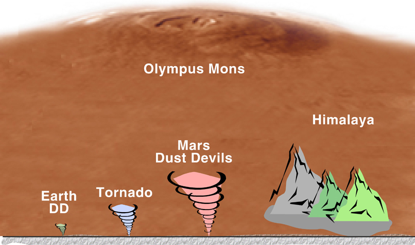
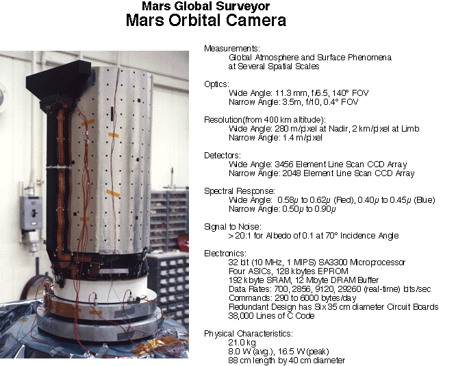
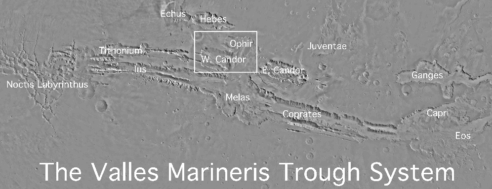