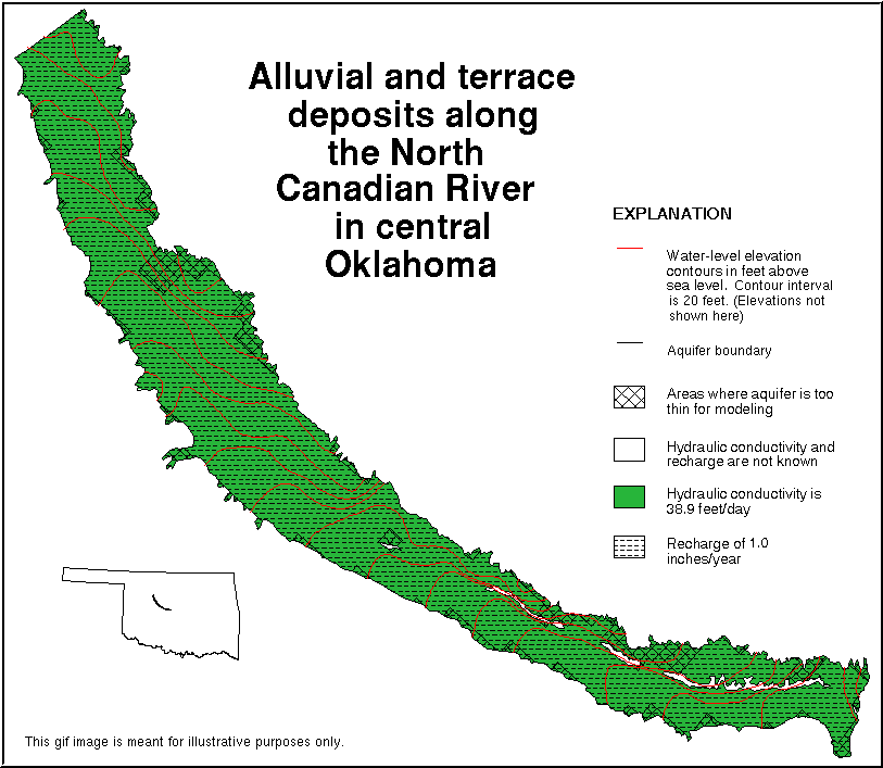
Digital data sets that describe aquifer characteristics of the alluvial and terrace deposits along the North Canadian River from Canton Lake to Lake Overholser in central Oklahoma
Content Description
Abstract: This data set consists of digital aquifer boundaries for the
alluvial and terrace deposits along the North Canadian River
from Canton Lake to Lake Overholser in central Oklahoma. Ground
water in approximately 400 square miles of Quaternary-age
alluvial and terrace aquifer is an important source of water for
irrigation, industrial, municipal, stock, and domestic supplies.
The aquifer consists of clay, silt, sand, and gravel. Sand-sized
sediments dominate the poorly sorted, fine to coarse,
unconsolidated quartz grains in the aquifer. The hydraulically
connected alluvial and terrace deposits unconformably overlie
Permian-age formations. The aquifer is overlain by a layer of
wind-blown sand in parts of the area.
The aquifer boundaries established in a ground-water modeling
report and are available in this data set include areas: 1)
where the alluvial and terrace deposits have been deposited
against relatively impermeable Permian-age formations; 2) where
the underlying Permian-age formations crop out within the
alluvial and the terrace deposits due to protruding high spots
on the Permian-age formations irregular surface; 3) where the
aquifer extends beyond the geographic limit of the study area
defined in the ground-water modeling report; and 4) where the
aquifer has little or no saturated thickness.
The lines in the data set representing aquifer boundaries along
geological contacts were extracted from published digital
surficial geology data sets based on a scale of 1:250,000.
Boundaries defining the northwest and southeast geographic
limits of the aquifer and areas of little or no saturated
thickness were digitized from folded paper maps, at a scale of
1:250,000, in the ground-water modeling report.
Purpose: This data set was created for a project to develop data sets to
support ground-water vulnerability analysis. The objective was
to create and document a digital geospatial data set from a
published report or map, or existing digital geospatial data
sets that could be used in ground-water vulnerability analysis.
Supplemental Information: Introduction --
This data set consists of digital aquifer boundaries for the
alluvial and terrace deposits along the North Canadian River
from Canton Lake to Lake Overholser in central Oklahoma. Ground
water in approximately 400 square miles of Quaternary-age
alluvial and terrace aquifer is an important source of water for
irrigation, industrial, municipal, stock, and domestic supplies.
The aquifer consists of clay, silt, sand, and gravel. Sand-sized
sediments dominate the poorly sorted, fine to coarse,
unconsolidated quartz grains in the aquifer. The hydraulically
connected alluvial and terrace deposits unconformably overlie
Permian-age formations. The aquifer is overlain by a layer of
wind-blown sand in parts of the area (Christenson, 1983).
The aquifer boundaries established in a ground-water modeling
report (Christenson, 1983) and are available in this data set
include areas: 1) where the alluvial and terrace deposits have
been deposited against relatively impermeable Permian-age
formations; 2) where the underlying Permian-age formations crop
out within the alluvial and the terrace deposits due to
protruding high spots on the Permian-age formations irregular
surface; 3) where the aquifer extends beyond the geographic
limit of the study area defined in the ground-water modeling
report; and 4) where the aquifer has little or no saturated
thickness.
The lines in the data set representing aquifer boundaries along
geological contacts were extracted from published digital
surficial geology data sets (Cederstrand, 1996a, 1996b, 1996c)
based on a scale of 1:250,000. The northwest and southeast
geographic limits of the aquifer and areas of little or no
saturated thickness were digitized from folded paper maps in the
ground-water modeling report, "Numerical simulation of the
alluvium and terrace aquifer along the North Canadian River from
Canton Lake to Lake Overholser, central Oklahoma," by
Christenson (1983, plates 1 and 6) at a scale of 1:250,000.
Reviews Applied to Data --
This electronic report was subjected to the same review standard
that applies to all U.S. Geological Survey reports. Reviewers
were asked to check the topological consistency, tolerances,
attribute frequencies and statistics, projection, and geographic
extent. Reviewers were given digital data sets and paper plots
for checking against the source maps to verify the linework and
attributes. The reviewers checked the metadata and a_readme.1st
files for completeness and accuracy.
Related Spatial and Tabular Data Sets --
This data set is one of four digital map data sets being published
together for this aquifer. The four data sets are:
> aqbound - aquifer boundaries
> cond - hydraulic conductivity
> recharg - aquifer recharge
> wlelev - water-level elevation contours
Digital map data sets of the Oklahoma surficial geology digitized from
1:250,000-scale maps (or 1:125,000-scale maps for the three Oklahoma
panhandle counties) are published separately.
Other References Cited --
Cederstrand, J.R., 1996a, Digital geologic map of Clinton
quadrangle, west-central Oklahoma: U.S. Geological Survey
Open-File Report 96-373, based on a scale of 1:250,000, 2
diskettes. (Available in nonproprietary and ARC/INFO formats.)
URL:http://wwwok.cr.usgs.gov/gis/geology/index.html
Cederstrand, J.R., 1996b, Digital geologic map of Oklahoma City
quadrangle, central Oklahoma: U.S. Geological Survey Open-File
Report 96-378, based on a scale of 1:250,000, 2 diskettes.
(Available in nonproprietary and ARC/INFO formats.)
URL:http://wwwok.cr.usgs.gov/gis/geology/index.html
Cederstrand, J.R., 1996c, Digital geologic map of Woodward
quadrangle, northwest Oklahoma: U.S. Geological Survey
Open-File Report 96-381, based on a scale of 1:250,000, 2
diskettes. (Available in nonproprietary and ARC/INFO formats.)
URL:http://wwwok.cr.usgs.gov/gis/geology/index.html
Christenson, S.C., 1983, Numerical simulation of the alluvium and
terrace aquifer along the North Canadian River from Canton Lake
to Lake Overholser, central Oklahoma: U.S. Geological Survey
Water Resources Investigations Report 83-4076, 36 p.
Environmental Systems Research Institute, Inc. (ESRI), 1995,
ARC/INFO Command Reference, ARC/INFO On-line manuals: Redlands,
CA.
Notes --
Any use of trade, product, or firm names is for descriptive
purposes only and does not imply endorsement by the U.S.
Government.
Although this data set has been used by the U.S. Geological
Survey, U.S. Department of the Interior, no warranty expressed or
implied is made by the U.S. Geological Survey as to the accuracy
of the data and related materials.
The act of distribution shall not constitute any such warranty,
and no responsibility is assumed by the U.S. Geological Survey in
the use of this data, software, or related materials.
Content Status
Progress: Complete
Update Frequency: None planned
Content Keywords
Theme Keywords: none, ground-water vulnerability, groundwater vulnerability, aquifers, ground water, groundwater, North Canadian River alluvial and terrace aquifer, North Canadian alluvial and terrace aquifer, alluvial and terrace aquifer, terrace aquifer, alluvial aquifer, terrace, alluvium, aquifer boundary, inlandWaters
Place Keywords: central Oklahoma