Local forecast by
Search by city or zip code. Press enter or select the go button to submit request
Preliminary Snowfall Reports from Feburary 4th Summary of the 2007-2008 North Carolina Drought Unofficial Snowfall Totals from Winter Storm 01-20-09
Quick Glimpse at the Weather
Newport/Morehead City, NC
Synopsis for Eastern North Carolina
A cold front over the Tennessee Valley Will race offshore by late tonight. High pressure Will build over the region Friday and Friday Night before low pressure moves from the Western Gulf Coast region to the off the Carolina Coast by Saturday Night. High pressure Will again build over the region before the Gulf Coast low develops around the middle of Next Week. ...See Full Discussion
Text Products
Area Forecast Matrices
Graphical
Satellite Imagery
Radar Imagery
National Forecast Map
Severe Weather Outlook
Severe Weather Watches
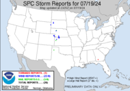
Severe Storm Reports
Current U.S. Drought Monitor Map
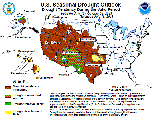
Seasonal U.S. Drought Outlook
Latest Observations in Eastern NC
NC Coast
Coastal Plain
Marine & Buoys
Location
Weather
Temp
Dewpt
RH
Wind(mph)
Pres
Remarks Edenton N/A 70°F 55°F 60% SW22G40 29.72in Elizabeth City PTCLDY 65°F 54°F 67% SW20G26 29.70in Kitty Hawk MOSUNNY 65°F 57°F 75% SW17G25 29.72in Manteo PTCLDY 63°F 57°F 82% SW28G35 29.73in Frisco CLOUDY 63°F 61°F 94% SW24G36 29.80in FOG Pea Island NOT AVBL Stumpy Point N/A 64°F SW15G48 29.77in Swan Quarter N/A 59°F S15G22 29.79in Beaufort CLOUDY 58°F 56°F 93% SW15 29.85in FOG Cedar Island N/A 64°F SW20G40 29.82in Jacksonville CLOUDY SW16G26 29.83in Newport N/A 61°F 59°F 94% SW10G26 Riseley Pier N/A 55°F 55°F 100% SW17 Wilmington MOCLDY 64°F 57°F 78% SW15G30 29.87in Observations as of 200 AM EST THU FEB 12 2009
Location
Weather
Temp
Dewpt
RH
Wind(mph)
Pres
Remarks Ahoskie N/A 68°F 61°F 77% S5 29.72 Clinton CLEAR 66°F 54°F 63% W18G24 29.85 Elizabethtown PTCLDY 68°F 53°F 57% SW16G23 29.86 Goldsboro CLEAR 65°F 59°F 81% SW21G30 29.79 Greenville CLEAR 66°F 55°F 68% SW21G30 29.79 Havelock MOCLDY 63°F 58°F 83% SW18G32 29.82 Kenansville CLEAR 66°F 55°F 68% SW15G24 29.83 Kinston CLEAR 64°F 55°F 72% SW14G22 29.80 New Bern MOCLDY 68°F 58°F 70% SW18G31 29.81 Richlands MOCLDY 66°F 57°F 72% SW13G18 29.84 Roanoke Rapids PTCLDY 65°F 52°F 62% W13G20 29.73 Rocky Mount CLEAR 64°F 53°F 67% SW16G23 29.77 Washington CLEAR 66°F 59°F 77% SW17G25 29.78 Whiteville PTCLDY 68°F 61°F 77% SW7G17 29.89 Observations as of 200 AM EST THU FEB 12 2009
Location
Time
Air
Sea
Wind(kts)
Pres
Wave
Swell Chesapeake Light C-MAN 0700Z 57°F 220° 31G33 1002.5mb Duck Research Pier Diamond Shoals (41025) 0700Z 69°F 66°F 1008.9mb 13ft / 8s Cape Lookout C-MAN 0700Z 63°F 220° 21G26 1010.7mb 5E New River (41035) 0700Z 56°F 49°F 220° 23G27 1010.4mb 6ft / 7s 3ft / 8s 30 SE New River (41036) 0700Z 62°F 56°F 200° 23G29 1010.9mb 10ft / 8s 5 SE Writsvle Bch (41038) 27 SE Wrtsvle Bch (41037) 0600Z 61°F 55°F 230° 19G23 1012.0mb Fryng Pan Shoals (41013) 0700Z 65°F 61°F VRB° 25/G31 1012.6mb 9ft / 8s 150 E Hatteras (41001) 250 E Charleston (41002) 0700Z 67°F 69°F 210° 25G31 1016.6mb 10ft / 7s 41 SE Charleston (41004) 0700Z 66°F 63°F 230° 23G27 1014.5mb 8ft / 8s 64 E Virginia Bch (44014) 0700Z 56°F 47°F 220° 29G35 1005.3mb 8ft / 6s