USGS Geoscience Data Catalog
Additional USGS Geoscience data can be found by geographic location or by publication series.
  File        Report Version        Last Update
              Last Updated

  mamap.ps      1.0
  maexpl.ps     1.0
  mageo.ps      1.0
  mamap.pdf     1.0
  maexpl.pdf    1.0
  mageo.pdf     1.0
  ma-geol.e00   1.0
  ma-strc.e00   1.0
  ma-blks.e00   1.0
  ma-altr.e00   1.0
  ma-quad.e00   1.0
  ma-corr.e00   1.0
  ma-so.e00     1.0
  ma-terr.e00   1.0
  mageo.txt     1.0
  mafig1.tif    1.0
  mafig2.tif    1.0
  madb.ps       1.0
  madb.pdf      1.0
  madb.txt      1.0
  import.aml    1.0
  mageol.met    1.0
Reviews_Applied_to_Data:
  ARC/INFO     Resultant	  Description of Coverage
  export file  Coverage
  -----------  -----------  --------------------------------
  ma-geol.e00  ma-geol/     Polygon and line coverage showing faults,
                            depositional contacts, and rock units
                            in the map area.

  ma-strc.e00  ma-strc/     Point and line coverage showing strike and dip
                            information and fold axes.

  ma-blks.e00  ma-blks/     Point coverage showing location of high-grade
                            blocks in Franciscan rock units.

  ma-altr.e00  ma-altr/     Polygon coverage showing areas of hydrothermal
                            alteration.

  ma-quad.e00  ma-quad/     Line coverage showing index map of quadrangles
                            in the map area.  Lines and annotation only.

  ma-corr.e00  ma-corr/     Polygon and line coverage of the correlation
                            table for the units in this map database.
                            This database is not geospatial.

  ma-so.e00    ma-so/       Line coverage showing sources of data index
                            map for this map database.

  ma-terr.e00  ma-terr/     Polygon and line coverage of the index map of
                            tectonostratigraphic terranes in the map area.
                            (Terranes are described in mageo.txt,
                            mageo.ps, or mageo.pdf).
ASCII text files, including explanatory text, ARC/INFO key files,
PostScript and PDF plot files, and a ARC Macro Language file for
conversion of ARC export files into ARC coverages:
  mageo.ps                A PostScript plot file of a report containing
                          detailed unit descriptions and geological
                          information, plus sources of data and references
                          cited, with two figures.

  mageo.pdf               A PDF version of mageo.ps.

  mageo.txt               A text-only file containing an unformatted
                          version of mageo.ps without figures.

  mafig1.tif              A TIFF file of Figure 1 from mageo.ps

  mafig2.tif              A TIFF file of Figure 2 from mageo.ps

  madb.ps                 A PostScript plot file of a pamphlet containing
                          detailed information about the contents and
                          availability of this report.

  madb.pdf                A PDF version of madb.ps.

  madb.txt                A text-only file containing an unformatted
                          version of madb.ps.

 import.aml               ASCII text file in ARC Macro Language to convert
                          ARC export files to ARC coverages in ARC/INFO.

  mamap.ps                A PostScript plottable file containing an image
                          of the geologic map and base maps at a scale of
                          1:62,500, along with a simple map key.

  maexpl.ps               A PostScript plot file containing an image of
                          the explanation sheet, including terrane map,
                          index maps, correlation chart, and unit
                          descriptions.

  mamap.pdf               A PDF file containing an image of the geologic
                          map and base maps at a scale of 1:62,500, along
                          with a simple map key.

  maexpl.pdf              A PDF file containing an image of the
                          explanation sheet, including terrane map, index
                          maps, correlation chart, and unit descriptions.
Base maps
Blake, M.C., Jr., Graymer, R.W., Jones, D.L., and Soule, A., 1999, Digital geologic map and map database of parts of Marin, San Francisco, Alameda, Contra Costa, and Sonoma Counties, California: U.S. Geological Survey Miscellaneous Field Studies Map MF-2337, U.S. Geological Survey, Menlo Park, CA.Online Links:
This is a Vector data set. It contains the following vector data types (SDTS terminology):
The map projection used is Lambert Conformal Conic.
Planar coordinates are encoded using coordinate pair
Abscissae (x-coordinates) are specified to the nearest 1.0
Ordinates (y-coordinates) are specified to the nearest 1.0
Planar coordinates are specified in METERS
The horizontal datum used is Unknown.
The ellipsoid used is Clarke 1866.
The semi-major axis of the ellipsoid used is 6378206.4.
The flattening of the ellipsoid used is 1/294.98.
| Value | Definition |
|---|---|
| Qaf | Artificial fill |
| Qmf | Artificial fill over marine and marsh deposits |
| Qs | Beach sand |
| Qd | Dune sand |
| Qm | Marine and marsh deposits |
| Qls | Landslide deposits |
| Qal | Alluvium |
| Qsr | Slope debris and ravine fill |
| Qu | Undifferentiated surficial deposits |
| Qr | Volcanic gravel |
| Qob | Older beach deposits |
| Qoal | Older alluvium |
| Qoal? | Older alluvium, identification uncertain |
| Qt | Marine and stream terrace deposits |
| Qmi | Millerton Formation |
| Qc | Colma Formation |
| QTm | Merced Formation |
| Twg | Wilson Grove Formation |
| Tps | Petaluma Formation, siltstone and claystone member |
| Tpc | Petaluma Formation, gray claystone member |
| Tsv | Sonoma Volcanics |
| Tsr | Sonoma Volcanics, rhyolite lava flows |
| Tsri | Sonoma Volcanics, rhyolite plugs and dikes |
| Tsa | Sonoma Volcanics, andesite to basalt lava flows |
| Tsa? | Sonoma Volcanics, andesite to basalt lava flows, identification uncertain |
| Tst | Sonoma Volcanics, pumiceous ash flow tuff |
| Ts | Unnamed sandstone |
| Tm | Monterey shale |
| Kfs | Franciscan complex, sandstone and shale |
| Kfs? | Franciscan complex, sandstone and shale, identification uncertain |
| Kfss | Franciscan complex, massive sandstone |
| Kfsh | Franciscan complex, thin-bedded shale |
| Kfl | Franciscan complex, limestone and chert |
| Kfg | Franciscan complex, greenstone |
| Kfch | Franciscan complex, chert |
| Kfgwy | Franciscan complex, graywacke |
| Kfdb | Franciscan complex, diabase |
| KJfm | Franciscan complex, meta-graywacke |
| KJfch | Franciscan complex, chert |
| KJfgc | Franciscan complex, greenstone and chert |
| Jfg | Franciscan complex, greenstone |
| Jfmgs | Franciscan complex, meta-greenstone |
| Jfmch | Franciscan complex, metachert |
| Jfmgc | Franciscan complex, meta-greenstone and metachert |
| Jfgs | Franciscan complex, greenstone |
| Jfmg | Franciscan complex, metamorphic rocks, gneissic |
| Jspm | Franciscan complex, massive serpentinite |
| fsr | Franciscan complex, melange |
| KJgv | Great Valley complex, undivided sandstone, shale, and conglomerate |
| Kgvn | Great Valley complex, Novato Conglomerate |
| KJgvs | Great Valley complex, sandstone and claystone |
| sp | Great Valley complex, serpentinite |
| sc | Great Valley complex, silica-carbonate rock |
| water | water |
| Value | Definition |
|---|---|
| contact, approx. located | Boundary between two mapped units that retains the original depositional or intrusive relationship (i.e. not faulted). The contact has not been observed, so it is not well-located as described in Positional_Accuracy, but the location is constrained to be within about 2 mm at map scale (1:62,500) or within about 125 meters on the ground. |
| contact, certain | Boundary between two mapped units that retains the original depositional or intrusive relationship (i.e. not faulted). The contact has been observed, so it is well-located as described in Positional_Accuracy. |
| contact, concealed | Boundary between two mapped units that retains the original depositional or intrusive relationship (i.e. not faulted). The contact is obscured by overlying mapped units, so it is not well-located as described in Positional_Accuracy, but the location is constrained to be within about 2 mm at map scale (1:62,500) or within about 125 meters on the ground. |
| contact, uncertain | Boundary between two mapped units that retains the original depositional or intrusive relationship (i.e. not faulted). The contact has not been observed, so it is not well-located as described in Positional_Accuracy, but the location is constrained to be within about 10 mm at map scale (1:62,500) or within about 625 meters on the ground. |
| fault, active | Structural boundary between mapped units or structural discontinuity within a mapped unit that has experienced and continues to experience relative offset between the rock bodies on either side of the fault. The fault has been observed, so it is well-located as described in Positional_Accuracy. |
| fault, active, approx. located | Structural boundary between mapped units or structural discontinuity within a mapped unit that has experienced and continues to experience relative offset between the rock bodies on either side of the fault. The contact has not been observed, so it is not well-located as described in Positional_Accuracy, but the location is constrained to be within about 2 mm at map scale (1:62,500) or within about 125 meters on the ground. |
| fault, approx. located | Structural boundary between mapped units or structural discontinuity within a mapped unit that has experienced relative offset between the rock bodies on either side of the fault. The contact has not been observed, so it is not well-located as described in Positional_Accuracy, but the location is constrained to be within about 2 mm at map scale (1:62,500) or within about 125 meters on the ground. |
| fault, certain | Structural boundary between mapped units or structural discontinuity within a mapped unit that has experienced relative offset between the rock bodies on either side of the fault. The fault has been observed, so it is well-located as described in Positional_Accuracy. |
| fault, concealed | Structural boundary between mapped units or structural discontinuity within a mapped unit that has experienced relative offset between the rock bodies on either side of the fault. The fault is obscured by overlying mapped units, so it is not well-located as described in Positional_Accuracy, but the location is constrained to be within about 10 mm at map scale (1:62,500) or within about 625 meters on the ground. |
| fault, inferred, queried | Structural boundary between mapped units or structural discontinuity within a mapped unit that has experienced relative offset between the rock bodies on either side of the fault. The fault has not been observed, so it is not well-located as described in Positional_Accuracy, but the location is constrained to be within about 10 mm at map scale (1:62,500) or within about 625 meters on the ground. The existence of the fault is inferred from structural and stratigraphic relationships observed elsewhere. |
| fault, uncertain | Structural boundary between mapped units or structural discontinuity within a mapped unit that has experienced relative offset between the rock bodies on either side of the fault. The fault has not been observed, so it is not well-located as described in Positional_Accuracy, but the location is constrained to be within about 10 mm at map scale (1:62,500) or within about 625 meters on the ground. |
| map boundary, | Edge of the mapped area. Used primarily to bound polygons at the edge of the map database. The location of the boundary is well located as described in Positional_Accuracy |
| normal fault, approx. located | Structural boundary between mapped units or structural discontinuity within a mapped unit that has experienced normal offset between the rock bodies on either side of the fault. The contact has not been observed, so it is not well-located as described in Positional_Accuracy, but the location is constrained to be within about 2 mm at map scale (1:62,500) or within about 125 meters on the ground. |
| normal fault, certain | Structural boundary between mapped units or structural discontinuity within a mapped unit that has experienced normal offset between the rock bodies on either side of the fault. The fault has been observed, so it is well-located as described in Positional_Accuracy. |
| normal fault, concealed | Structural boundary between mapped units or structural discontinuity within a mapped unit that has experienced normal offset between the rock bodies on either side of the fault. The fault is obscured by overlying mapped units, so it is not well-located as described in Positional_Accuracy, but the location is constrained to be within about 10 mm at map scale (1:62,500) or within about 625 meters on the ground. |
| normal fault, uncertain | Structural boundary between mapped units or structural discontinuity within a mapped unit that has experienced normal offset between the rock bodies on either side of the fault. The fault has not been observed, so it is not well-located as described in Positional_Accuracy, but the location is constrained to be within about 10 mm at map scale (1:62,500) or within about 625 meters on the ground. |
| scratch boundary, | An arbitrary line with no geologic significance. Used primarily to divide polygons that would otherwise have more vertices than allowed by Arc/Info. |
| scratch boundary, certain | An arbitrary line with no geologic significance. Used primarily to divide polygons that would otherwise have more vertices than allowed by Arc/Info. |
| thrust fault, approx. located | Structural boundary between mapped units or structural discontinuity within a mapped unit that has experienced thrust offset between the rock bodies on either side of the fault. The contact has not been observed, so it is not well-located as described in Positional_Accuracy, but the location is constrained to be within about 2 mm at map scale (1:62,500) or within about 125 meters on the ground. |
| thrust fault, certain | Structural boundary between mapped units or structural discontinuity within a mapped unit that has experienced thrust offset between the rock bodies on either side of the fault. The fault has been observed, so it is well-located as described in Positional_Accuracy. |
| thrust fault, concealed | Structural boundary between mapped units or structural discontinuity within a mapped unit that has experienced thrust offset between the rock bodies on either side of the fault. The fault is obscured by overlying mapped units, so it is not well-located as described in Positional_Accuracy, but the location is constrained to be within about 10 mm at map scale (1:62,500) or within about 625 meters on the ground. |
| thrust fault, concealed, queried | Structural boundary between mapped units or structural discontinuity within a mapped unit that has experienced thrust offset between the rock bodies on either side of the fault. The fault is obscured by overlying mapped units, so it is not well-located as described in Positional_Accuracy, but the location is constrained to be within about 10 mm at map scale (1:62,500) or within about 625 meters on the ground. The existence of this fault has been inferred from probable stratigraphic and structural relationships observed at a regional scale. |
| thrust fault, inferred | Structural boundary between mapped units or structural discontinuity within a mapped unit that has experienced thrust offset between the rock bodies on either side of the fault. The fault has not been observed, so it is not well-located as described in Positional_Accuracy, but the location is constrained to be within about 10 mm at map scale (1:62,500) or within about 625 meters on the ground. The existence of the fault is inferred from structural and stratigraphic relationships observed elsewhere. |
| thrust fault, inferred, queried | Structural boundary between mapped units or structural discontinuity within a mapped unit that has experienced thrust offset between the rock bodies on either side of the fault. The fault has not been observed, so it is not well-located as described in Positional_Accuracy, but the location is constrained to be within about 10 mm at map scale (1:62,500) or within about 625 meters on the ground. The existence of this fault has been inferred from probable stratigraphic and structural relationships observed at a regional scale. |
| thrust fault, uncertain | Structural boundary between mapped units or structural discontinuity within a mapped unit that has experienced thrust offset between the rock bodies on either side of the fault. The fault has not been observed, so it is not well-located as described in Positional_Accuracy, but the location is constrained to be within about 10 mm at map scale (1:62,500) or within about 625 meters on the ground. |
| water boundary | The edge of a mapped body of water. This line is derived from the base map, and therefore is well-located as described in Positional_Accuracy. |
| water boundary, | The edge of a mapped body of water. This line is derived from the base map, and therefore is well-located as described in Positional_Accuracy. |
| water boundary, certain | The edge of a mapped body of water. This line is derived from the base map, and therefore is well-located as described in Positional_Accuracy. |
| Value | Definition |
|---|---|
| approx bedding | Originally horizontal sedimentary layers were observed at this point. Because of poor exposure, weathering, indistinct layering, or some other factor, only the approximate orientation of the layers was measured. |
| bedding | Originally horizontal sedimentary layers were observed at this point. |
| bedding w/tops | Originally horizontal sedimentary layers were observed at this point. In addition, a geopedal indicator was observed that showed the beds were upright. |
| fault dip | A fault plane or other evidence of the orientation of a fault plane was observed at this point. |
| foliation | Metamorphic foliation was observed at this point. |
| ot bedding | Originally horizontal sedimentary layers were observed at this point. Evidence that the beds are overturned was observed, although that observation may not have been made at this point. |
| pillow lava | Originally sub-horizontal lobate structures formed in sub-aqueous lava flows were observed at this point. |
| vert bedding | Originally horizontal sedimentary layers were observed at this point. These layers are now vertical. |
| vert foliation | Vertical metamorphic foliation was observed at this point. |
| Range of values | |
|---|---|
| Minimum: | 0 |
| Maximum: | 90 |
| Units: | degrees |
| Resolution: | 1 |
| Range of values | |
|---|---|
| Minimum: | 0 |
| Maximum: | 359 |
| Units: | degrees |
| Resolution: | 1 |
| Value | Definition |
|---|---|
| (none) | No features of this type were recorded in this report |
| Value | Definition |
|---|---|
| blk.h | High-grade metamorphic block |
| blk.l | Low-grade metamorphic block |
| Value | Definition |
|---|---|
| c | Chert (KJfch) |
| g | Greenstone (Jfgs) |
| h | Gneissic metamorphic rocks (Jfmg) |
| n | Silica-carbonate rock (sc) |
| p | |
| r | Metachert (Jfmch) |
| s | Serpentinite (sp) |
| u | Meta-greenstone (Jfmgs) |
| w | Graywacke (Jfgwy) |
| Value | Definition |
|---|---|
| ha | Hydrothermal alteration was observed in this area |
| Value | Definition |
|---|---|
| scratch boundary, | The edge of mapped areas of hydrothermal alteration. This boundary is not well-located as described in Attribute_Accuracy, but the location is constrained to be within about 2 mm at map scale (1:62,500) or within about 125 meters on the ground. The contact is gradational. |
| Value | Definition |
|---|---|
| water | Areas of water in the mapped area |
| Value | Definition |
|---|---|
| map boundary | Edge of the mapped area. The location of the boundary is well located as described in Positional_Accuracy |
| map boundary, | Edge of the mapped area. The location of the boundary is well located as described in Positional_Accuracy |
| quad, | Edge of a USGS 7.5 minute quadrangle in the map area. This line is derived from a 7.5 minute grid generated from latitude and longitude values and therefore should be precisely located. |
| water boundary | The edge of a mapped body of water. This line is derived from the base map, and therefore is well-located as described in Positional_Accuracy. |
| water boundary, | The edge of a mapped body of water. This line is derived from the base map, and therefore is well-located as described in Positional_Accuracy. |
| Value | Definition |
|---|---|
| Qaf | Artificial fill |
| Qmf | Artificial fill over marine and marsh deposits |
| Qs | Beach sand |
| Qd | Dune sand |
| Qm | Marine and marsh deposits |
| Qls | Landslide deposits |
| Qal | Alluvium |
| Qsr | Slope debris and ravine fill |
| Qu | Undifferentiated surficial deposits |
| Qr | Volcanic gravel |
| Qob | Older beach deposits |
| Qoal | Older alluvium |
| Qt | Marine and stream terrace deposits |
| Qmi | Millerton Formation |
| Qc | Colma Formation |
| QTm | Merced Formation |
| Twg | Wilson Grove Formation |
| Tps | Petaluma Formation, siltstone and claystone member |
| Tpc | Petaluma Formation, gray claystone member |
| Tsv | Sonoma Volcanics |
| Tsr | Sonoma Volcanics, rhyolite lava flows |
| Tsri | Sonoma Volcanics, rhyolite plugs and dikes |
| Tsa | Sonoma Volcanics, andesite to basalt lava flows |
| Tst | Sonoma Volcanics, pumiceous ash flow tuff |
| Ts | Unnamed sandstone |
| Tm | Monterey shale |
| Kfs | Franciscan complex, sandstone and shale |
| Kfss | Franciscan complex, massive sandstone |
| Kfsh | Franciscan complex, thin-bedded shale |
| Kfl | Franciscan complex, limestone and chert |
| Kfg | Franciscan complex, greenstone |
| Kfch | Franciscan complex, chert |
| Kfgwy | Franciscan complex, graywacke |
| Kfdb | Franciscan complex, diabase |
| KJfm | Franciscan complex, meta-graywacke |
| KJfch | Franciscan complex, chert |
| KJfgc | Franciscan complex, greenstone and chert |
| Jfg | Franciscan complex, greenstone |
| Jfmgs | Franciscan complex, meta-greenstone |
| Jfmch | Franciscan complex, metachert |
| Jfmgc | Franciscan complex, meta-greenstone and metachert |
| Jfgs | Franciscan complex, greenstone |
| Jfmg | Franciscan complex, metamorphic rocks, gneissic |
| Jspm | Franciscan complex, massive serpentinite |
| fsr | Franciscan complex, melange |
| KJgv | Great Valley complex, undivided sandstone, shale, and conglomerate |
| Kgvn | Great Valley complex, Novato Conglomerate |
| KJgvs | Great Valley complex, sandstone and claystone |
| sp | Great Valley complex, serpentinite |
| sc | Great Valley complex, silica-carbonate rock |
| Value | Definition |
|---|---|
| box | Edge of a box in the correlation chart |
| box, | Edge of a box in the correlation chart |
| brack, | Bracket line in the correlation chart |
| Value | Definition |
|---|---|
| 1 | Source region 1 |
| 10 | Source region 10 |
| 11 | Source region 11 |
| 12 | Source region 12 |
| 13 | Source region 13 |
| 14 | Source region 14 |
| 15 | Source region 15 |
| 16 | Source region 16 |
| 17 | Source region 17 |
| 18 | Source region 18 |
| 19 | Source region 19 |
| 2 | Source region 2 |
| 20 | Source region 20 |
| 21 | Source region 21 |
| 22 | Source region 22 |
| 3 | Source region 3 |
| 4 | Source region 4 |
| 5 | Source region 5 |
| 5a | Source region 5a |
| 6 | Source region 6 |
| 7 | Source region 7 |
| 8 | Source region 8 |
| 9 | Source region 9 |
| 9&14 | Sources from both region 9 and 14 |
| water | Region of open water with no mapped geology. |
| Value | Definition |
|---|---|
| county, boundary | The boundary between counties in the index map area. This line is not well-located as described in Positional_Accuracy, and is included for general reference only. |
| leader | A line included for plotting purposes only to allow the labeling of some small areas. This line is not well-located as described in Positional_Accuracy, and is included for general reference only. |
| map boundary, | The edge of the index map area. |
| source, boundary | The boundary between regions within which different sources of data were used to supplement new mapping by the authors. The sources are delineated in Source_Information as well as Sheet 2 plotfiles maexpl.ps and maexpl.pdf. This line is not well-located as described in Positional_Accuracy, and is included for general reference only. |
| water boundary, | The edge of a mapped body of water. This line is not well-located as described in Positional_Accuracy, and is included for general reference only. |
| Value | Definition |
|---|---|
| H2O | water |
| KJfm? | Franciscan Complex, metasandstone of unknown terrane affinity |
| Q | Area where terranes are covered with Quaternary surficial deposits |
| T | Area where terranes are covered with Tertiary overlap strata |
| cro | Great Valley Complex, Coast Range Ophiolite |
| fai | Franciscan Complex, Alacatraz terrane |
| fg | Franciscan Complex, greenstone of unknown terrane affinity |
| fm | Franciscan Complex, melange or Central terrane |
| fmh | Franciscan Complex, Marin Headlands terrane |
| fmh? | Franciscan Complex, Marin Headlands terrane, identification uncertain. |
| fnq | Franciscan Complex, Novato Quarry terrane |
| fnr | Franciscan Complex, Nicasio Reservoir terrane |
| fpb | Franciscan Complex, Permanente terrane |
| fsb | Franciscan Complex, San Bruno Mountain terrane |
| fyb | Franciscan Complex, Yolla Bolly terrane |
| fyb? | Franciscan Complex, Yolla Bolly terrane, identification uncertain |
| gvh | Great Valley Complex, Healdsburg terrane |
| s | Salinian Complex, undivided |
| Value | Definition |
|---|---|
| contact, approx. located | Boundary between two mapped units that retains the original depositional or intrusive relationship (i.e. not faulted). The contact has not been observed, so it is not well-located as described in Positional_Accuracy, but the location is constrained to be within about 2 mm at map scale (1:62,500) or within about 125 meters on the ground. |
| contact, certain | Boundary between two mapped units that retains the original depositional or intrusive relationship (i.e. not faulted). The contact has been observed, so it is well-located as described in Positional_Accuracy. |
| contact, concealed | Boundary between two mapped units that retains the original depositional or intrusive relationship (i.e. not faulted). The contact is obscured by overlying mapped units, so it is not well-located as described in Positional_Accuracy, but the location is constrained to be within about 2 mm at map scale (1:62,500) or within about 125 meters on the ground. |
| fault, active | Structural boundary between mapped units or structural discontinuity within a mapped unit that has experienced and continues to experience relative offset between the rock bodies on either side of the fault. The fault has been observed, so it is well-located as described in Positional_Accuracy. |
| fault, approx. located | Structural boundary between mapped units or structural discontinuity within a mapped unit that has experienced relative offset between the rock bodies on either side of the fault. The contact has not been observed, so it is not well-located as described in Positional_Accuracy, but the location is constrained to be within about 2 mm at map scale (1:62,500) or within about 125 meters on the ground. |
| fault, certain | Structural boundary between mapped units or structural discontinuity within a mapped unit that has experienced relative offset between the rock bodies on either side of the fault. The fault has been observed, so it is well-located as described in Positional_Accuracy. |
| fault, concealed | Structural boundary between mapped units or structural discontinuity within a mapped unit that has experienced relative offset between the rock bodies on either side of the fault. The fault is obscured by overlying mapped units, so it is not well-located as described in Positional_Accuracy, but the location is constrained to be within about 10 mm at map scale (1:62,500) or within about 625 meters on the ground. |
| fault, inferred | Structural boundary between mapped units or structural discontinuity within a mapped unit that has experienced relative offset between the rock bodies on either side of the fault. The fault has not been observed, so it is not well-located as described in Positional_Accuracy, but the location is constrained to be within about 10 mm at map scale (1:62,500) or within about 625 meters on the ground. The existence of the fault is inferred from structural and stratigraphic relationships observed elsewhere. |
| fault, low-angle thrust, approx. lo | Structural boundary between mapped units or structural discontinuity within a mapped unit that has experienced thrust offset between the rock bodies on either side of the fault. The contact has not been observed, so it is not well-located as described in Positional_Accuracy, but the location is constrained to be within about 2 mm at map scale (1:62,500) or within about 125 meters on the ground. The dip of the fault plane is less than 15 degrees. |
| fault, low-angle thrust, certain | Structural boundary between mapped units or structural discontinuity within a mapped unit that has experienced thrust offset between the rock bodies on either side of the fault. The fault has been observed, so it is well-located as described in Positional_Accuracy. The dip of the fault plane is less than 15 degrees. |
| fault, uncertain | Structural boundary between mapped units or structural discontinuity within a mapped unit that has experienced relative offset between the rock bodies on either side of the fault. The fault has not been observed, so it is not well-located as described in Positional_Accuracy, but the location is constrained to be within about 10 mm at map scale (1:62,500) or within about 625 meters on the ground. |
| leader | A line used in concert with annotation to indicate the identity of selected small areas. The line has no other geologic or geographic significance, and its position is arbitrary. |
| map boundary, | Edge of the mapped area. Used primarily to bound polygons at the edge of the map database. The location of the boundary is well located as described in Positional_Accuracy |
| reverse fault, approx. located | Structural boundary between mapped units or structural discontinuity within a mapped unit that has experienced reverse offset between the rock bodies on either side of the fault. The contact has not been observed, so it is not well-located as described in Positional_Accuracy, but the location is constrained to be within about 2 mm at map scale (1:62,500) or within about 125 meters on the ground. |
| reverse fault, certain | Structural boundary between mapped units or structural discontinuity within a mapped unit that has experienced reverse offset between the rock bodies on either side of the fault. The fault has been observed, so it is well-located as described in Positional_Accuracy. |
| reverse fault, concealed | Structural boundary between mapped units or structural discontinuity within a mapped unit that has experienced reverse offset between the rock bodies on either side of the fault. The fault is obscured by overlying mapped units, so it is not well-located as described in Positional_Accuracy, but the location is constrained to be within about 10 mm at map scale (1:62,500) or within about 625 meters on the ground. |
| reverse fault, inferred | Structural boundary between mapped units or structural discontinuity within a mapped unit that has experienced reverse offset between the rock bodies on either side of the fault. The fault has not been observed, so it is not well-located as described in Positional_Accuracy, but the location is constrained to be within about 10 mm at map scale (1:62,500) or within about 625 meters on the ground. |
| reverse fault, inferred, queried | Structural boundary between mapped units or structural discontinuity within a mapped unit that has experienced reverse offset between the rock bodies on either side of the fault. The fault has not been observed, so it is not well-located as described in Positional_Accuracy, but the location is constrained to be within about 10 mm at map scale (1:62,500) or within about 625 meters on the ground. The existence of this fault is inferred from probable regional and structural relationships. |
| scratch boundary, | An arbitrary line with no geologic significance. Used primarily to divide polygons that would otherwise have more vertices than allowed by Arc/Info. |
| thrust fault, certain | Structural boundary between mapped units or structural discontinuity within a mapped unit that has experienced thrust offset between the rock bodies on either side of the fault. The fault has been observed, so it is well-located as described in Positional_Accuracy. |
| thrust fault, concealed | Structural boundary between mapped units or structural discontinuity within a mapped unit that has experienced thrust offset between the rock bodies on either side of the fault. The fault is obscured by overlying mapped units, so it is not well-located as described in Positional_Accuracy, but the location is constrained to be within about 10 mm at map scale (1:62,500) or within about 625 meters on the ground. |
| water boundary | The edge of a mapped body of water. This line is derived from the base map, and therefore is well-located as described in Positional_Accuracy. |
| water boundary, | The edge of a mapped body of water. This line is derived from the base map, and therefore is well-located as described in Positional_Accuracy. |
| water boundary, certain | The edge of a mapped body of water. This line is derived from the base map, and therefore is well-located as described in Positional_Accuracy. |
We would like to acknowledge our many colleagues at the USGS, University of California, and Stanford University for their many contributions over the years. We would especially like to acknowledge R.C. Jachens and E.E. Brabb for many organizational efforts, participation in the new mapping, ideas about regional structure, and insightful review of our draft manuscript.
We are grateful to the following U.S. Geological Survey paleontologists who have examined our fossils and provided ages necessary to establish the stratigraphic sequence and structure: David Bukry (Cretaceous and Tertiary nannoplankton), Kristin McDougall (Tertiary foraminifers), William Sliter (deceased - Cretaceous and Eocene foraminifers), John Barron (Tertiary diatoms), Charles Powell, II (Tertiary mollusks), and Bonita Murchey (Mesozoic radiolaria).
We are also very grateful to managers and staff of Chevron, EXXON, UNOCAL, ARCO, and Shell Petroleum Companies who have provided reports, maps, picked slides, and residues for about 25,000 microfossil localities in the San Francisco Bay Region.
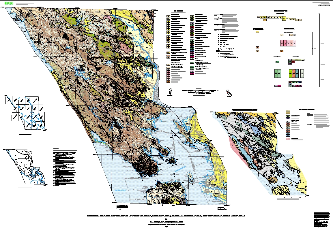
This database and accompanying plot files depict the distribution of geologic materials and structures at a regional (1:62,500) scale. The report is intended to provide geologic information for the regional study of materials properties, earthquake shaking, landslide potential, mineral hazards, seismic velocity, and earthquake faults. In addition, the report contains new information and interpretations about the regional geologic history and framework. However, the regional scale of this report does not provide sufficient detail for site development purposes. In addition, this map does not take the place of fault-rupture hazard zones designated by the California State Geologist (Hart and Bryant, 1997). Similarly, the database cannot be used to identify or delineate landslides in the region.
Fox, K.F., Jr, unpublished geologic map.
Brown, R.D., Jr, 1970, Faults that are historically active or that show evidence of geologically young surface displacement, San Francisco Bay Region: A progress report: U.S. Geological Survey Open-File Report.
Weaver, 1949, (Weaver, 1949, region 2).
Louke, G., unpublished, unpublished geologic investigations.
Bartow, J.A., unpublished photogeology and field reconnaissance.
Nichols, D.R., and Wright, N.A., 1971, Preliminary map of historic margins of marshland, San Francisco Bay, California: U.S. Geological Survey Open-File Report.
Rose, R.L., unpublished geologic investigations.
Bartow, J.A, unpublished geologic investigations.
Blake, M.C., Jr., and Wright, R.H., unpublished geologic investigations.
Wentworth, C.M., unpublished photogeology.
Berkland, J.O., 1969, Geology of the Novato quadrangle, Marin County, California.
Berkland, J.O., unpublished geologic investigations.
O'Rourke, J.T., 1969, Geology of the San Anselmo Area.
Blake, M.C., Jr., and Wright, R.H., minor unpublished geologic investigations.
Rice, S., unpublished geologic investigations.
Wahrhaftig, C., 1984, Structure of the Marin Headlands block, California: A progress report: Pacific Section, SEPM 43.
Wahrhaftig, C., 1989, (Wahrhaftig, 1989, region 7).
Blake, M.C., Jr., and Wright, R.H., minor unpublished geologic investigations.
Schlocker, J., unpublished geologic investigations.
Wahrhaftig, C., 1984, Structure of the Marin Headlands block, California: A progress report: Pacific Section, SEPM 43.
Wahrhaftig, C., 1989, (Wahrhaftig, 1989, region 8).
Galloway, A.J., Geology of the Point Reyes Peninsula, Marin County, California: California Division of Mines and Geology Special Report.
Gluskoter, H. J., 1969, Geology of a portion of western Marin County, California: California Division of Mines and Geology Map 11.
Bartow, unpublished geologic investigation.
Clague, J. J., 1969, The landslides in the southeast part of Point Reyes National Seashore.
Wright, R.H., and Blake, M.C., Jr., unpublished geologic investigations.
Sorg, D., unpublished geologic investigations.
Gluskoter, H. J., 1969, Geology of a portion of western Marin County, California: California Division of Mines and Geology Map 11.
Wright, R.H., and Blake, M.C., Jr., unpublished geologic investigations.
Gluskoter, H. J., 1969, Geology of a portion of western Marin County, California: California Division of Mines and Geology Map 11.
Wahrhaftig, C., 1970, (Wahrhaftig, 1970, region 13).
Wright, R.H., and Blake, M.C., Jr., unpublished geologic investigations.
Brown, R.D., and Wolfe, E.W., 1970, Map showing recently active breaks along the San Andreas fault between Pt. Delgada and Bolinas Bay, California: U.S. Geological Survey Open-File Report.
Bartow, J.A., field reconnaissance.
Wright, R.H., and Blake, M.C., Jr., unpublished geologic investigations.
Weaver, 1949, (Weaver, 1949, region 16).
Blake, M.C., Jr., and Wright, R.H., unpublished geologic investigations.
Blake, M.C., Jr., unpublished geologic investigations.
Lawson, A. C., 1914, San Francisco Folio: U.S. Geological Survey Atlas Folio 193.
Blake, M.C., Jr., and Wright, R.H., unpublished geologic investigations.
Schlocker, J., Bonilla, M. G., and Radbruch, D. H., 1958, Geology of the San Francisco North quadrangle, California: U.S. Geological Survey Miscellaneous Investigations Series Map I-272.
Blake, M.C., Jr., unpublished geologic investigations.
Alfors, J., unpublished geologic investigations.
Rice, S., unpublished geologic investigations.
Blake, M.C., Jr., unpublished geologic investigations.
Brown, R.D., and Wolfe, E.W., 1970, Map showing recently active breaks along the San Andreas fault between Pt. Delgada and Bolinas Bay, California: U.S. Geological Survey Open-File Report.
Blake, M.C., Jr., Helley, E.J., and Lajoie, K.R., unpublished geologic investigations.
Radbruch, D.H., 1957, Areal and engineering geology of the Oakland west quadrangle, California: U.S. Geological Survey Miscellaneous Investigations Series Map I-239.
Blake, M.C., Jr., unpublished geologic investigations.
Gluskoter, H. J., 1969, Geology of a portion of western Marin County, California: California Division of Mines and Geology Map 11.
Blake, M.C., Jr., and Wright, R.H., unpublished geologic investigations.
Blake, M.C., Jr., unpublished geologic investigations.
Bonilla, M. G., 1971, Preliminary geolgic map of the San Francisco South quadrangle and part of the Hunters Point quadrangle, California: U.S. Geological Survey Miscellaneous Field Studies Map MF-311.
Well located data items are intended to have a horizontal positional
accuracy within .2 mm at 1:62,500 scale, or within 12.5 meters on
the ground. The general positional accuracy of each line in the
database is indicated within the LTYPE field in the Arc Attribute
Table (see below). Points in the database are generally considered
to be well located. The position of each data item is derived from
the USGS topographic base map, and therefore additional inaccuracies
arising from inaccuracies in the base map may also be encountered.
See Aitken (1997) for information regarding the horizontal positional
accuracy of the basemaps.
No vertical positional data recorded. See Aitken (1997) for information
regarding the vertical positional accuracy of the basemaps used to
create the plotfiles of the geologic maps.
The report is intended to describe completely the bedrock geology at
1:62,500 scale. Geologic information only mappable at larger scale has
been omitted. In addition, landslide deposits are for the most part not
recorded. Further, Quaternary surficial deposits in many areas have been
intentionally undifferentiated.
Polygon and chain-node topology present
Are there legal restrictions on access or use of the data?
- Access_Constraints: None
- Use_Constraints:
- Uses of this digital geologic map should not violate the spatial resolution of the data. Although the digital form of the data removes the constraint imposed by the scale of a paper map, the detail and accuracy inherent in map scale are also present in the digital data. The fact that this database was edited for a scale of 1:62,500 means that higher resolution information is not present in the dataset. Plotting at scales larger than 1:62,500 will not yield greater real detail, although it may reveal fine-scale irregularities below the intended resolution of the database. Similarly, where this database is used in combination with other data of higher resolution, the resolution of the combined output will be limited by the lower resolution of these data.
USGS Miscellaneous Field Studies Report MF-2337
| Data format: | Polygon, line, and point data with attributes in format ARCE (version 7.x) Uncompressed ARC export Size: 5 megabytes |
|---|---|
| Network links: |
<http://pubs.usgs.gov/mf/2000/2337/mf2337c.tgz> |
ARC/INFO version 7.x or later

![]() U.S. Department of the Interior |
U.S. Geological Survey
U.S. Department of the Interior |
U.S. Geological Survey
URL: http://geo-nsdi.er.usgs.gov/metadata/map-mf/2337/metadata.faq.html
Page Contact Information: Peter Schweitzer
Page Last Modified: Monday, 10-Nov-2008 12:18:30 EST
