
Research Highlights
June 2006
An Eye on Sky Imaging Systems and Techniques

In comparing fractional sky cover data between automated processing methods and human retrievals—both from direct observations and visual analyses of sky images—PNNL researcher Chuck Long, along with colleagues from the University of Girona in Spain, and the University of Southern Queensland in Australia, found no significant difference in the uncertainties between the two techniques. Because of the cost associated with obtaining these retrievals through human observation, the application of automatic digital image processing techniques is a useful method to complement, or even replace, traditional manual observations of sky cover, and, potentially, cloud type. In addition, the possibilities for inferring other cloud parameters, such as cloud brokenness and solar obstruction, further enhance the usefulness of sky imagers. This information is important for scientists refining parameterizations used in computer models that simulate climate change.
One common concern with sky images is the effect of image mapping distortion. In sky images, equal areas (or equal number of pixels) in the image correspond to different solid angles due to mapping the hemisphere onto a flat (1-dimensional) circular area. Analyses by the researchers show that this mapping distortion generally produces on the order of only 1-2% error in retrieved fractional sky cover.
Another problem with many sky imager retrievals is error in clear/cloud determination for the areas near the sun in the image, and along the horizon centered on the solar azimuth angle at low solar elevations. These areas of the image are naturally whiter than other parts of the cloudless sky in the image due to scattering of visible light by the molecules and aerosol/haze particles in the atmosphere. These pixels are often interpreted as "cloudy" in the sky imager retrievals when a human observer would label them as "cloudless." Figure 1 is an extreme example of this type of sky cover retrieval error, as observed by the sky imager instrument at PNNL's Atmospheric Remote Sensing Laboratory.
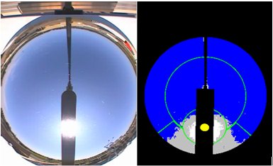
Figure 1. Sky image (left) from 1300 local time, September 4, 2004, at the Pacific Northwest National Laboratory, Richland, Washington. At right is the corresponding retrieval image denoting clear sky (blue), thin cloud (grey), and opaque cloud (white). Black denotes masked portions not counted in sky cover retrievals. Note the "cloudy" area near and below the sun in the cloud retrieval image, versus the virtually clear sky shown in the sky image.
The researchers used a statistical methodology to correct for these errors given highly sampled (1-minute or better) sky cover retrievals. The original erroneous sky cover retrievals and the more accurate results of the retrieval using their correction method are shown in Figure 2.
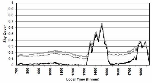
Figure 2. Total sky cover retrieval for September 4, 2004 at the Pacific Northwest National Laboratory. The grey line is the original retrieval, thin black line is the retrieval including the "first guess" adjustment of the sun circle area, and the black line is the final corrected result.
The U.S. Department of Energy's Office of Biological and Environmental Research, Climate Change Research Division, supported this research.
Citation: Long, CN, JM Sabburg, J Calbó, and D Pagès. 2006. "Retrieving Cloud Characteristics from Ground-Based Daytime Color All-Sky Images." Journal of Atmospheric and Oceanic Technology: Vol. 23, No. 5, pp. 633-652.